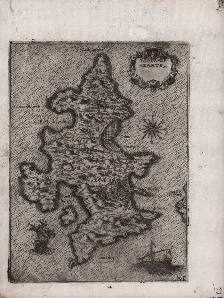
Isola de Zante
Isola de Zante | Stampe | BONIFACIO Natale

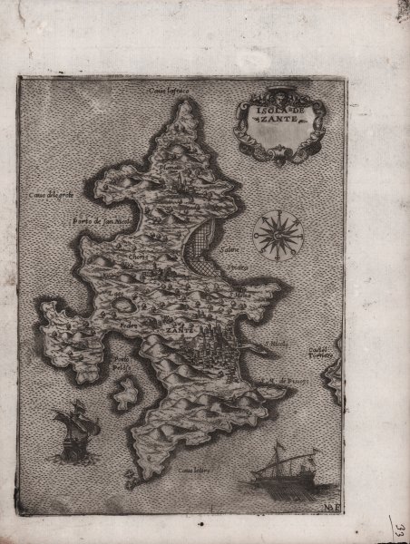
Isola de Zante
Isola de Zante | Stampe | BONIFACIO Natale
Metodi di Pagamento
- PayPal
- Carta di Credito
- Bonifico Bancario
- Pubblica amministrazione
- Carta del Docente
Dettagli
- Anno di pubblicazione
- 1568
- Luogo di stampa
- Venezia
- Formato
- 155 X 210
- Incisori
- BONIFACIO Natale
- Descrizione
- Gallo (1950): p. 97, n. 42 e p. 99, n. 26; Tolias (2011): n. 0390; Zacharakis (1992): n. 508; Zacharakis (2009): n. 782.
Descrizione
In basso a sinistra in una targa ZANTE insula posta nel mare Mediteraneo longi dalla Morea mil. 25. locho delli Ill.mi Venetiani abondante di bonissimi vini, pece, vene di metalli ma sottoposta a teremotti, et tiene di circuito da mill. 60 con bonissimo aere. In alto rosa dei venti con il nord in alto. Nell’angolo in basso a destra il numero 42. Carta priva di scala grafica e graduazione ai margini. Acquaforte e bulino, mm 172x206.Notizie storico critiche: Carta anonima, priva di data ed indicazioni editoriali, edita da Camocio. La mappa circolava come carta sciolta prima di essere inserita nella raccolta Isole famose, porti, fortezze e terre marittime sottoposte alla Serenissima Signoria di Venetia, ed altri Principi Christiani, et al Signor Turco, nouamente poste in luce. In Venetia alla libreria del segno di San Marco. Esistono pertanto delle prove prive di numerazione, che si trovano in alcune raccolte cinquecentesche; esistono altresì delle prove avanti il numero che si trovano negli isolari camociani. Alla morte dell’editore (1575) le lastre furono acquisite da Donato Bertelli, che le ristampò aggiungendo una numerazione sequenziale. The probably best known cartographic works of the engraver Natale Bonifacio is a serie of maps showing Greek Islands in the Ionian en Aegean Seas. They are all undated and their chronological sequence is difficult to ascertain. Like the larger maps of The IATO these smaller ones were first issued for a loose sheet circulation, and then assembled in booklet form for interested customer. Some of the maps, separately issued, appear in copies of the first edition of Ferrando Bertelli’s “Civitatum aliquot insignorum et locorum magis monitorum exacta delineation cum additione aliquot Insularum principalium. Disegni di alcune più illustri città et fortezze del mondo con aggionta di alcune Isole principali”, of 1568. Others are known only from the second edition of the Bertelli book, published by Donato in 1574 and from the undated “Isole Famose…” by Giovanni Francesco Camocio. As noted by Meurer, due of they small format, they were infrequently added to composite atlases. The present map of Zakynthos seems to be based on an original drawing. The depiction of the essential elements is fairly correct, although the bays appear overestimated in size. Fantastic early impression. Cfr. Gallo (1950): p. 97, n. 42 e p. 99, n. 26; Tolias (2011): n. 0390; Zacharakis (1992): n. 508; Zacharakis (2009): n. 782.
