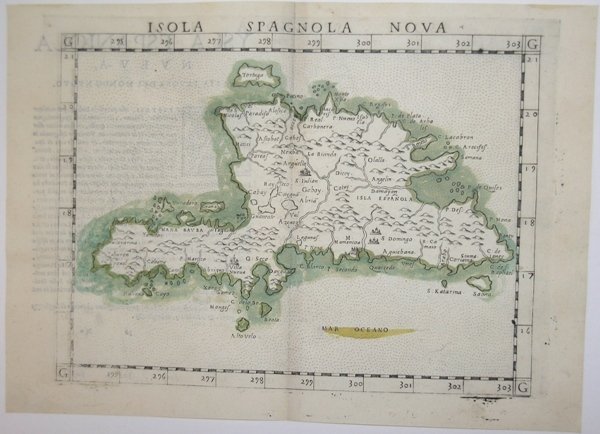
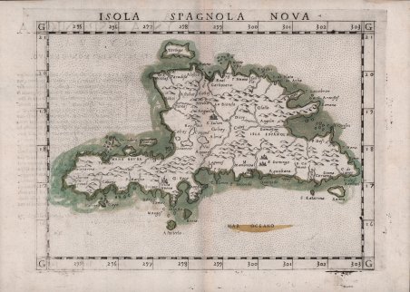
Importante mappa di Girolamo Ruscelli dell’isola di Hispaniola; si basa sulla precedente mappa di Giacomo Gastaldi della stessa regione, datata 1548. Sebbene la forma complessiva e l'orientamento dell'isola non siano del tutto corretti, molti dettagli sono topograficamente accurati. L'isola ha cinque principali catene montuose, tutte delineate nella mappa. Vengono mostrati i principali sistemi fluviali e tutte le città, i paesi, gli insediamenti, le fortificazioni e i porti. Le acque che circondano l'isola sono rese in puntinato. ' Acquaforte e bulino, circa 1561. Magnifica prova, impressa su carta vergata coeva, con margini, in perfetto stato di conservazione. Esemplare in meravigliosa coloritura coeva. Carta tratta dalla ' Geographia di Claudio Tolomeo, a cura di Girolamo Ruscelli, pubblicata in Venezia in più edizioni tra il 1561 ed il 1598. La carta è basata sulla “Geografia” di Giacomo Gastaldi (1548), che probabilmente disegnò personalmente anche queste mappe, che vennero incise dai fratelli Livio e Giulio Sanuto. La peculiarità di queste mappe è che sono incise due per lastra e successivamente tagliate; questo il motivo per cui il segno del rame appare solo in tre lati della mappa. Il testo del Ruscelli e le sue carte sono considerate come il miglior atlante moderno fino alla prima versione del ' Theatrum ' ' Orbis Terrarum ' di Abraham Ortelius (1570). Solo la loro larga diffusione ne impedisce una valutazione sostenuta nel mercato antiquario. L'opera infatti ebbe una prima stesura nel 1561, stampata da Vincenzo Valgrisi che ne curò anche la ristampa del 1562. Tre sono le edizioni firmate da Giordano Ziletti (due nel 1564 e una del 1574), mentre nel 1597 viene edita dai fratelli Calignani. Tutte queste edizioni contengono 64 tavole. Nel 1598 e 1599 vengono alla luce le due edizioni curate da Giuseppe Rosaccio e stampate dagli Eredi di Melchior Sessa. Queste ultime due edizioni comprendono 69 tavole; sono infatti aggiunte la carta del planisfero e dei continenti di Rosaccio. Gli esemplari delle carte del Ruscelli in coloritura coeva sono assolutamente rarissimi. This important Ruscelli map of Hispaniola, is based on Gastaldi’s earlier map of the same region, dated 1548. Although the overall shape and orientation of the island are not entirely correct, many details are topographically accurate. Hispaniola is the second largest island in the West Indies, in the Greater Antilles of the Caribbean Sea. Cuba, Hispaniola, Jamaica, and Puerto Rico are collectively known as the Greater Antilles. These islands are made up of continental rock, as distinct from the Lesser Antilles, which are mostly young volcanic or coral islands. The island has five major mountain ranges, all of which are delineated in the map. Major river systems are shown, and all cities, towns, settlements, fortifications and ports are depicted. The waters surrounding the island are rendered in stipple. Some islands in close proximity to Hispaniola are in place. Christopher Columbus landed on Hispaniola on December 5, 1492 and named it La Isla Española, "The Spanish Island," which was eventually Anglicized to Hispaniola. It is said that when he first laid eyes on its shores, he termed it "La Perle des Antilles”. Hispaniola is the site of the first European settlement in the Americas, La Navidad (1492–1493), as well as the first proper town, La Isabela (1493–1500), and is also the first permanent settlement and current capital of the Dominican Republic, Santo Domingo dating to approximately 1498. Etching with engraving, about 1561. Magnificent proof, printed on contemporary laid paper, with margins, in perfect condition. Example in wonderful contemporary coloring. Map taken from ' Geographia di Claudio Tolomeo ' edited by Girolamo Ruscelli, published in Venice in several editions between 1561 and 1598. The maps is based on the ' Geografia ' by Giacomo Gastaldi (1548), who probably also personally drew these maps, which were engraved by the brothers Livio and Giulio Sanuto. The peculiarity of these maps is that they are engraved two for plate and subsequently cut; this is why the copper sign only appears on three sides of the map. Ruscelli's text and his maps are considered to be the best modern atlas up to the first version of Abraham Ortelius' ' Theatrum Orbis Terrarum ' (1570). Only their widespread diffusion prevents a sustained evaluation in the antiquarian market. In fact, the work had a first edition in 1561, printed by Vincenzo Valgrisi who also edited the 1562 reprint. There are three editions signed by Giordano Ziletti (two in 1564 and one in 1574), while in 1597 it was published by the Calignani brothers. All these editions contain 64 plates. In 1598 and 1599 the two editions edited by Giuseppe Rosaccio and printed by the heirs of Melchior Sessa came to light. These last two editions include 69 plates; in fact, Rosaccio's map of the planisphere and continents has been added. Example of Ruscelli’s maps in contemporary coloring are absolutely rare. Cfr.

 Scopri come utilizzare
 Scopri come utilizzare