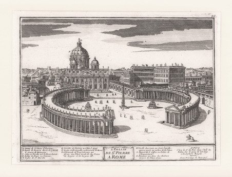
L'Eglise de St. Pierre a Rome
L'Eglise de St. Pierre a Rome | Stampe | DE FER Nicolas


L'Eglise de St. Pierre a Rome
L'Eglise de St. Pierre a Rome | Stampe | DE FER Nicolas
Metodi di Pagamento
- PayPal
- Carta di Credito
- Bonifico Bancario
- Pubblica amministrazione
- Carta del Docente
Dettagli
- Anno di pubblicazione
- 1705
- Formato
- 310 X 235
- Incisori
- DE FER Nicolas
Descrizione
Suggestiva immagine di San Pietro e del Vaticano, con le mura di Roma sullo sfondo. Dall'Atlas Curieux di De Fer. Nicholas de Fer (1646-1720) era il figlio di un venditore di mappe, Antoine de Fer, e crebbe fino a diventare uno dei più noti cartografi in Francia nel XVII secolo. Fu apprendista a dodici anni di Louis Spirinx, un incisore. Quando suo padre morì nel 1673, Nicholas aiutò sua madre a gestire l'attività fino al 1687, quando divenne l'unico proprietario. Il suo primo lavoro conosciuto è una mappa del canale di Languedoc nel 1669, mentre alcune delle sue prime incisioni sono nell'edizione rivista di Methode pour Apprendre Facilement la Geographie (1685). Nel 1697, pubblicò il suo primo atlante mondiale. Forse la sua mappa più famosa è la sua mappa murale dell'America, pubblicata nel 1698, con la sua celebre scena del castoro (incisa da Hendrick van Loon, disegnata da Nicolas Guerard). Dopo la sua morte nel 1720, l'attività passò ai suoi generi, Guillaume Danet e Jacques-Francois Benard. ' Striking image of St Peters and the Vatican, with the walls of Rome in the background. From De Fer's ' Atlas Curieux. Nicholas de Fer (1646-1720) was the son of a map seller, Antoine de Fer, and grew to be one of the most well-known mapmakers in France in the seventeenth century. He was apprenticed at twelve years old to Louis Spirinx, an engraver. When his father died in 1673, Nicholas helped his mother run the business until 1687, when he became the sole proprietor. His earliest known work is a map of the Canal of Languedoc in 1669, while some of his earliest engravings are in the revised edition of ' Methode pour Apprendre Facilement la Geographie ' (1685). In 1697, he published his first world atlas. Perhaps his most famous map is his wall map of America, published in 1698, with its celebrated beaver scene (engraved by Hendrick van Loon, designed by Nicolas Guerard). After his death in 1720, the business passed to his sons-in-law, Guillaume Danet and Jacques-Francois Benard. ' Cfr.
