L'Italie dans son premier etablissement sous la Republique Romaine dans la division par Cesar Auguste et ses differents gouv
L'Italie dans son premier etablissement sous la Republique Romaine dans la division par Cesar Auguste et ses differents gouv | Stampe | CHATELAIN Henri Abraham
L'Italie dans son premier etablissement sous la Republique Romaine dans la division par Cesar Auguste et ses differents gouv
L'Italie dans son premier etablissement sous la Republique Romaine dans la division par Cesar Auguste et ses differents gouv | Stampe | CHATELAIN Henri Abraham
Metodi di Pagamento
- PayPal
- Carta di Credito
- Bonifico Bancario
- Pubblica amministrazione
- Carta del Docente
Dettagli
- Anno di pubblicazione
- 1708
- Luogo di stampa
- Amsterdam
- Formato
- 440 X 340
- Incisori
- CHATELAIN Henri Abraham
- Soggetto
- Carte Storiche
Descrizione
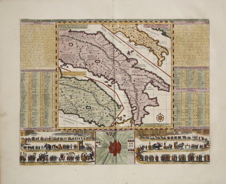
Interessante carta storica dell'Italia centro-meridionale che compara la situazione geografica dell'epoca (primi del '700) con quella risalente all'età di Cesare e quella della prima fase della Repubblica romana. Nei due angoli inferiori, sono incisi un Trionfo d'epoca cesariana e una parata durante giochi e cerimonie. Tratta dall'Atlas Historique, pubblicato ad Amsterdam tra il 1705 e il 1720. Henri Abraham Chatelain (1684 - 1743) era un pastore ugonotto di origini parigine. È meglio conosciuto come cartografo olandese e più specificamente per il suo contributo cartografico nell’Atlas Historique ' in sette volumi, pubblicato ad Amsterdam tra il 1705 e il 1720. Innovativo per il suo tempo, l'Atlas Historique ' combinava incisioni e opere d'arte con studi di geografia, storia, etnologia, araldica e cosmografia. Alcuni studiosi suggeriscono che l'Atlas Historique ' non fu compilato esclusivamente da Henri Chatelain, come si crede comunemente, ma piuttosto fu un'impresa familiare che coinvolse Henri, suo padre Zacharie e suo fratello, sempre Zacharie. Incisione in rame, finemente colorata a mano, in ottimo stato di conservazione. ' Interesting map of Italy, comprising maps of Italy during modern (1720) times, at the time of Cesear and at the time of the commencement of the Roman Republic.The two large vignettes showing a Roman triumph and a parade on the occasion of games and ceremonies. Taken from Chatelain's Atlas Historique, published in Amsterdam between 1705 and 1720. Henri Abraham Chatelain (1684 - 1743) was a Huguenot pastor of Parisian origins. He is best known as a Dutch cartographer and more specifically for his cartographic contribution in the seminal seven volume ' Atlas Historique, published in Amsterdam between 1705 and 1720. Innovative for its time, the ' Atlas Historique ' combined fine engraving and artwork with scholarly studies of geography, history, ethnology, heraldry, and cosmography. Some scholarship suggests that the ' Atlas Historique ' was not exclusively compiled by Henri Chatelain, as is commonly believed, but rather was a family enterprise involving Henri, his father Zacharie and his brother, also Zacharie. Copper engraving, fine later hand colour, in excellent condition. Higly decorative. Cfr.
