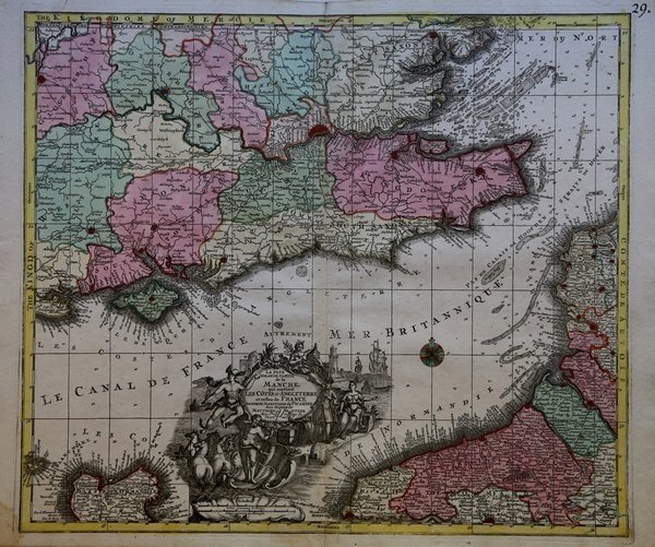
La plus grande partie de la Manche qui contient les Cotes d’Angleterre et celles de France.
La plus grande partie de la Manche qui contient les Cotes d’Angleterre et celles de France. | Stampe | SEUTTER "il vecchio" Matthaus

La plus grande partie de la Manche qui contient les Cotes d’Angleterre et celles de France.
La plus grande partie de la Manche qui contient les Cotes d’Angleterre et celles de France. | Stampe | SEUTTER "il vecchio" Matthaus
Metodi di Pagamento
- PayPal
- Carta di Credito
- Bonifico Bancario
- Pubblica amministrazione
- Carta del Docente
Dettagli
- Anno di pubblicazione
- 1730
- Luogo di stampa
- Augsburg
- Formato
- 580 X 495
- Incisori
- SEUTTER "il vecchio" Matthaus
Descrizione
Carta geografica del canale della Manica raffigurante le coste meridionale dell’Inghilterra, con l’isola di Wight, e le coste settentrionali della Normandia. Bellissimo il cartiglio al centro. Matthäus Seutter (1678 - 1757) fu uno dei più importanti e prolifici editori tedeschi di mappe del XVIII secolo. Attivo, come incisore sotto la tutela dell'importante J. B. Homann. All'inizio del 1700 Seutter lasciò Homann per tornare ad Augusta, dove lavorò per l'importante editore d'arte Jeremia Wolff (1663 - 1724), per il quale incise mappe e altre stampe. Intorno al 1717 fondò la propria casa editrice cartografica indipendente ad Augusta. La maggior parte delle mappe di Seutter sono pesantemente basate, se non addirittura copie, di lavori precedenti fatti dalle calcografie Homann e De L'Isle. Ciononostante, dal 1731/32 Seutter era uno degli editori più prolifici del suo tempo e fu onorato dall'imperatore tedesco Carlo VI che gli diede il titolo di Geografo Imperiale, dopo il quale la maggior parte delle mappe successive includeva la denominazione ' Avec Privilege. ' Seutter continuò a pubblicare fino alla sua morte, all'apice della sua carriera, nel 1757. Incisione in rame, coloritura coeva, in eccellente stato di conservazione. Molto decorativa. Map of the English Channel showing the southern coast of England, the Isle of Wight, and the northern coast of Normandy. Wonderful folio sheet map of the English Channel. A highly decorative c. 1730 map of the english Channel, southeastern england, and the coasts of Normandy by Matthius Seutter. The map covers southeastern england, including London and the full length of the Thames River, from Gloucester and Salisbury to the Straits of Dover and from Oxfordshire to the Isle of Wight. The coasts of Normandy are covered from Calais to Havre De Grace. Seutter's map combines elements of both nautical charts and traditional maps, with depth soundings and shading to indicate undersea dangers throughout the english Channel, North Sea, and Straits of Dover. An elaborate allegorical title cartouche appears at bottom center and is decorated with maritime scenes, castles, a merchant, a beehive and mythological characters including Neptune and Hermes. The cartouche features Greek deities including Poseidon and Hermes, as well as merchants, honey bees, and trade vessels.This map first appeared in various Seutter composite atlases in the 1730s. The present example is exceptionally vivid, suggesting an early impression from the plate. The plate was subsequently updated and reused by Seutter's successor, Conrad Lotter, in the 1770s. Mattha?us Seutter (1678 - 1757) was one of the most important and prolific German map publishers of the 18th century. Seutter was born the son of a goldsmith but apprenticed as a brewer. Apparently uninspired by the beer business, Seutter abandoned his apprenticeship and moved to Nuremberg where he apprenticed as an engraver under the tutelage of the prominent J. B. Homann. Sometime in the early 1700s Seutter left Homann to return to Augsburg, where he worked for the prominent art publisher jeremiad Wolff (1663 - 1724), for whom he engraved maps and other prints. Most of Seutter's maps are heavily based upon, if not copies of, earlier work done by the Homann and De L'Isle firms. Nonetheless, by 1731/32 Seutter was one of the most prolific publishers of his time and was honored by the German Emperor Karl VI who gave him the title of Imperial Geographer, after which most subsequent maps included the ' Avec Privilege ' designation. Copper engraving, original colouring, in excellent condition. Cfr.
