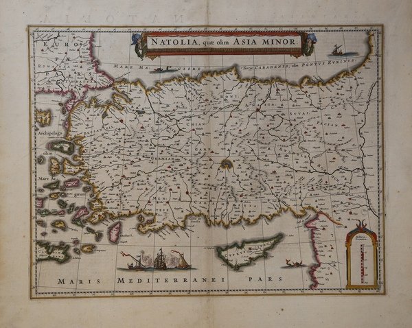
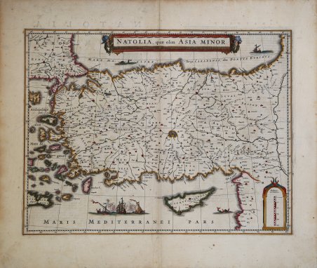
Natolia, quae olim Asia Minor
Natolia, quae olim Asia Minor | Stampe | JANSSONIUS Johannes

Natolia, quae olim Asia Minor
Natolia, quae olim Asia Minor | Stampe | JANSSONIUS Johannes
Metodi di Pagamento
- PayPal
- Carta di Credito
- Bonifico Bancario
- Pubblica amministrazione
- Carta del Docente
Dettagli
- Anno di pubblicazione
- 1640
- Luogo di stampa
- Amsterdam
- Formato
- 500 X 390
- Incisori
- JANSSONIUS Johannes
Descrizione
Carta geografica tratta dall'Atlas Major, di Jannsonius, circa 1640.La mappa copre laTurchia dal Mar Egeo orientale fino al fiume Eufrate. Sono riportate anche Cipro e alcune delle isole del Mar Egeo, nonché le importanti città di Costantinopoli (Istanbul), Smirne (Izmir) e Antiochia.Nel mar Mediterraneo è illustrata una delle tante battaglie navali combattute dagli Ottomani. Un banner titolo splendidamente inciso adorna la parte superiore della mappa, con una scala raffigurato nel quadrante in basso a destra, e l'illustrazione di una figura turbante tenendo la scala. Joannes Janssonius, figlio dell'editore di Arnhem Jan Janssen, sposò Elisabeth Hondius, figlia di Jodocus Hondius, ad Amsterdam nel 1612. Dopo il suo matrimonio, si stabilì in questa città come libraio ed editore di materiale cartografico. Nel 1618 si stabilì ad Amsterdam accanto alla libreria di Willem Jansz. Blaeu, entrando in una seria competizione. Le sue attività non riguardavano solo la pubblicazione di atlanti e libri, ma anche di mappe singole e un vasto commercio di libri con filiali a Francoforte, Danzica, Stoccolma, Copenaghen, Berlino, Koningsbergen, Ginevra e Lione. Nel 1631 iniziò a pubblicare atlanti insieme a Henricus Hondius. Nei primi anni 1640 Henricus Hondius lasciò l'attività di pubblicazione di atlanti completamente a Janssonius. La concorrenza con Joan Blaeu, figlio e successore di Willem, nella produzione di atlanti spinse Janssonius ad ampliare il suo ' Atlas Novus ' finalmente in un'opera di sei volumi, in cui furono inseriti un atlante marino e un atlante del Vecchio Mondo. Dopo la morte di Joannes Janssonius, il negozio e la casa editrice furono continuati dagli eredi sotto la direzione di Johannes van Waesbergen (c. 1616-1681), genero di Joannes Janssonius. Le matrici degli atlanti di Janssonius furono in seguito vendute a Schenk e Valck. Incisione in rame, coloritura coeva, in ottimo stato di conservazione. The map covers Turkey from the Aegean Sea east as far as the Euphrates River. Cyprus and some of the Aegean Islands are also included. The important cities of Constantinople (Istanbul), Smyrna (Izmir) and Antioch are identified. A beautifully illustrated sea battle in the Mediterranean depicts one of the many naval battles fought by the Ottomans. Another illustration of a sea monster is also featured in the bottom right quadrant. From the Latin edition of the Atlas Major. Joannes Janssonius (Arnhem, 1588-1664), son of the Arnhem publisher Jan Janssen, married Elisabeth Hondius, daughter of Jodocus Hondius, in Amsterdam in 1612. After his marriage, he settled down in this town as a bookseller and publisher of cartographic material. In 1618 he established himself in Amsterdam next door to Blaeu’s book shop. He entered into serious competition with Willem Jansz. Blaeu. His activities not only concerned the publication of atlases and books, but also of single maps and an extensive book trade with branches in Frankfurt, Danzig, Stockholm, Copenhagen, Berlin, Koningsbergen, Geneva, and Lyon. In 1631 he began publishing atlases together with Henricus Hondius. In the early 1640s Henricus Hondius left the atlas publishing business completely to Janssonius. Competition with Joan Blaeu, Willem’s son and successor, in atlas production prompted Janssonius to enlarge his ' Atlas Novus ' finally into a work of six volumes, into which a sea atlas and an atlas of the Old World were inserted. After the death of Joannes Janssonius, the shop and publishing firm were continued by the heirs under the direction of Johannes van Waesbergen (c. 1616-1681), son-in-law of Joannes Janssonius. The copperplates from Janssonius’s atlases were afterwards sold to Schenk and Valck. Copperplate with original hand colour, in very good conditions. Cfr.
