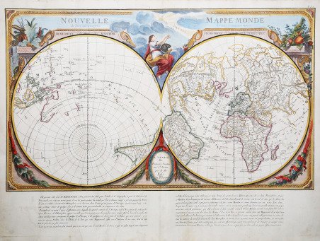
Nouvelle Mappe Monde dedièe au progrès de nos connoissances
Nouvelle Mappe Monde dedièe au progrès de nos connoissances | Stampe | SANTINI Francesco & Paolo

Nouvelle Mappe Monde dedièe au progrès de nos connoissances
Nouvelle Mappe Monde dedièe au progrès de nos connoissances | Stampe | SANTINI Francesco & Paolo
Metodi di Pagamento
- PayPal
- Carta di Credito
- Bonifico Bancario
- Pubblica amministrazione
- Carta del Docente
Dettagli
- Anno di pubblicazione
- 1776
- Luogo di stampa
- Venezia
- Formato
- 680 X 490
- Incisori
- SANTINI Francesco & Paolo
Descrizione
Mappamondo scientifico a due emisferi, splendidamente inciso. La mappa è realizzata considerando come primo meridiano quello che attraversa Parigi. I due emisferi sono ruotati di 45 gradi sul loro asse in modo da delimitare in uno le acque, nell’altro le terre. Questo effetto crea un “Emisfero Terrestre” con gli stati dell’emisfero settentrionale, l’Africa e buona parte del Sud America, mentre l’ “Emisfero Marino” mostra le Indie Orientali, l’Australasia e il Pacifico, nonché l’estremità meridionale del Sud America.Non sorprende il fatto che, come conseguenza della sperimentazione attuata dalla scuola francese di cartografi teoretici, Parigi si trovi "precisement au centre de tous les continents du monde." Questa proiezione insolita, ispirata al lavoro della Reale Accademia delle Scienze Francese , enfatizza anche la continuità dei continenti. Questo tema è in linea con le primissime opere realizzate dai cartografi francesi scientifici, tra cui Philippe Buache, e riprende i tipici concetti teoretici, tra cui il 'Mer de l'Ouest' ed altri fantastici sistemi visibili nell’America nord-occidentale.Il mappamondo fu pubblicato per la prima volta a Parigi da Julien nel 1753. Questo esemplare, nello specifico, è una successiva edizione italiana pubblicata a Venezia da Santini e Remondini. La mappa, inserita in un’elaborata cornice decorativa, è completata da paragrafi di testo in francese che ne spiegano i dettagli, perciò Santini poté nominare i due emisferi Marino e Terrestre. Australia e Nuova Zelanda sono raffigurate solo in parte (nonostante le scoperte di Cook un decennio prima); il fittizio 'Mer de l'Ouest' si trova nell'america nord-occidentale, con un grande 'I. Nouvelle' esattamente a sud dello stretto di Bering; inoltre, Jesso è rappresentata come parte della terra ferma in Asia. Carta geografica curata da don Paolo Santini e dal fratello Francesco per il loro prestigioso Atlas universel dressé sur les meilleures cartes modernes, sontuoso atlante composto da mappe che rielaborano la più aggiornata cartografia francese in una veste veneta. Le carte sono prese dai migliori geografi del suo tempo, D’Anville, Bellin, Bonne, Borgomo, Boscovich, Clarici, Delisle, Jaillot, Janvier, Robert de Vaugondy. ' In effetti nelle carte dei Santini, vengono mescolati termini francesi con italiani, ma sono offerte con una grazia compositiva ed incisoria loro caratteristiche: una toponomastica non fitta, scritta in grande e ben leggibile. L’atlante di Santini non ebbe una grande fortuna editoriale e uscì in poche copie: venne quindi ristampato dai Remondini, che avevano acquistato dal Santini nel 1781 le incisioni in rame. Alle carte di Paolo Santini, datate fra il 1774 e il 1780, i Remondini aggiunsero diverse altre carte, datate fra il 1782 e il 1784: fra queste, nel secondo volume, la grande carte ripiegata dell’Italia, la Repubblica di Genova, la Palestina, le grandi carte dell’Africa. Paolo Santini (1729, Venezia–1793, Belluno), sacerdote cattolico presso la Chiesa di Santa Maria Formosa a Venezia, docente di disegno alle scuole della città lagunare della Provincia Veneta della Compagnia di Gesù. Santini, cartografo, incisore ed editore, aggiornò e pubblicò le mappe dei geografi e cartografi francesi Gilles Robert de Vaugondy (1688–1766) e Didier Robert de Vaugondy (c. 1723–1786), ispirandosi anche alle opere dei cartografi italiani, innanzitutto a quelle di Giovanni Antonio Rizzi Zannoni (1736–1814). Utilizzando, come modello, le mappe raccolte e pubblicate nel 1752 nell’Atlas Universel di Gilles Robert e Didier Robert de Vaugondy, acquistate a Parigi da suo fratello, Francesco Santini, e le «migliori carte geografiche» dell’epoca, Paolo Santini incise nuove lastre e diede alle stampe a Venezia, nel 1776, l’Atlas Universel dressé sur les meilleures cartes modernes. L’anno successivo, 1777, cedette i diritti di pubblicazione all’editore Giuseppe Remondini (1754?. A finely engraved scientific double hemisphere world map, constructed with the prime meridian through Paris . The hemispheres are rotated on their axis through 45 degrees in order to define one watery, the other land. This effect creates the 'Hemisphere Terrestre' with the countries of the northern hemisphere, Africa and most of South America, while the 'Hemisphere Maritime' shows the East Indies, Australasia and the Pacific, and the southern tip of South America. Not surprisingly, as a consequence of this experiment from France's school of theoretical cartographers, Paris appears "precisement au centre de tous les continents du monde." This unusual projection, based on the work of the French Academie Royale des Sciences, also emphasises the continuity of the continents. This is a theme in keeping with the earlier work by French scientific map-makers, including Philippe Buache, and repeats typical theoretical concepts such as the 'Mer De L'Ouest' and the other fanciful water systems apparent in north-west America. The map was first published in Paris by Julien in 1753. This particular example is a later Italian edition published in Venice by Santini and Remondini. The map, set within an elaborate framework design, sits above paragraphs of French text explaining the projection. Thus Santini could name the two halves 'Hemisphere Maritime' and 'Hemisphere Terrestre'. Australia and New Zealand are only shown partially (despite Cook a decade before); the erroneous 'Mer de L'Ouest' appears in northwest America , with a large 'I. Nouvelle' just south of the Bering Straits; and Jesso is part of mainland Asia. Map compiled by Don Paolo Santini and his brother Francesco, for their prestigious Atlas universel dressé sur les meilleures cartes modernes, a sumptuous Atlas composed of maps that rework the most up-to-date French cartography in a Venetian guise. The maps are taken from the best geographers of his time, D'Anville, Bellin, Bonne, Borgomo, Boscovich, Clarici, Delisle, Jaillot, Janvier, Robert de Vaugondy. ' Indeed, in Santini's maps, French terms are mixed with Italian, but they are offered with a compositional and engraving grace that is characteristic of them: an uncluttered toponymy, written large and clearly legible. Santini's Atlas did not have great publishing success and came out in few copies: it was then reprinted by the Remondini, who had purchased the copperplates from Santini in 1781. To Paolo Santini's maps, dated between 1774 and 1780, the Remondini added several other maps, dated between 1782 and 1784: among them, in the second volume, the large folded maps of Italy, the Republic of Genoa, Palestine, and the large maps of Africa. Paolo Santini (1729, Venice-1793, Belluno), Catholic priest at the Church of Santa Maria Formosa in Venice, professor of drawing at schools in the Lagooon city of the Venetian Province of the Society of Jesus. Santini, a cartographer, engraver and publisher, updated and published the maps of French geographers and cartographers Gilles Robert de Vaugondy (1688-1766) and Didier Robert de Vaugondy (c. 1723-1786), also drawing inspiration from the works of Italian cartographers, first and foremost those of Giovanni Antonio Rizzi Zannoni (1736-1814). Using, as a model, the maps collected and published in 1752 in the Atlas Universel by Gilles Robert and Didier Robert de Vaugondy, purchased in Paris by his brother, Francesco Santini, and the "best maps" of the time, Paolo Santini engraved new plates and gave to the presses in Venice, in 1776, the Atlas Universel dressé sur les meilleures cartes modernes. The following year, 1777, he sold the publishing rights to publisher Giuseppe Remondini (1754-1811) of Bassano del Grappa, who reprinted the "Atlas Universel" in two volumes that collected a total of 123 maps. The copper plates in the Santini's possession were later purchased, in 1781, by the Remondini printing house. Copperplate engraving, original outline coloring, in excellent conditi. Cfr.
