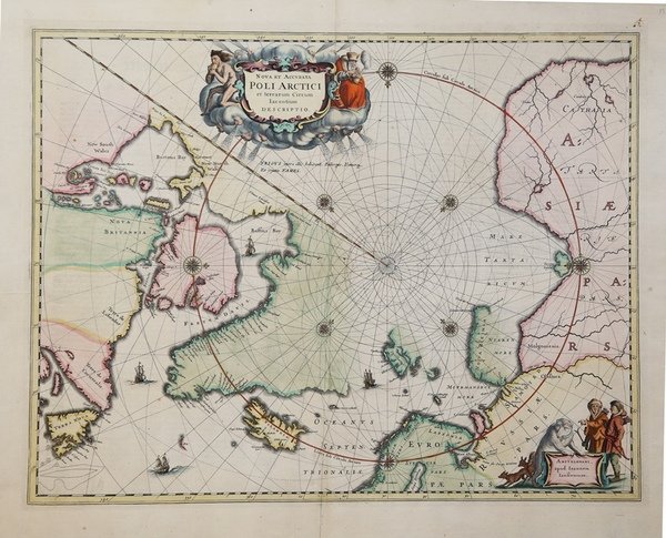
Nova et Accurata Poli Artici et Terrarum Circum Iacentium Descriptio
Nova et Accurata Poli Artici et Terrarum Circum Iacentium Descriptio | Stampe | JANSSONIUS Johannes

Nova et Accurata Poli Artici et Terrarum Circum Iacentium Descriptio
Nova et Accurata Poli Artici et Terrarum Circum Iacentium Descriptio | Stampe | JANSSONIUS Johannes
Metodi di Pagamento
- PayPal
- Carta di Credito
- Bonifico Bancario
- Pubblica amministrazione
- Carta del Docente
Dettagli
- Anno di pubblicazione
- 1637
- Luogo di stampa
- Amsterdam
- Formato
- 540 X 420
- Incisori
- JANSSONIUS Johannes
- Soggetto
- Terre Artiche
Descrizione
Questa bella mappa, pubblicata originariamente nel 1637, alla fine sostituì la mappa di Hondius del Polo Nord e divenne il prototipo per molte mappe successive, comprese quelle di Blaeu. La mappa incorpora le scoperte fatte dal capitano Thomas James lungo le coste meridionali e occidentali della Baia di Hudson nel 1631-2. La delineazione sulla costa artica della Russia è derivata dalle informazioni dell'esplorazione di Willem Barents del 1596-7. L'esploratore inglese Hugh Willoughby ha una piccola isola che porta il suo nome al largo della costa della Lapponia (Sir Hugo Willoughby's Landt). Willoughby capitanò una spedizione di tre navi per trovare un passaggio a nord-est nel 1553, ma due delle navi furono strappate via durante una tempesta. Willoughby e il suo equipaggio delle due navi morirono e furono ritrovati sulla Novaya Zemlja l'anno seguente, con il suo diario. La terza nave con il suo comandante in seconda Richard Chancellor arrivò in Russia. ' Le linee lossodromiche si irradiano dal Polo Nord e diverse rose di bussole abbelliscono la carta. Un grande cartiglio del titolo, con due figure e numerose teste di vento, nasconde convenientemente la costa nord-occidentale dell'America. La carta è ulteriormente decorata con navi e un cartiglio con l'imprint di Jansson, che raffigura uomini in parka, un orso polare e volpi. Questo esemplare è il quarto stato della lastra con Nova Zemlja collegata alla terraferma con un ponte terrestre e la costa di Spitzbergen completata. ' Joannes Janssonius, figlio dell'editore di Arnhem Jan Janssen, sposò Elisabeth Hondius, figlia di Jodocus Hondius, ad Amsterdam nel 1612. Dopo il suo matrimonio, si stabilì in questa città come libraio ed editore di materiale cartografico. Nel 1618 si stabilì ad Amsterdam accanto alla libreria di Willem Jansz. Blaeu, entrando in una seria competizione. Le sue attività non riguardavano solo la pubblicazione di atlanti e libri, ma anche di mappe singole e un vasto commercio di libri con filiali a Francoforte, Danzica, Stoccolma, Copenaghen, Berlino, Koningsbergen, Ginevra e Lione. Nel 1631 iniziò a pubblicare atlanti insieme a Henricus Hondius. Nei primi anni 1640 Henricus Hondius lasciò l'attività di pubblicazione di atlanti completamente a Janssonius. La concorrenza con Joan Blaeu, figlio e successore di Willem, nella produzione di atlanti spinse Janssonius ad ampliare il suo Atlas Novus finalmente in un'opera di sei volumi, in cui furono inseriti un atlante marino e un atlante del Vecchio Mondo. Dopo la morte di Joannes Janssonius, il negozio e la casa editrice furono continuati dagli eredi sotto la direzione di Johannes van Waesbergen (c. 1616-1681), genero di Joannes Janssonius. Le matrici degli atlanti di Janssonius furono in seguito vendute a Schenk e Valck. Incisione in rame, bellissima coloritura coeva, ottimo stato di conservazione. This beautiful map, originally published in 1637, eventually replaced Hondius' map of the North Pole and became the prototype for many later maps including those of Blaeu. This map incorporates the discoveries made by Captain Thomas James along the southern and western shores of Hudson Bay in 1631-2. The delineation on Russia's Arctic coast is derived from the information from Willem Barents' exploration of 1596-7. The English explorer Hugh Willoughby has a small island named after him off the coast of Lapland (Sir Hugo Willoughby's Landt). Willoughby captained an expedition of three ships to find a Northeast Passage in 1553, but two of the ships were ripped away during a storm. Willoughby and his crew from the two ships died and were found on Novaya Zemla the following year, with his journal. The third ship with his second-in-command Richard Chancellor made it to Russia. Rhumb lines radiate from the North Pole and several compass roses embellish the chart. A large title cartouche, with two figures and numerous wind heads, conveniently hide the northwest coast of America. Joannes Janssonius (Arnhem, 1588-1664), son of the Arnhem publisher Jan Janssen, married Elisabeth Hondius, daughter of Jodocus Hondius, in Amsterdam in 1612. After his marriage, he settled down in this town as a bookseller and publisher of cartographic material. In 1618 he established himself in Amsterdam next door to Blaeu’s book shop. He entered into serious competition with Willem Jansz. Blaeu. His activities not only concerned the publication of atlases and books, but also of single maps and an extensive book trade with branches in Frankfurt, Danzig, Stockholm, Copenhagen, Berlin, Koningsbergen, Geneva, and Lyon. In 1631 he began publishing atlases together with Henricus Hondius. In the early 1640s Henricus Hondius left the atlas publishing business completely to Janssonius. Competition with Joan Blaeu, Willem’s son and successor, in atlas production prompted Janssonius to enlarge his Atlas Novus finally into a work of six volumes, into which a sea atlas and an atlas of the Old World were inserted. After the death of Joannes Janssonius, the shop and publishing firm were continued by the heirs under the direction of Johannes van Waesbergen (c. 1616-1681), son-in-law of Joannes Janssonius. The copperplates from Janssonius’s atlases were afterwards sold to Schenk and Valck. The map is further decorated with ships and a cartouche with Jansson’s imprint, which depicts men in parkas, a polar bear and foxes. This example is the fourth state of the plate with Nova Zemla connected to the mainland with a land bridge and the completed coastline of Spitzbergen. German text on verso. Very good condition. Cfr.
