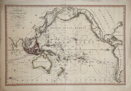
Océanie ou Australasie et Polynésie
Océanie ou Australasie et Polynésie | Stampe | LAPIE Pierre Marie
Océanie ou Australasie et Polynésie
Océanie ou Australasie et Polynésie | Stampe | LAPIE Pierre Marie
Metodi di Pagamento
- PayPal
- Carta di Credito
- Bonifico Bancario
- Pubblica amministrazione
- Carta del Docente
Dettagli
- Anno di pubblicazione
- 1817
- Luogo di stampa
- Parigi
- Formato
- 790 X 540
- Incisori
- LAPIE Pierre Marie
- Soggetto
- Pacifico e Oceania
Descrizione
Rara carta di grandi dimensioni dell'Oceano Pacifico di Pierre Marie Lapie, pubblicata nel 1817. In alto a sinistra: Oceanie ou Australasie et Polynesie / par Lapie; gravee par Blondeau graveur du Roi et premier graveur du Depot de la Guerre a Paris: Chez Basset Md. d'Estampes rue St. Jacques no. 64, 1817. Mostra il mondo durante l'età delle esplorazioni, ripercorrendo gli ambiziosi viaggi dei grandi navigatori quali Magellano, Cook e Vancouver. Lapie, in qualità di geografo del re Luigi XVIII, presenta un lavoro preciso e artistico al tempo stesso, con caratteristiche topografiche, rotte marittime e confini politici articolati con chiarezza e colori sottili. La calligrafia meticolosa, soprattutto nel titolo e nelle legende, rispecchia le caratteristiche di stile della Francia del primo Ottocento. Le rotte minuziosamente rappresentate nella mappa includono i viaggi di: Magellano 1521; Bering 1741; Anson 1743; Byron 1765; Bougainville 1769; Cook, 1773, 1769, 1777, 1778; Furneau, 1773; Clerke 1780; La Perouse 1786; Marchang 1791; La Recherche 1792, 1795; Vancouver 1791, 1793, 1794; Flinders 1803; Krusenstern, 1804, 1805. Pierre M. Lapie (nato nel 1779 e morto nel 1850) e suo figlio Alexandre Emile Lapie (nato nel 1809 e morto nel 1850) furono cartografi e incisori francesi attivi nella prima parte del XIX secolo. I Lapie erano ufficiali dell'esercito francese, rispettivamente colonnello e capitano. Alexander si fregiava del titolo di “Primo Geografo del Re”, titolo che compare su molti dei suoi atlanti. Sia il padre che il figlio erano incisori eccezionali e cartografi esigenti. Lavorando separatamente e congiuntamente, pubblicarono quattro importanti atlanti: l'Atlante dell'Impero francese del 1811 (Alexander), ' l'Atlas Classique et Universel ' del 1812 (Pierre), l'Atlas Universel de Geographie Ancienne et Modern ' (edizione congiunta) e ' l'Atlas Militaire ' del 1848 (Alexander). Acquaforte, finemente colorata a mano, in ottimo stato di conservazione. Rare large chart of the Pacific Ocean by Pierre Marie Lapie, published in 1817. At the top left: Oceanie ou Australasie et Polynesie / par Lapie; gravee par Blondeau graveur du Roi et premier graveur du Depot de la Guerre a Paris: Chez Basset Md. d'Estampes rue St. Jacques no. 64, 1817 Shows the world during the Age of Exploration, tracing the ambitious voyages of explorers like Magellan, Cook and Vancouver. Lapie, as geographer to the King Louis XVIII, presents work that is both precise and artistic, with topographical features, sea-routes and political boundaries articulated with clarity and subtle coloration. Meticulous calligraphy, especially in the title and legends, showcases the stylistic preferences of early 19th-century France. Routes include the voyages of: Magellan 1521; Bering 1741; Anson 1743; Byron 1765; Bougainville 1769; Cook, 1773, 1769, 1777, 1778; Furneau, 1773; Clerke 1780; La Perouse 1786; Marchang 1791; La Recherche 1792, 1795; Vancouver 1791, 1793, 1794; Flinders 1803; Krusenstern, 1804, 1805. Pierre M. Lapie (fl. 1779 - 1850) and his son Alexandre Emile Lapie (fl. 1809 - 1850) were French cartographers and engravers active in the early part of the 19th century. The Lapies were commissioned officers in the French army holding the ranks of Colonel and Capitan, respectively. Alexander enjoyed the title of "First Geographer to the King", and this title appears on several of his atlases. Both father and son were exceptional engravers and fastidious cartographers. Working separately and jointly they published four important atlases, an 1811 Atlas of the French Empire (Alexander), the 1812 ' Atlas Classique et Universel ' (Pierre), the ' Atlas Universel de Geographie Ancienne et Modern ' (joint issue), and the 1848 ' Atlas Militaire ' (Alexander). They also issued many smaller maps and independent issues. Etching with fine original hand colour, good condition. Cfr.
