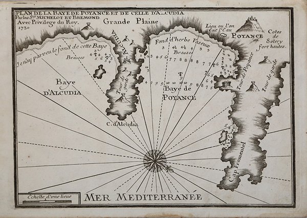
Plan de la Baye de Poyance et de celle d'Alcudia
Plan de la Baye de Poyance et de celle d'Alcudia | Stampe | MICHELOT & Laurent BREMOND Henry

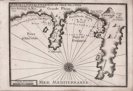
Plan de la Baye de Poyance et de celle d'Alcudia
Plan de la Baye de Poyance et de celle d'Alcudia | Stampe | MICHELOT & Laurent BREMOND Henry
Metodi di Pagamento
- PayPal
- Carta di Credito
- Bonifico Bancario
- Pubblica amministrazione
- Carta del Docente
Dettagli
- Anno di pubblicazione
- 1727
- Luogo di stampa
- Marsiglia
- Formato
- 255 X 185
- Incisori
- MICHELOT & Laurent BREMOND Henry
Descrizione
Carta nautica tratta dal raro ' Recueil de Plusiereurs Plans des Ports et Rades de la Mer Mediterranée Dediée A Monseigneur le Grand Prieur de France, General des Galeres Levé et Dessigné sur les Lieux par les Srs. Michelot Hydrographe et Pilote Real des Galeres du Roy et Bremond Hydrographe du Roy et de la Ville, avec Pri.ge Du Roy ' (1727), atlante nautico di 37 tavole, stampato a Marsiglia. ' I piani nautici sono incisi da Pieter Starckman, uno dei più attivi intagliatori dell’epoca, collaboratore di molti cartografi ed editori. ' Secondo Shirley [cfr. ' Maps in the Atlases of the British Library, p. 1234] la prima edizione dell’opera contiene 21 tavole, mentre la ristampa, senza data, contiene 37 tavole delle quali alcune datate 1730. La terza, e ultima, contiene 38 tavole e reca la data 1732. Henry Michelot, dopo il successo riscosso con la pubblicazione della sua guida nautica ' Le Portulan de Partie de la Mer Méditerranée, ou Le vray Guide des Pilotes Costiers ' (1703), si unì a Laurent Bremond. All’inizio del XVIII secolo Henry Michelot e Laurens Bremond pubblicarono due importanti atlanti nautici del Mediterraneo e piani nautici ampiamente utilizzati dai naviganti costieri. Le carte sono interessanti e importanti per l’attendibilità derivata dall’esperienza di Michelot che, a differenza dei successivi “geografi del Dépôt des cartes et plans de la Marine” come Jacques-Nicolas Bellin, ha avuto una lunga esperienza in mare. Il primo atlante prodotto contiene 16 carte, su piccola scala, del Mediterraneo e della costa atlantica in prossimità dello stretto di Gibilterra, integrate da una o più profili costieri. Le date delle carte sono comprese tra il 1715 e il 1726; in questo periodo Michelot si firmava come ' Hydrographe et Pilote Real des Galères du Roy ' (idrografo e pilota della cambusa reale per il corpo della galea dei re). Poco si sa del co-creatore dell’opera Laurent Bremond. Nella raccolta nautica il suo nome succede sempre a quello di Michelot, e viene qualificato come ' Hydrographe du Roy et de la Ville ' (idrografo del re e della città). Bremond sembrerebbe essere stato l’editore e il venditore della raccolta nautica, la forza commerciale della società; titolare di una sorta di negozio vicino al porto. Tutte le carte sono chiaramente contrassegnate: ' Ce vendent a Marseille chez Laurens Bremond sur le Port au coin de Reboul ' (venduto a Marsiglia da Laurens Bremond nel porto all’angolo di Reboul). Incisione in rame, in ottimo stato di conservazione. Bibliografia S. Bifolco, ' Mare Nostrum ' (2019), pp. 270-271, tav. 122; Palau, 168325. Tooley, 438,80. Nautical chart taken from the rare ' Recueil de Plusiereurs Plans des Ports et Rades de la Mer Mediterranée Dediée A Monseigneur le Grand Prieur de France, General des Galeres Levé et Dessigné sur les Lieux par les Srs. Michelot Hydrographe et Pilote Real des Galeres du Roy et Bremond Hydrographe du Roy et de la Ville, avec Pri.ge Du Roy ' (1727), nautical atlas of 37 plates, printed in Marseilles. The nautical plans are engraved by Pieter Starckman, one of the most active engravers of the time, collaborator of many cartographers and publishers. According to Shirley [see ' Maps in the Atlases of the British Library, p. 1234] the first edition of the work contains 21 plates, while the reprint, undated, contains 37 plates, some of which are dated 1730. The third and last edition contains 38 plates and is dated 1732. Henry Michelot, after the success achieved with the publication of his nautical guide ' Le Portulan de Partie de la Mer Méditerranée, ou Le vray Guide des Pilotes Costiers ' (1703), joined Laurent Bremond. In the early 18th century Henry Michelot and Laurens Bremond published two important nautical atlases of the Mediterranean and nautical plans widely used by coastal mariners. The charts are interesting and important for the reliability derived from the experience of Michelot who, unlike later "geographers of the Dépôt des cartes et plans de la Marine" such as Jacques-Nicolas Bellin, had long experience at sea. The first atlas produced contains 16 maps, on a small scale, of the Mediterranean and the Atlantic coast near the Strait of Gibraltar, supplemented by one or more coastal profiles. The dates of the charts are between 1715 and 1726; at this time Michelot signed himself as ' Hydrographe et Pilote Real des Galères ' du Roy ' (hydrographer and pilot of the royal galley for the kings' galley corps). Little is known about the co-creator of the work Laurent Bremond. In the nautical collection his name always succeeds that of Michelot, and he is qualified as ' Hydrographe du Roy et de la Ville ' (hydrographer of the king and the city). Bremond would seem to have been the publisher and seller of the nautical collection, the commercial force of the company; owner of a sort of store near the port. All charts are clearly marked: ' Ce vendent a Marseille chez Laurens Bremond sur le Port au coin de Reboul ' (sold in Marseille by Laurens Bremond in the port at the corner of Reboul). Copper engraving, in excellent condition. Literature S. Bifolco, ' Mare Nostrum ' (2019), pp. 270-271, tav. 122; Palau, 168325. Tooley, 438.80. Cfr.
