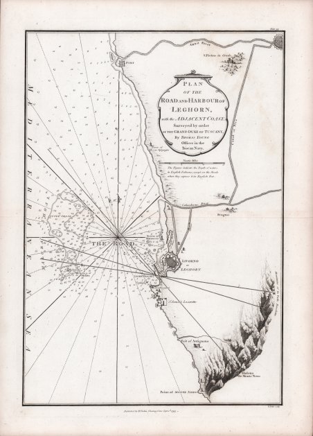
Plan of the Road and Harbour of Leghorn
Plan of the Road and Harbour of Leghorn | Stampe | FADEN William
Plan of the Road and Harbour of Leghorn
Plan of the Road and Harbour of Leghorn | Stampe | FADEN William
Metodi di Pagamento
- PayPal
- Carta di Credito
- Bonifico Bancario
- Pubblica amministrazione
- Carta del Docente
Dettagli
- Anno di pubblicazione
- 1793
- Luogo di stampa
- Londra
- Formato
- 230 X 335
- Incisori
- FADEN William
Descrizione
Rara carta nautica dei dintorni di Livorno, stampata a Londra da William Faden nel 1793 ed inclusa in Le Petit Neptune Francais; or, French Coasting Pilot for the Coast of Flanders, Channel, Bay of Biscay and Mediterranean, to Which is Added, the Coast of Italy from the River Var to Orbitello; with the Gulf of Naples, and the Island of Corsica. L'opera fu pubblicata come risposta agli sconvolgimenti rivoluzionari in Francia, in previsione della guerra con la Francia. “Many of the charts in Faden's Le Petit Neptune follow those in Thomas Jeffery's atlas of the same name of thirty years' earlier. They are however newly engraved with Faden's imprint. and a plate number in the upper right corner" (Shirley). Rare nautical chart of the surroundings of Livorno, printed in London by William Faden in 1793 and included in Le Petit Neptune Francais; or, French Coasting Pilot for the Coast of Flanders, Channel, Bay of Biscay and Mediterranean, to Which is Added, the Coast of Italy from the River Var to Orbitello; with the Gulf of Naples, and the Island of Corsica. “Many of the charts in Faden's Le Petit Neptune follow those in Thomas Jeffery's atlas of the same name of thirty years' earlier. They are however newly engraved with Faden's imprint. and a plate number in the upper right corner" (Shirley). The work was issued as a response to the revolutionary upheavals in France, in anticipation of war with France. Cfr.
