Ragionevole Forma et Vera Postura del' Isola di Negroponte
Ragionevole Forma et Vera Postura del' Isola di Negroponte | Stampe | FERRETTI Francesco

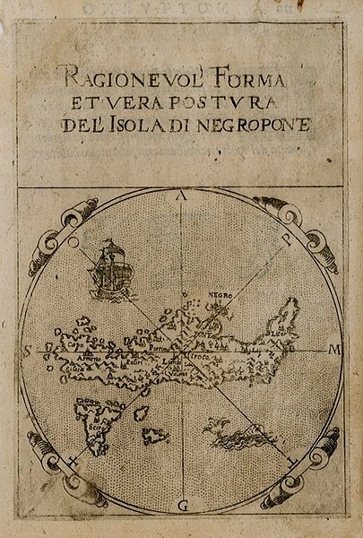
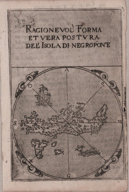
Ragionevole Forma et Vera Postura del' Isola di Negroponte
Ragionevole Forma et Vera Postura del' Isola di Negroponte | Stampe | FERRETTI Francesco
Metodi di Pagamento
- PayPal
- Carta di Credito
- Bonifico Bancario
- Pubblica amministrazione
- Carta del Docente
Dettagli
- Anno di pubblicazione
- 1579
- Luogo di stampa
- Ancona
- Formato
- 86 X 132
- Incisori
- FERRETTI Francesco
- Descrizione
- G. Tolias, Mapping Greece, 0734; Zacharakis, A Catalogue of Printed Maps of Greece 1477-1800, 1516.
Descrizione
Elegante piccola carta geografica dell'isola tratta dai ' Dialoghi Notturni del Capitano Francesco Ferretti Cavaglier di S. Stefano, edito ad Ancona da Giovan Battista Ciotti, nel 1604. Si tratta della seconda edizione del celebre “isolario” di Francesco Ferretti (per la prima volta edito nel 1579), che contiene 28 mappe di isole europee incise in rame, e racchiuse dentro una cornice ornamentale di forma rotonda, che conferisce alle carte un’inusuale e particolarissima forma alla mappa. Questo raro trattato che fornisce nozioni scientifiche e militari, oltre che geografiche e matematiche. La parte geografica costituisce il corpus principale dell’opera, con le 28 mappe raffiguranti le principali isole del Mediterraneo rappresentate con l’inusuale forma circolare, finemente intagliate da Michelangelo Marelli. ' Le carte derivano da quelle intagliate da Girolamo Porro per ' L’isole Piu Famose Del Mondo Descritte Da Thomaso Porcacchi Da Castiglione, edito per la prima volta nel 1572. Ogni carta è racchiusa entro una cornice ornamentale, e mostra le linee dei venti. Il titolo, racchiuso nella parte superiore, è molto grande ed è espresso con la ' formula Ragionevol’ Forma et vera postura del’ Isola di, seguito dal nome dell’isola. Le mappe sono di piccole dimensioni ma molto accurate. ' L’opera del Ferretti venne ristampata nel 1608 con il titolo di ' Arte Militare. Acquaforte e bulino, rifilata la rame o con piccoli margini, in ottimo stato di conservazione. Bibliografia Mortimer 184; Olschki 4539; Cockle 548; Shirley T.FRR-1a. - Nordenskiold Collection I, p.156 no.73; Dufour/La Gumina, p. 85; Ganado 1985 S. 231; Stylianou 81, Navari 33; Zacharakis/Scutari 1499/1003-1518/1022; King, ' Miniature Antique Maps, pp. 62/3. Nice miniature map of the island, taken from ' Dialoghi Notturni del Capitano Francesco Ferretti Cavaglier di S. Stefano ' published in Ancona in 1604. It's the second edition of the rare “Isolario” by Ferretti, that provides scientific knowledge and military, as well as geography and mathematics. The geographical part is the main body of the work, with 28 maps depicting the main islands in the Mediterranean represented with the unusual circular shape, finely carved by Michelangelo Marelli. The maps derive from those engraved by Girolamo Porro for the ' L’isole Piu Famose Del Mondo Descritte Da Thomaso Porcacchi Da Castiglione, published for the first time in 1572. Each map is enclosed within an ornamental frame, and shows the lines of the winds. The title, enclosed at the top, is very large and is expressed by the formula ' Ragionevol’ Forma et vera postura del’ Isola di, followed by the name of the island; the maps are small but very accurate. The work of Ferretti was reprinted in 1608 with the title ' Arte Militare. Literature Mortimer 184; Olschki 4539; Cockle 548; Shirley T.FRR-1a. - Nordenskiold Collection I, p.156 no.73; Dufour/La Gumina, p. 85; Ganado 1985 S. 231; Stylianou 81, Navari 33; Zacharakis/Scutari 1499/1003-1518/1022; King, ' Miniature Antique Maps, pp. 62/3. Cfr. G. Tolias, Mapping Greece, 0734; Zacharakis, A Catalogue of Printed Maps of Greece 1477-1800, 1516.
