Regni Mexicani seu Novae Hispaniae Ludovicianae N. Angliae, Carolinae, Virginiae, et Pensylvaniae…
Regni Mexicani seu Novae Hispaniae Ludovicianae N. Angliae, Carolinae, Virginiae, et Pensylvaniae… | Stampe | HOMANN Johann Baptist


Regni Mexicani seu Novae Hispaniae Ludovicianae N. Angliae, Carolinae, Virginiae, et Pensylvaniae…
Regni Mexicani seu Novae Hispaniae Ludovicianae N. Angliae, Carolinae, Virginiae, et Pensylvaniae… | Stampe | HOMANN Johann Baptist
Metodi di Pagamento
- PayPal
- Carta di Credito
- Bonifico Bancario
- Pubblica amministrazione
- Carta del Docente
Dettagli
- Anno di pubblicazione
- 1716
- Luogo di stampa
- Norimberga
- Formato
- 590 X 490
- Incisori
- HOMANN Johann Baptist
Descrizione
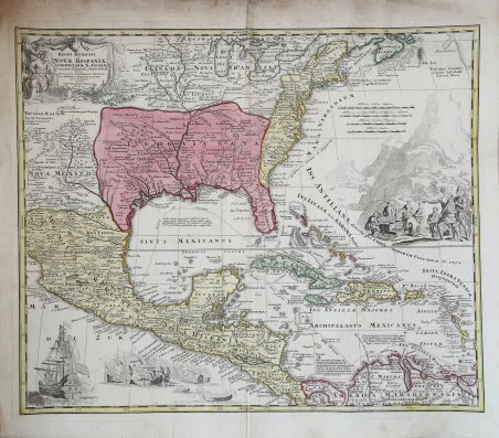
Mappa decorativa basata sulla mappa storica di De L'Isle del Messico e della Florida, pubblicata per la prima volta nel 1703.La mappa introduce le informazioni dei viaggi di La Salle, Bienville, d'Iberville e altri esploratori francesi in America. È stata la prima mappa a rappresentare con precisione la foce del Mississippi e la regione dei Grandi Laghi. Per la prima volta vengono mostrati accuratamente anche gli insediamenti inglesi sulla costa orientale. Vengono mostrate le tracce dei galeoni spagnoli e le rotte per L'Avana. La carta fu realizzata da Homann per il suo Grosser Atlas. ' Johann Baptist Homann è stato un geografo e cartografo tedesco; nel 1702 fondò la sua casa editrice. Homann acquisì fama come uno dei principali cartografi tedeschi, e nel 1715 fu nominato geografo imperiale dall'imperatore Carlo VI. Nello stesso anno fu anche nominato membro dell'Accademia Prussiana delle Scienze a Berlino. Nel 1716 Homann pubblicò il suo capolavoro Grosser Atlas ueber die ganze Welt. Numerose mappe furono redatte in collaborazione con l'incisore Christoph Weigel. Homann morì a Norimberga nel 1724. Gli successe suo figlio Johann Christoph (1703-1730). L'azienda continuò dopo la sua morte come azienda degli eredi Homann, gestita da Johann Michael Franz e Johann Georg Ebersberger. Dopo successivi cambiamenti nella gestione, l'azienda si sciolse nel 1852. Decorative full color example of this decorative map, which is based upon De L'Isle's landmark map of Mexico and Florida, first issued in 1703.The map introduces the information from La Salle, Bienville, d'Iberville and other French explorers in America. It was the first map to accurately portray the mouth of the Mississippi and the Great Lakes region. Also accurately shown for the first time are the English settlements on the east coast. The reports of Iberville are present in the villages in the Lower Mississippi Valley and Texas, where the Spanish were active building missions and presidios. Several Dutch and German cartographers copied De L'Isle's work, but added the rich embellishments present in this map. The tracks of the Spanish Galleons and routes to Havana are shown. The map was made by Homann for his Grosser Atlas. Johann Baptist Homann was a German geographer and cartographer; in 1702 he founded his own publishing house. Homann acquired renown as a leading German cartographer, and in 1715 was appointed Imperial Geographer by Emperor Charles VI. In the same year he was also named a member of the Prussian Academy of Sciences in Berlin. In 1716 Homann published his masterpiece Grosser Atlas ueber die ganze Welt; numerous maps were drawn up in cooperation with the engraver Christoph Weigel the Elder. Homann died in Nuremberg in 1724 and was succeeded by his son Johann Christoph (1703-1730). The company carried on upon his death as Homann heirs company, managed by Johann Michael Franz and Johann Georg Ebersberger. After subsequent changes in management the company folded in 1852. Cfr.
