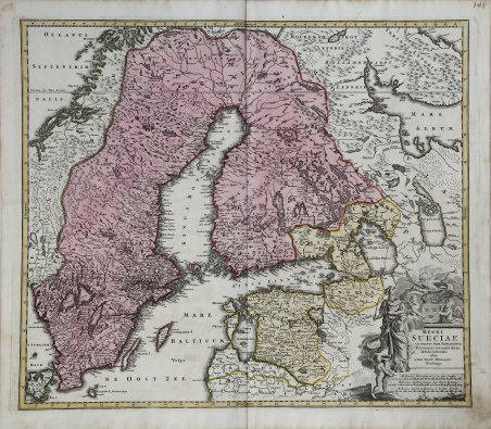
Regni Sueciae in Omnes suas Subjacentes Provincias Accurate Divisi Tabula Generalis
Regni Sueciae in Omnes suas Subjacentes Provincias Accurate Divisi Tabula Generalis | Stampe | HOMANN Johann Baptist


Regni Sueciae in Omnes suas Subjacentes Provincias Accurate Divisi Tabula Generalis
Regni Sueciae in Omnes suas Subjacentes Provincias Accurate Divisi Tabula Generalis | Stampe | HOMANN Johann Baptist
Metodi di Pagamento
- PayPal
- Carta di Credito
- Bonifico Bancario
- Pubblica amministrazione
- Carta del Docente
Dettagli
- Anno di pubblicazione
- 1716
- Luogo di stampa
- Norimberga
- Formato
- 5890 X 500
- Incisori
- HOMANN Johann Baptist
Descrizione
Bella e accurata carta geografica che mostra la Svezia e le regioni baltiche all'epoca sotto il suo dominio: Finlandia, Estonia e Lettonia. Molto dettagliata la toponomastica che segnala città, villaggi, laghi e isole. Sulla destra, il grande cartiglio figurativo, con lo stemma svedese. La carta fu realizzata da Homann per il suo Grosser Atlas. Johann Baptist Homann è stato un geografo e cartografo tedesco; nel 1702 fondò la sua casa editrice. Homann acquisì fama come uno dei principali cartografi tedeschi, e nel 1715 fu nominato geografo imperiale dall'imperatore Carlo VI. Nello stesso anno fu anche nominato membro dell'Accademia Prussiana delle Scienze a Berlino. Nel 1716 Homann pubblicò il suo capolavoro Grosser Atlas ueber die ganze Welt. Numerose mappe furono redatte in collaborazione con l'incisore Christoph Weigel. Homann morì a Norimberga nel 1724. Gli successe suo figlio Johann Christoph (1703-1730). L'azienda continuò dopo la sua morte come azienda degli eredi Homann, gestita da Johann Michael Franz e Johann Georg Ebersberger. Dopo successivi cambiamenti nella gestione, l'azienda si sciolse nel 1852. ' Incisione in rame, coloritura ccoeva, in ottime condizioni. A detailed map that illustrates Sweden and the Baltic states that were at the time under her control - Finland, Latvia, and Estonia. Scores of towns and villages, rivers and lakes and islands are located and named. The large decorative title cartouche features a coat of arms, angel, putti and figures. The map was made by Homann for his Grosser Atlas. Johann Baptist Homann was a German geographer and cartographer; in 1702 he founded his own publishing house. Homann acquired renown as a leading German cartographer, and in 1715 was appointed Imperial Geographer by Emperor Charles VI. In the same year he was also named a member of the Prussian Academy of Sciences in Berlin. In 1716 Homann published his masterpiece Grosser Atlas ueber die ganze Welt; numerous maps were drawn up in cooperation with the engraver Christoph Weigel the Elder. Homann died in Nuremberg in 1724 and was succeeded by his son Johann Christoph (1703-1730). The company carried on upon his death as Homann heirs company, managed by Johann Michael Franz and Johann Georg Ebersberger. After subsequent changes in management the company folded in 1852. ' Etching with fine original colour, good condition. Cfr.
