Dettagli
Anno di pubblicazione
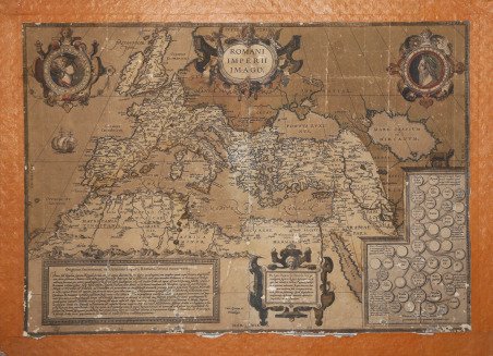
1579
Incisori
ORTELIUS Abraham
Descrizione
Splendida carta storico-geografica dell'Impero Romano, per la prima volta edita nel 1579, ed inserita nel Parergon di Ortelius, il suo celebre atlante storico. La mappa è riccamente decorata: nei due medaglioni in alto sono raffigurati Romolo e Remo; in basso a destra, entro cartiglio, è l'albero genealogico degli imperatori romani, mentre nel pannello di sinistra è una notazione storica sull'Impero. La citazione in alto, sulla destra, è da Vitruvio. Come sottolinea Koeman ". il ' Parergon ' deve essere considerato come lavoro personale di Ortelius. Per quest'opera, infatti, diversamente dal ' Theatrum, ' non copiò le mappe di altri cartografi, ma ne disegnò lui stesso di nuove ed originali…prese luoghi, regioni e territori delle civiltà classiche illustrandone e spiegandone la storia, una materia molto vicina al suo cuore… Le mappe e le lastre del ' Parergon ' devono essere valutate come le più importanti incisioni che rappresentano il diffuso interesse per la geografia classica nel XVI secolo". Incisione in rame con magnifica coloritura coeva. Esemplare montato su antico supporto di collezione, con alcune abrasioni, in discreto stato di conservazione. Bibliografia Van den Broecke, ' Ortelius ' atlas maps, 188. Beautiful map of the Roman Empire centered on the Mediterranean and covering most of Europe, Northern Africa, and the Near and Middle East, published in the Parergon, the historical atlas by by Ortelius. The map is richly decorated with several strapwork cartouches, two containing portraits. The medallion portraits are of Romulus and Remus -the genealogical 'tree' describes the lineage of the Roman emperors while the strap work bordered panels explain the history of the Empire. With a quote in large lettering of four lines by Vitrivius at the top right. Map taken from the ' Parergon; the first historical atlas ever published. It was initially conceived by Ortelius as an appendix to his ' Theatrum Orbis Terrarum but given the considerable success of these historical maps it later became an independent work and remained the main source of all similar works throughout the seventeenth century. ' Koeman wrote: "This atlas of ancient geography must be regarded as a personal work of Ortelius. For this work he did not, as in the ' Theatrum, copy other people's maps but drew the originals himself. He took many places and regions from the lands of classical civilization to illustrate and clarify their history, a subject very close to his heart. The maps and plates of the ' Parergon ' have to be evaluated as the most outstanding engravings depicting the wide-spread interest in classical geography in the 16th century." The ' Theatrum Orbis Terrarum, which is considered the first true modern "Atlas". The work was published in 7 languages and 36 editions, for which - in 1570 - Ortelius obtained the privilege, a kind of copyright that prevented other cartographers from publishing his works. The ' Theatrum ' represented the most advanced work of cartographic description. Ortelius collected in it the geographical and cartographic knowledge of his time, proposing in 147 spectacular engraved plates the most faithful image of the world then known and, in some extraordinary "historical maps", regions and routes taken from literature, mythology, tradition. Copper engraving with contemporary coloring. Mounted example on antique collection mount, with some abrasions, in fair condition. Bibliografia Van den Broecke, ' Ortelius ' atlas maps, 188. Cfr.


 Scopri come utilizzare
 Scopri come utilizzare