Sexta Europa Tabula
Sexta Europa Tabula | Stampe | GERMANUS Donnus Nicolaus
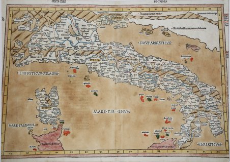
Sexta Europa Tabula
Sexta Europa Tabula | Stampe | GERMANUS Donnus Nicolaus
Metodi di Pagamento
- PayPal
- Carta di Credito
- Bonifico Bancario
- Pubblica amministrazione
- Carta del Docente
Dettagli
- Anno di pubblicazione
- 1482
- Luogo di stampa
- Ulm
- Formato
- 550 X 365
- Incisori
- GERMANUS Donnus Nicolaus
- Descrizione
- R. Borri "L'Italia nelle antiche carteâ¦" (2011), scheda 6; Almagià 6b, Perini p. 20.
Descrizione
Xilografia, 1482 circa. ' Carta a proiezione trapezoidale, dimensioni 550/520x365. Magnifica prova, impressa su carta vergata coeva, in splendida coloritura coeva, minimi restauri alla piega centrale, perfettamente eseguiti, lievemente rifilata al lato sinistro come illustra la foto, per il resto in ottimo stato di conservazione. Rarissima carta a proiezione trapezoidale, tratta dall’edizione del 1486 della Geographia di Ulm.Donnus Nicolaus Germanus era un cartografo di origine tedesca attivo a Firenze nella seconda metà del XV secolo. Sconosciute sono le sue origini, ma il nome Donnus, diminutivo di Dominus, lascia intendere che si tratti di un monaco benedettino probabilmente originario di Reichenbach. Pioniere della cartografia, si dedicò allo studio della traduzione latina della Geographia di Tolomeo curata da Jacopo Angelo. Nel 1466 il Germanus (Nicolaus Laurentii), che lavorava a Firenze come cosmografo presentò in visione a Borso d’Este, duca di Ferrara, il manoscritto di una Geographia, come visto a base dell’edizione di Bologna del 1477. Nel 1468 Nicolaus produsse la sua terza edizione della Geographia, questa volta spostando la Groenlandia a nord della Scandinavia e l’Islanda a Nord Ovest, alla stessa latitudine. A partire dalle mappe di questa terza versione di Nicolaus, furono realizzate le edizioni a stampa della Geographia di Ulm del 1482 e 1486. Si tratta della prime edizioni stampate al di fuori dell’Italia. Il lavoro contiene 32 carte, delle quali cinque non di derivazione tolemaica, tutte realizzate, a differenza delle versioni italiane, in silografia. Le incisioni su legno sono di Johannes Schnitzer di Arnheim. L’opera è considerata come la più elaborata ed importante edizione della Geographia, proprio perché per la prima volta erano aggiunte alcune carte geografiche di fattura moderna, che servivano da paragone con quelle tolemaiche. La successiva ristampa del 1486, fu edita dal Reger, che acquisì le matrici nel 1484 da Holle. Le matrici in legno furono ristampate senza variazioni sostanziali; unico cambiamento è il testo al verso delle carte (dove è tralasciata la decorazione) ed il titolo di ognuna, aggiunto nella parte superiore della mappa. L’edizione del Reger per la prima volta introduce il Registrum alphabeticum e il De locis et mirabili bus mundi, che diverranno molto popolari tanto da essere inseriti nelle successive edizioni del Tolomeo di Roma del 1490 e 1507/8. Magnifico esemplare di questa importante carta. Woodcut, 1482. Magnificent proof, printed on contemporary laid paper, in beautiful contemporary colouring, minimal restoration at center fold perfectly executed, otherwise in excellent condition. The map is cut at the left side, as illustrated. Very rare map on trapezoid projections, from the edition of 1486 of the Geographia of Ulm. Donnus Nicolaus Germanus was a cartographer of German origin active in Florence in the second half of the fifteenth century. Its origins are unknown, but the name Donnus, short for Dominus, suggests that it is probably a Benedictine native of Reichenbach. A pioneer in cartography, he devoted himself to the study of the Latin translation of Ptolemy's Geographia curated by Jacopo Angelo. In 1466 Germanus (Nicolaus Laurentii), who worked in Florence as cosmographer, appeared in a vision to Duke of Ferrara Borso d'Este, the manuscript of a Geographia. In 1468 Nicolaus produced his third edition of the Geographia, this time moving to the north of Scandinavia, Greenland and Iceland in the North West, at the same latitude. Starting from the maps of this third version of Nicolaus, were made the printed editions of the Geographia of Ulm in 1482 and 1486. This is the first editions printed outside Italy. The work contains 32 maps, of which five are not derived from the Ptolemaic, all made, unlike the Italian versions, in woodcut. The woodcuts are by Johannes Schnitzer of Arnheim. The work is considered as the most elaborate and important edition of the Geographia, because for the first time were added some maps of recent construction, which served as a comparison with the Ptolemaic. The next reprint of 1486, was published by Reger, who acquired the matrices in 1484 by Holle. The plates were reprinted without material changes; the only change is the text on the reverse of the map (where the decoration is omitted) and the title of each, added to the top of the map. The edition of Reger for the first time introduces the Registrum alphabeticum and De locis et mirabili bus mundi, which will become popular enough to be included in subsequent editions of Ptolemy to Rome in 1490 and 1507/8.A magnific example. Cfr. R. Borri "L'Italia nelle antiche carte…" (2011), scheda 6; Almagià 6b, Perini p. 20.
