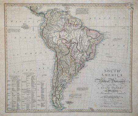
South America with Political Divisions.
South America with Political Divisions. | Stampe | FADEN William

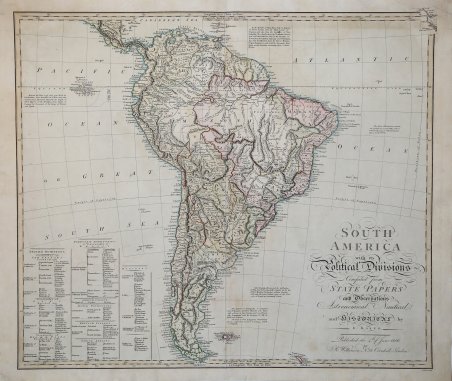
South America with Political Divisions.
South America with Political Divisions. | Stampe | FADEN William
Metodi di Pagamento
- PayPal
- Carta di Credito
- Bonifico Bancario
- Pubblica amministrazione
- Carta del Docente
Dettagli
- Anno di pubblicazione
- 1806
- Luogo di stampa
- Londra
- Formato
- 600 X 517
- Incisori
- FADEN William
Descrizione
South America with its Political Divisions compiled from State Papers and observations Astronomical, Nautical and Historical by E. Baker. Mappa del Sud America di E. Baker, incisa da Bourne, tratta dal A New General Atlas, Londra: William Faden, 1808 circa [mappe datate 1778-1808]. Il ben noto Atlante di William Faden contiene 55 mappe o carte incise, colorate a mano, colorate a mano nei contorni o con tocchi di colorazione a mano, da Faden, Laurie & Whittle, L.S. de La Rochette, Henry Roberts, Baker e altri. Il contributo di Faden "to the development of cartography was considerable, commissioning new surveys and publishing the work of mapmakers throughout Europe" (Tooley). William Faden (1749-1836) fu il più importante cartografo ed editore londinese della fine del XVIII e dell'inizio del XIX secolo. La stella di Faden sorse durante la Rivoluzione Americana, quando produsse mappe e atlanti popolari incentrati sulle colonie americane e sulle battaglie che infuriavano al loro interno. Nel 1783, proprio alla fine della guerra, Faden ereditò il patrimonio del padre, permettendogli di controllare pienamente la sua attività e di espanderla; nello stesso anno ottenne il titolo di "Geographer in Ordinary to his Majesty." Incisione in rame, con bella colorazione originale, buone condizioni. South America with its Political Divisions compiled from State Papers and observations Astronomical, Nautical and Historical by E. Baker. ' Map of South America by E. Baker, engraved by ' Bourne, from A New General Atlas, London: William Faden, ca. 1808 [maps dated 1778-1808]- The well-known Faden Atlas contains 55 engraved maps or charts, hand-colored, hand-colored in outline or with touches of hand-coloring, by Faden, Laurie & Whittle, L.S. de La Rochette, Henry Roberts, Baker and others. Faden's "contribution to the development of cartography was considerable, commissioning new surveys and publishing the work of mapmakers throughout Europe" (Tooley). William Faden (1749-1836) was the most prominent London mapmaker and publisher of the late-eighteenth and early-nineteenth centuries. Faden's star rose during the American Revolution, when he produced popular maps and atlases focused on the American colonies and the battles that raged within them. In 1783, just as the war ended, Faden inherited his father's estate, allowing him to fully control his business and expand it; in the same year he gained the title "Geographer in Ordinary to his Majesty." Copperplate with fine original colouring, good condition. Cfr.
