Tabula Asiae V
Tabula Asiae V | Stampe | MAGINI Giovanni Antonio

Tabula Asiae V
Tabula Asiae V | Stampe | MAGINI Giovanni Antonio
Metodi di Pagamento
- PayPal
- Carta di Credito
- Bonifico Bancario
- Pubblica amministrazione
- Carta del Docente
Dettagli
- Anno di pubblicazione
- 1596
- Luogo di stampa
- Venezia
- Formato
- 180 X 135
- Incisori
- MAGINI Giovanni Antonio
- Lingue
- Italiano
Descrizione
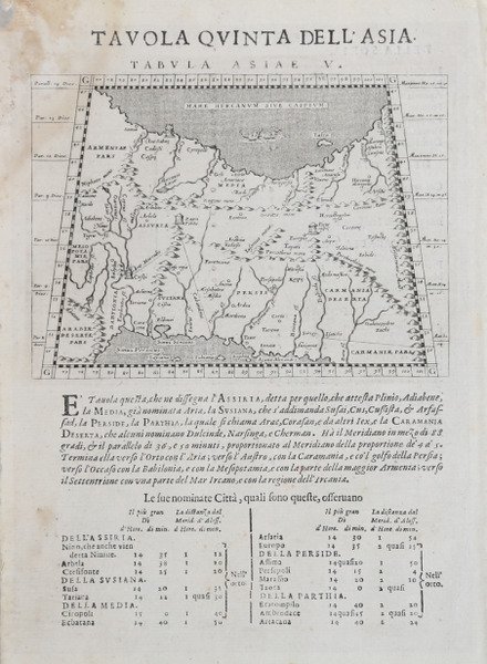
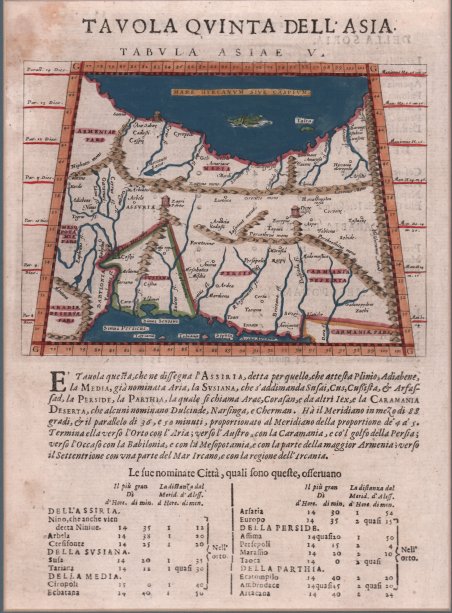
Mappa tolemaica della regione tra il Golfo Persico e il Mar Caspio, che mostra Babilonia e la Mesopotamia, oltre a diversi siti religiosi antichi. La base del Mar Caspio, chiamato anche Mar Ircano, si trova nella parte superiore della mappa. In alto a sinistra si trova l'Armenia e in basso a sinistra il deserto arabo. Sono indicate le principali catene montuose, i fiumi e le città. Carta geografica tratta dalla ' Geografia cioè descrittione universale della Terra ' di Claudio Tolomeo curata dal Magini, per la prima volta stampata a Venezia nel 1596, presso gli Eredi di Simon Galignani de Karera. La raccolta maginiana contiene 64 incisioni in rame finemente intagliate da Girolamo Porro e fu poco dopo copiata da Petrus Keschedt, un editore di Colonia (le mappe delle due edizioni sono pressoché indistinguibili).Una successiva ristampa del lavoro di Magini, con la traduzione di Leonardo Cernoti dal testo latino, venne stampata a Padova dai fratelli Galignani nel 1621. ' Con l’ultima, postuma, edizione maginiana della ' Geografia ' “the long series of editions of Ptolemy’s Geography, revised and extended as text books of modern geography, seems to have come to an end” (Stevens, 1972, p. 22). Incisione in rame, finemente colorata a mano, in ottimo stato di conservazione. Ptolemaic map of the region between the Persian Gulf and the Caspian Sea showing Babylon and Mesopotamia as well as several ancient religious sites. The base of the Caspian Sea, also named the Hyrcanian Sea, is at the top of the map. Armenia is in the upper left, and the Arabian Desert is named in the lower left. Major mountain ranges, rivers, and cities are shown. Map taken from the ' Geografia cioè descrittione universale della Terra ' ' of Claudio Tolomeo by Giovanni Antonio Magini, first printed in Venice in 1596, at the Heirs of Simon Galignani de Karera.The Maginian collection contains 64 copper engravings finely carved by Girolamo Porro and was soon copied by Petrus Keschedt, a publisher from Cologne (the maps of the two editions are almost indistinguishable). ' A subsequent reprint of Magini's work, with the translation by Leonardo Cernoti from the Latin text, was printed in Padua by the Galignani brothers in 1621. With this edition of the ' Geografia ' “the long series of editions of Ptolemy’s Geography, revised and extended as text books of modern geography, seems to have come to an end” (Stevens, 1972, p. 22). Etching with fine later hand colour, in excellent condition. Cfr.
