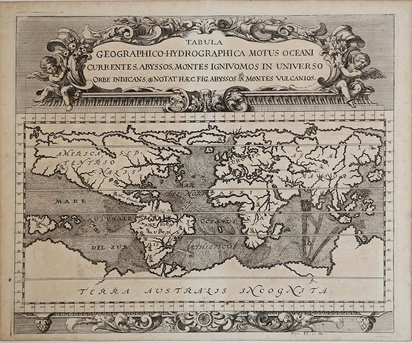
Tabula Geographico-Hydrographica Motus Oceani Currentes, Abyssos, Montes Ignivomos in Universo Orbe…
Tabula Geographico-Hydrographica Motus Oceani Currentes, Abyssos, Montes Ignivomos in Universo Orbe… | Stampe | ZAHN Johann

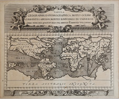
Tabula Geographico-Hydrographica Motus Oceani Currentes, Abyssos, Montes Ignivomos in Universo Orbe…
Tabula Geographico-Hydrographica Motus Oceani Currentes, Abyssos, Montes Ignivomos in Universo Orbe… | Stampe | ZAHN Johann
Metodi di Pagamento
- PayPal
- Carta di Credito
- Bonifico Bancario
- Pubblica amministrazione
- Carta del Docente
Dettagli
- Anno di pubblicazione
- 1696
- Luogo di stampa
- Norimberga
- Formato
- 420 X 350
- Incisori
- ZAHN Johann
- Descrizione
- R. W. Shirley, "The Mapping of the world", 583.
Descrizione
Carta nautica del mondo tratta dalla ' Specula physico-mathematico-historica notabilium ac mirabilium sciendorum, in qua mundi mirabilis oeconomia . nunc autem ad lucem protractus, ac ad varias perfacili methodo acquirendas scientias in epitomen collectus thesaurus curiosis omnibus cosmosophis inspectandus proponitur. / authore Joanne Zahndello Zahn, una cosmografia riccamente illustrata. Zahn era un monaco, studioso e scienziato, si dedicò a studi sulla camera oscura. La sua opera è sulla scia di Athanasius Kircher - studioso gesuita, uno dei primi scrittori sui fenomeni fisici della terra - che, nel suo Mundus Subterraneus (1665) teorizzava che tutti gli oceani della Terra erano connessi tra loro tramite dei tunnel sotterranei che univano oceani e mari. Tra il Mar Mediterraneo, il Mar Nero, il Mar Caspio e il Golfo Persico, Kircher ha teorizzato enormi gallerie e un complesso interscambio di flussi d'acqua. Questi tunnel sono particolarmente noti tra il Mar Nero e il Mar Caspio e tra il Mediterraneo e il Golfo Persico. L'Antartide è rappresentata lungo la parte meridionale della mappa. A nord è raffigurato un grande passaggio aperto a nord-ovest che corre lungo tutta la mappa. Mostra la Nuova Guinea e una suggestione dell'Australia collegata alla terraferma Australsis Incognita. L'Africa è mostrata con una precisione notevolmente maggiore rispetto a molte mappe disegnate centinaia di anni dopo - in particolare per quanto riguarda il Niger e i sistemi fluviali del Nilo. Il Nord America e il Sud America sono entrambi maldestramente raffigurati, il che indica una conoscenza relativamente sommaria del continente. La Corea viene mostrata come un'isola e il Giappone appare come un'unica isola. Incisione in rame, in ottimo stato di conservazione. A world chart from the Specula physico-mathematico-historica notabilium ac mirabilium sciendorum, in qua mundi mirabilis oeconomia . nunc autem ad lucem protractus, ac ad varias perfacili methodo acquirendas scientias in epitomen collectus thesaurus curiosis omnibus cosmosophis inspectandus proponitur. / authore Joanne Zahn, a finely illustrated cosmography, designed to show the ocean currents, vortexes and volcanos. Johann Zahn (1631-1707), a German monk, also published a … read morebook on optics, 'Oculus Artificialis Teledioptricus Sive Telescopium' (1685), with extensive descriptions of both the camera obscura and the magic lantern, which he used for anatomical lectures.[«] SHIRLEY: World 583, "engravings of a high standard". The Mundi Mirabilis oeconomia was influenced by Kircher’s Mundus Subterraneus (1665). The Jesuit scholar, Athanasius Kircher, was one of the first compilers of semi-scientific knowledge about the physical features of the world. This map expounds on Kircher's theories by noting the abysses and the currents they create as well as the locations of the world's known volcanoes. Between the Mediterranean Sea, the Black Sea, the Caspian Sea, and the Persian Gulf, Kircher theorized massive tunnels and a complex interchange of water flows. These tunnels are noted most particularly between the Black and Caspian Sea and between the Mediterranean and the Persian Gulf. Antarctica is shown along the southern part of the map. In the North a great open northwest passage is depicted running all the way across the map. Shows New Guinea and a suggestion of Australia attached to the 'Australsis Incognita' mainland. Africa is shown with considerably greater accuracy than many maps drawn hundreds of years later – particularly with regard to Niger and Nile River Systems. North America and South America are both wildly malformed, indicating a relatively sketchy knowledge of the continent. Korea is shown as an Island and Japan appears as only a single island. Copperplate, very good condition. Cfr. R. W. Shirley, "The Mapping of the world", 583.
