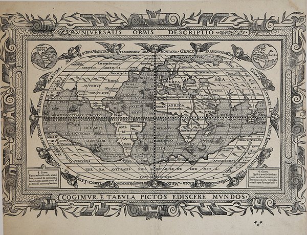
Universalis Orbis Descriptio
Universalis Orbis Descriptio | Stampe | MIRITI [Joannes Myritius] Giovanni

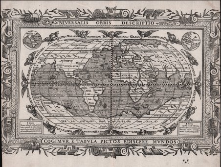
Universalis Orbis Descriptio
Universalis Orbis Descriptio | Stampe | MIRITI [Joannes Myritius] Giovanni
Metodi di Pagamento
- PayPal
- Carta di Credito
- Bonifico Bancario
- Pubblica amministrazione
- Carta del Docente
Dettagli
- Anno di pubblicazione
- 1590
- Luogo di stampa
- Ingolstadt
- Formato
- 400 X 270
- Incisori
- MIRITI [Joannes Myritius] Giovanni
- Descrizione
- Shirley, The Mapping of The World, #175; Portraits of The World, #7, pp. 10-11.
Descrizione
Rara carta del mondo pubblicata nel trattato geografico e astronomico di Giovannni Miriti [Joannes Myritius], Opusculum Geographicum Rarum, stampata a Ingolstadt da Wolfgang Eder. Il mappamondo, in proiezione ovale, è impreziosito da sedici teste di vento cherubiche e da un'imponente bordura decorativa con volute, motivi geometrici e ornamenti botanici raffiguranti piante di mirto. Sebbene sia stata pubblicata nel 1590, dal punto di vista stilistico richiama le carte del mondo della metà del XVI secolo. Infatti, una delle caratteristiche più interessanti della carta è la rappresentazione che Miriti fornisce dell'Asia e dell'America, unite come un'unica massa terrestre, che ricorda i primi lavori di Giacomo Gastaldi. Anche la Groenlandia è rappresentata come parte della massa terrestre americana, un tratto che si ritrova anche nei primi lavori di Gastaldi e in quelli da lui influenzati. Gran parte del Sud-est asiatico e dell'Asia orientale non sono rappresentati su questa carta, compresi il Giappone, la Corea, le Filippine e lo Stretto di Malacca, anche se il Sud-est asiatico continentale è mostrato e un'isola appare tra esso e la California. Agli angoli inferiori della mappa, due pannelli rettangolari contengono citazioni di Cicerone. In alto, gli angoli della mappa contengono inserti circolari del globo, con Europa, Africa e Asia su uno e le Americhe sull'altro. Lo stile incisorio e l'abilità con cui è stata realizzata questa mappa sono evidenti, con contrasti audaci e artistici e raffinati abbellimenti decorativi, tra cui velieri e creature marine. Una sirena è visibile vicino a Terra Australis, mentre una grande bestia marina dal naso a spada nuota al largo della costa meridionale dell'Africa. Montagne e fiumi definiscono le masse terrestri. Le teste dei venti che circondano la proiezione sono tutte denominate, dai venti, in un testo che le circonda. “Joannes Myritius, noto anche come Giovanni Miriti, studioso maltese, ottenne fama internazionale nel 1590 con la pubblicazione della sua opera scientifica Opusculum geographicum raru. Il libro fu stampato due volte, una in formato piccolo e una in folio su carta grande. Il libro è illustrato da numerose xilografie che raffigurano sfere, tavole astronomiche e calcoli utilizzati per stabilire latitudini e longitudini, alcune delle quali con volvelle mobili. Il libro contiene anche due mappe; una è intitolata Peloponneso e mostra la costa più meridionale della Grecia e la punta occidentale di Creta. L'altra carta, un mappamondo pieghevole intitolato Universalis orbis descriptio, ha un bordo decorativo in testa, mentre ai piedi la scritta Cogimur e tabula pictos ediscere mundos indica allo spettatore che può così conoscere i mondi, cioè il vecchio e il nuovo. Miriti ha posto il nord - Tramontana - in cima alla sua mappa, disegnata in proiezione ovale, una tecnica introdotta da Francesco Rosselli e Benedetto Bordone all'inizio del XVI secolo. Il mondo è circondato da sedici teste di cherubini che soffiano il vento, mentre agli angoli superiori della mappa sono disegnate due piccole mappe dei continenti: Mundus novus sive America a sinistra ed Europa, Africa, Asia a destra. Nei pannelli angolari inferiori sono incise citazioni di Cicerone. La carta geografica incisa su legno misura 192 x 322 mm. La grande cornice decorativa che la circonda è impreziosita da rami di mirto. È stato detto che questi sono associati al nome della famiglia Miriti, che sembra derivare la sua origine da questa pianta, membro della famiglia delle mirtacee. Infatti, la cornice del ritratto di Miriti e il suo stemma, riprodotti rispettivamente alle pagine 134 e 135 dell’Opusculum geographicum raru mostrano la stessa foglia di mirto. Giovanni Miriti sembra essere stato uno degli ultimi geografi a tentare di conciliare le nuove scoperte con le teorie precedenti. Nella descrizione dei territori, i continenti dell'Africa e del Sud America sono disegnati abbastanza fedelmente. Tuttavia. Rare map of the world published in Giovannni Miriti's [Joannes Myritius] geographical and astronomical treatise, Opusculum Geographicum Rarum, printed in Ingolstadt by Wolfgang Eder. The world map, in oval projection, is embellished with sixteen cherubic wind heads and an impressive decorative border with scrolls, geometric motifs, and botanical ornaments depicting myrtle plants. Although it was published in 1590, stylistically it is reminiscent of the world maps of the mid-16th century. In fact, one of the most interesting features of the map is the representation Miriti provides of Asia and America, joined as a single land mass, reminiscent of the early work of Giacomo Gastaldi. Greenland is also depicted as part of the American land mass, a trait also found in Gastaldi's early work and those influenced by him. Much of Southeast Asia and East Asia are not represented on this map, including Japan, Korea, the Philippines and the Straits of Malacca, although mainland Southeast Asia is shown and an island appears between it and California. At the lower corners of the map, two rectangular panels contain quotations from Cicero. At the top, the corners of the map contain circular insets of the globe, with Europe, Africa, and Asia on one and the Americas on the other. The engraving style and skill with which this map was made are evident, with bold, artistic contrasts and fine decorative embellishments, including sailing ships and sea creatures. A mermaid is visible near Terra Australis, while a large sword-nosed sea beast swims off the southern coast of Africa. Mountains and rivers define the land masses. The heads of the winds surrounding the projection are all named, by the winds, in text surrounding them. "Joannes Myritius, also known as Giovanni Miriti, a Maltese scholar, achieved international fame in 1590 with the publication of his scientific work Opusculum Geographicum Rarum. The book was printed twice, once in small format and once in folio on large paper. The book is illustrated with numerous woodcuts depicting spheres, astronomical plates, and calculations used to establish latitudes and longitudes, some of them with moving volvelles. The book also contains two maps; one is titled Peloponneso and shows the southernmost coast of Greece and the western tip of Crete. The other map, a folding globe titled Universalis orbis descriptio, has a decorative border at the head, while at the foot the inscription Cogimur and tabula pictos ediscere mundos indicates to the viewer that he can thus know the worlds, that is, the old and the new. Miriti has placed north - Tramontana - at the top of his map, drawn in oval projection, a technique introduced by Francesco Rosselli and Benedetto Bordone in the early 16th century. The world is surrounded by sixteen heads of wind-blowing cherubs, while two small maps of the continents are drawn at the top corners of the map: Mundus novus sive America on the left and Europe, Africa, Asia on the right. In the lower corner panels are engraved quotations from Cicero. The wood-engraved map measures 192 x 322 mm. The large decorative frame surrounding it is embellished with myrtle branches. It has been said that these are associated with the family name Miriti, which seems to derive its origin from this plant, a member of the myrtle family. In fact, the frame of Miriti's portrait and his coat of arms, reproduced on pages 134 and 135, respectively, of Opusculum Geographicum Rarum, show the same myrtle leaf. Giovanni Miriti seems to have been one of the last geographers to attempt to reconcile new discoveries with earlier theories. In his description of the territories, the continents of Africa and South America are drawn quite faithfully. However, Miriti rejected the idea of separating Asia from North America or North America from Greenland. In his eyes, everything was part of “India extra Gangem” (India after the Gange). The first Gastaldian-style maps of the world, as early as 1560, showed. Cfr.
