Vue de Tunis d'Alger & de Gigeri avec quel ques particularitez curieuses touchant les …
Vue de Tunis d'Alger & de Gigeri avec quel ques particularitez curieuses touchant les … | Stampe | CHATELAIN Henri Abraham
Vue de Tunis d'Alger & de Gigeri avec quel ques particularitez curieuses touchant les …
Vue de Tunis d'Alger & de Gigeri avec quel ques particularitez curieuses touchant les … | Stampe | CHATELAIN Henri Abraham
Metodi di Pagamento
- PayPal
- Carta di Credito
- Bonifico Bancario
- Pubblica amministrazione
- Carta del Docente
Dettagli
- Anno di pubblicazione
- 1708
- Luogo di stampa
- Amsterdam
- Formato
- 440 X 380
- Incisori
- CHATELAIN Henri Abraham
- Soggetto
- - Africa -
Descrizione
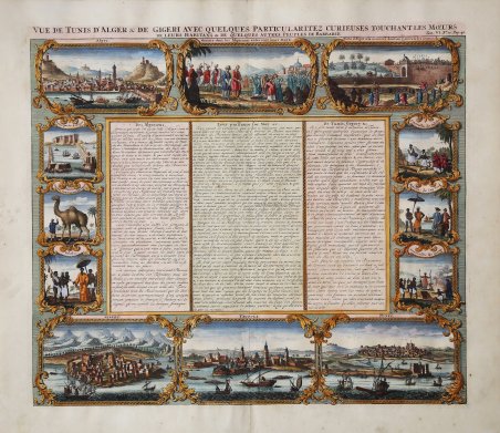
Interessante e ricca serie di vedute che illustrano le città e gli abitanti della Costa di Barberia. Nella parte superiore del foglio si trovano tre vedute di Algeri: navi che si scontrano nella baia, una scena funebre e l'esecuzione di criminali mediante lancio dal muro di cinta su un gancio gigante. Lungo la parte inferiore si trovano tre eccellenti vedute delle baie e delle città di Tripoli e Tunisi. Accanto al testo centrale in francese, altre sei vignette sono dedicate agli abitanti e ai loro costumi. Tavola inserita nell'Atlas Historique, pubblicato ad Amsterdam tra il 1705 e il 1720. L'atlante, in 7 volumi, è innovativo per la sua epoca perché combina le mappe geografiche con incisioni e informazioni di carattere storico, etnografico ed araldico. Henri Abraham Chatelain (1684 - 1743) era un pastore ugonotto di origini parigine. È meglio conosciuto come cartografo olandese e più specificamente per il suo contributo cartografico nell’Atlas Historique ' in sette volumi, pubblicato ad Amsterdam tra il 1705 e il 1720. Innovativo per il suo tempo, l'Atlas Historique ' combinava incisioni e opere d'arte con studi di geografia, storia, etnologia, araldica e cosmografia. Alcuni studiosi suggeriscono che l'Atlas Historique ' non fu compilato esclusivamente da Henri Chatelain, come si crede comunemente, ma piuttosto fu un'impresa familiare che coinvolse Henri, suo padre Zacharie e suo fratello, sempre Zacharie. Acquaforte, finemente colorata a mano, in ottimo stato di conservazione. Very interesting and ornate series of views illustrating the cities and people of the Barbary Coast. At the top of the sheet are three views of Algiers; ships battling in the bay, a funeral scene and the execution of criminals by hurling them off of the battlement wall onto a giant hook. Along the bottom are three excellent views of the bays and towns of Gigery, Tripoli and Tunis. Flanking the central French text, six more vignettes focus on the inhabitants and their customs. Plate taken from Atlas Historique, published in Amsterdam between 1705 and 1720. Henri Abraham Chatelain (1684 - 1743) was a Huguenot pastor of Parisian origins. He is best known as a Dutch cartographer and more specifically for his cartographic contribution in the seminal seven volume ' Atlas Historique, published in Amsterdam between 1705 and 1720. Innovative for its time, the ' Atlas Historique ' combined fine engraving and artwork with scholarly studies of geography, history, ethnology, heraldry, and cosmography. Some scholarship suggests that the ' Atlas Historique ' was not exclusively compiled by Henri Chatelain, as is commonly believed, but rather was a family enterprise involving Henri, his father Zacharie and his brother, also Zacharie. Copper engraving with fine later hand colour, in excellent condition. Cfr.
