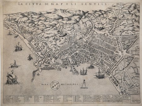
In alto al centro, sotto il margine superiore, e inciso il titolo: LA CITTA DE NAPOLI GENTILE. Lungo il margine inferiore troviamo una legenda numerica di 77 rimandi a luoghi e monumenti notabili distribuita su tredici colonne. Segue l’imprint Claudij Duchetti formis Romae 1585. Al centro della carta, nel mare, una schematica rosa dei venti; il nord-nord-est e a destra. Sempre nel mare, evidenziata da un compasso, la scala grafica Canne 100 pari a mm 29. Esemplare nel primo stato di due, stampato da Claudio Duchetti nel 1585. “La pianta di Napoli di Claudio Duchetti rappresenta una derivazione approssimativa del modello che lo zio Antonio Lafreri fece incidere da Etienne Duperac nel 1566. L’incisione viene attribuita da Destombes ad Ambrogio Brambilla. Si tratta, tuttavia, di una esecuzione poco fedele all’originale, più approssimativa e con un allungamento di circa 5 millimetri rispetto alla scala metrica adottata (circa1: 9.000). La correzione della ripetizione del rimando 41 nella legenda e l’inserimento del nuovo arsenale inducono a pensare che la mappa del Duchetti sia piuttosto una copia della tavola di Mario Cartaro (1579). Del resto, i due si conoscevano bene, e si scontrarono in occasione della divisione ereditaria della tipografia Lafreri, per la quale Cartaro fu nominato perito. Rispetto alla pianta del Cartaro, sono aggiunti due nuovi rimandi nella legenda, per l’arsenale e la chiesa di Santa Maria di Piedigrotta. La lastra fu ereditata da Giacomo Gherardi ed è inserita nel catalogo redatto per conto della vedova Quintilia Lucidi, del 17-19 ottobre 1598 (n. 348 descritta come Napoli in uno foglio reale). Infine, venne acquisita nel 1602, da Giovanni Orlandi che la ristampo inalterata con la sola aggiunta del proprio imprint. Nel 1614 Hendrick van Schoel acquistò la calcografia di Orlandi. Alla morte dell’editore fiammingo le lastre vennero poi cedute a Francesco de Paoli, come documentato dall’inventario della vendita del 2 novembre 1633. Possibile quindi l’esistenza di un’ulteriore stesura della lastra, della quale tuttavia non abbiamo avuto riscontro” (cfr. Cartografia e topografia italiana del XVI secolo, p. 2256). La pianta di Napoli, incisa a Roma nel 1566 da Étienne Dupérac presso la bottega di Antonio Lafreri, è il primo vero monumento topografico della città di Napoli e si inserisce a pieno titolo, sia per le qualità tecniche, sia per quelle artistiche, nel più ampio scenario dell’iconografia urbana europea del Cinquecento. Per due secoli, è stata considerata la migliore rappresentazione di Napoli: realizzata con grande rigore geometrico, è la prima ad essere basata su un preciso rilievo topografico – non noto, probabilmente effettuato con il patrocinio della Corona Spagnola o del viceré Pedro de Toledo. Questa veduta a volo d’uccello restituisce in maniera puntuale il volto della città cinquecentesca sotto il regno di Filippo II, costituendo in tal modo un prezioso documento dello sviluppo urbano seguito alle iniziative promosse da don Pedro de Toledo, autore dell’ultimo progetto pubblico di ristrutturazione urbanistica a Napoli. L’immagine è realizzata con grande precisione e dovizia di particolari, attraverso la rappresentazione tridimensionale delle architetture cittadine, tanto da diventare un prototipo per gli incisori ed editori per tutto il Seicento. Una grande attenzione è data alla rappresentazione del circuito murario che costituisce ' la maggiore realizzazione/opera urbanistica a Napoli fino all’Ottocento. Molto ricco l’apparato decorativo, con un cartiglio a cornice barocca e numerose imbarcazioni in mare e nel porto. Tra le peculiarità della carta vanno rimarcate la scala elevata (1:5110 ca) e la sua continuità in ogni parte del disegno, ad eccezione delle prospettive paesaggistiche verso i Campi Flegrei. La pianta, quindi, proviene da un poderoso rilevamento topografico, forse appoggiato anche ad una triangolazione geometrica, tecni. In the upper center, below the top margin, is engraved the title: LA CITTA DE NAPOLI GENTILE. Along the lower margin we find a numerical legend of 77 references to notable places and monuments spread over thirteen columns. This is followed by the imprint Claudij Duchetti formis Romae 1585. In the center of the map, in the sea, a schematic wind rose; the North-Northeast, to the right. Example in the first state of two, printed by Claudio Duchetti in 1585, and before the Giovanni Orlandi address. Claudio Duchetti's plan of Naples represents an approximate derivation of the model that his uncle Antonio Lafreri had engraved by Etienne Duperac in 1566. The engraving is attributed by Destombes to Ambrogio Brambilla. It is, however, an execution not very faithful to the original, more approximate and with an elongation of about 5 millimeters with respect to the adopted metrical scale (about1: 9,000). The correction of the repetition of the 41 references in the legend and the inclusion of the new arsenal lead one to think that Duchetti’s map is rather a copy of Mario Cartaro's plate (1579). After all, the two knew each other well, and they clashed on the occasion of the hereditary division of the Lafreri printing house, for which Cartaro was appointed surveyor. Compared to Cartaro's plan, two new references are added in the legend, for the arsenal and the church of Santa Maria di Piedigrotta. (cfr. Cartografia e topografia italiana del XVI secolo, p. 2256). The plan of Naples, engraved in Rome in 1566 by Étienne Dupérac at the workshop of Antonio Lafreri, is the first true topographical monument of the city of Naples and is fully inserted, both for its technical and artistic qualities, in the broader scenario of sixteenth-century European urban iconography. For two centuries, it was considered the best representation of Naples: made with great geometric rigor, it is the first to be based on a precise topographical survey-unknown, probably carried out under the patronage of the Spanish Crown or viceroy Pedro de Toledo. This bird's-eye view accurately restores the face of the sixteenth-century city under the reign of Philip II, thus constituting a valuable document of the urban development that followed the initiatives promoted by Don Pedro de Toledo, author of the last public urban restructuring project in Naples. The image is made with great precision and detail, through the three-dimensional representation of the city's architecture, so much so that it became a prototype for engravers and editors throughout the seventeenth century. Great attention is given to the representation of the wall circuit, which constitutes the major urbanistic achievement/work in Naples until the 19th century. The decorative apparatus is very rich, with a baroque framed cartouche and numerous boats at sea and in the harbor. Among the peculiarities of the map should be noted the high scale (1:5110 ca) and its continuity in every part of the drawing, with the exception of the landscape perspectives towards the Phlegraean Fields. The plan, therefore, comes from a mighty topographical survey, perhaps also leaning on geometric triangulation, a technique already known at the time. As mentioned, however, Duchetti was also inspired by the plan of Mario Cartaro (1579), which is not limited, however, to copying the Lafreri’s model, as the work is updated with some urbanistic changes. In fact, the warehouses of the new arsenal, work on which had begun in 1577, are represented; moreover, the new buildings dedicated to the Spanish troops that rose at the foot of San Martino are here more complete than in the original model. Cartaro’s map it0s the first to show in the title the adjective "gentile," with which the fifteenth-century chronicler Loise De Rosa qualified Naples. The qualification gentile is the most current in the Aragonese era among those reserved for the city: great, noble and beautiful. Etching and engraving, impressed on contemporary lai. Cfr.


 Découvrez comment utiliser
 Découvrez comment utiliser