Dettagli
Anno di pubblicazione
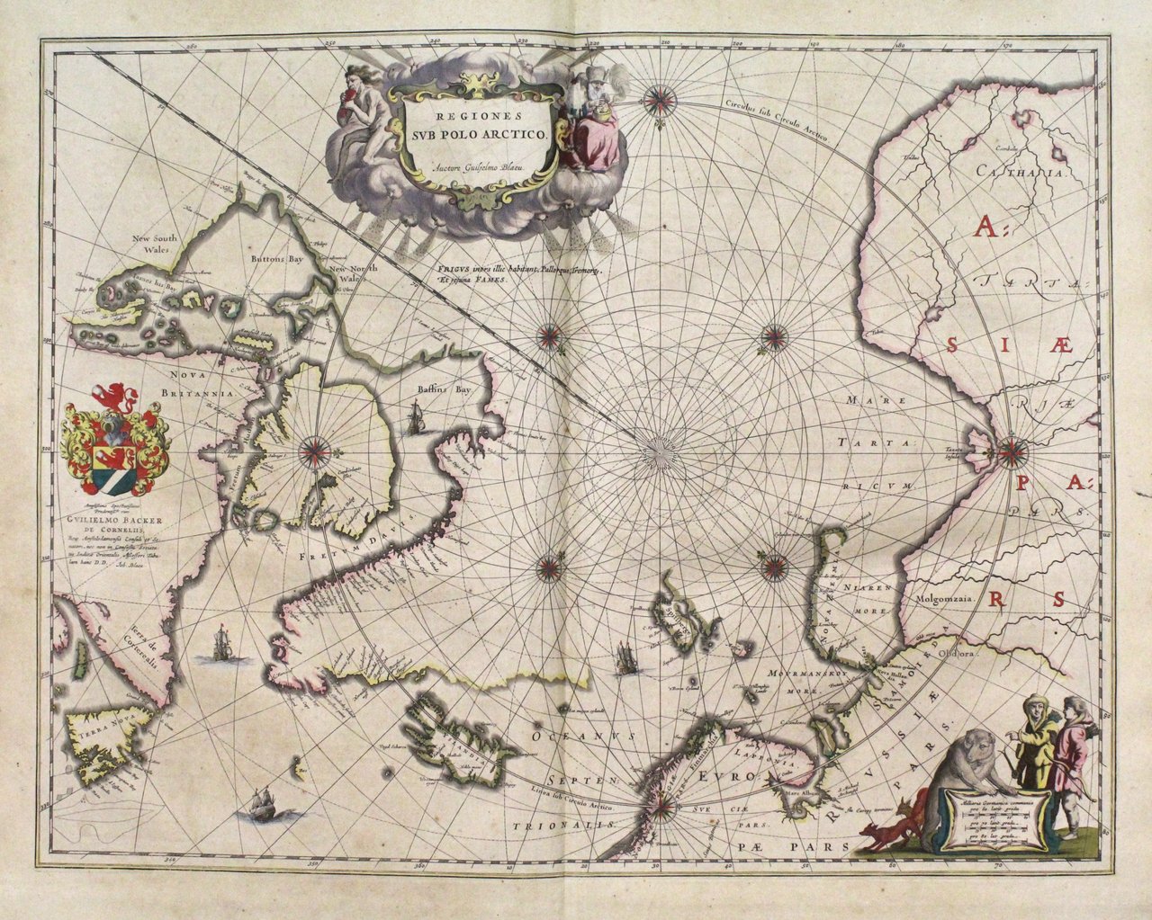
1640
Luogo di stampa
Amsterdam
Descrizione
Incisione in rame, mm 410x530, testo latino al verso. Elegante e piacevole carta, arricchita da cartigli, navi e stemmi. A nice example of Blaeu's important map of the North Polar Regions, enriched with cartouches and decorative coat of arms. It had been the most updated map of its time: Spitsberg and Nova Zemla are shown, but I not in a complete fashion, but as known after the Danish expeditions of 1605-1607. To the left we see the discoveries of captain Thomas James of Bristol along the southern and western shores of the Hudson Bay during his expedition of 1631/32 (with, among others, "James his Bay"). All discoveries of the late 16th and early 17th Centuries are plainly in evidence.<BR>Ottimo esemplare perfettamente conservato anche se lievemente ingiallito. W. Blaeu, astronomo allievo di Tycho Brahe, fondò un'officina per la costruzione di globi nel 1599; quasi immediatamente iniziò a pubblicare anche carte geografiche, giungendo nel 1630 alla creazione del primo atlante "Atlantis Appendix" e cinque anni dopo, della prima edizione in due tomi del "Atlas Novus". Dopo la sua morte nel 1638, a cura del figlio Johan si giunse nel 1662 alla pubblicazione del celebre "Atlas Maior" in 11 volumi. Nel 1672 un incendio distrusse l'officina e segnò la fine dell'attività. Van der Krogt 2, 0020:2.2; Burden, 252.1<BR>Copper engraving, mm 410x530, latin text on verso. Good condition even if slightly discolored. A nice example of Blaeu's important map of the North Polar Regions, enriched with cartouches and decorative coat of arms. It had been the most updated map of its time: Spitsberg and Nova Zemla are shown, but I not in a complete fashion, but as known after the Danish expeditions of 1605-1607. To the left we see the discoveries of captain Thomas James of Bristol along the southern and western shores of the Hudson Bay during his expedition of 1631/32 (with, among others, "James his Bay"). All discoveries of the late 16th and early 17th Centuries are plainly in evidence.<BR>W. Blaeu, born in Alkmaar in 1571, studied astronomy by Tycho Brahe and founded a business in 1599 as a globe and instrument maker. He immediately expanded the business publishing maps and in 1630 the first atlas "Atlantis appendix" and five years later the "Atlas novus". After his death in 1638, his son Joan reached publication of the major work of the family, the "Atlas maior" in 11 volumes. In 1672 a great fire destroyed the Blaeu's printing house. Van der Krogt 2, 0020:2.2; Burden, 252.1<BR><BR><BR>

 Scopri come utilizzare
 Scopri come utilizzare