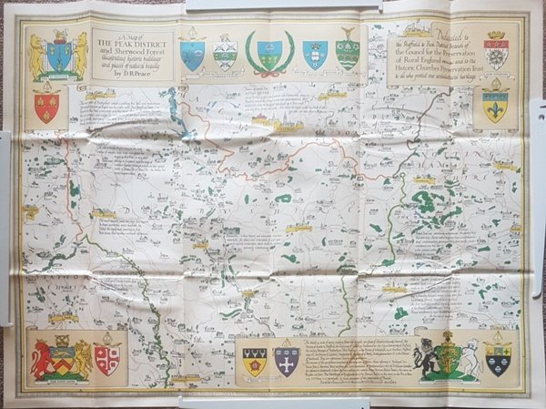
A Historic Buildings Map of the Peak District and Sherwood Forest
Libros antiguos y modernos
Peace, D. B.
Architectural Maps,
1953
A Historic Buildings Map of the Peak District and Sherwood Forest
Libros antiguos y modernos
Peace, D. B.
Architectural Maps,
1953
9,25 €
(Hyde,
Reino Unido)
Formas de Pago
- PayPal
- Tarjeta de crédito
- Transferencia Bancaria
- Pubblica amministrazione
- Carta del Docente
Detalles
- Año de publicación
- 1953
- Lugar de impresión
- Stafford
- Autor
- Peace, D. B.
- Editores
- Architectural Maps
- Formato
- 29.25 x 21.75 Inches
- Materia
- Map. Peak District, Heraldry, Sherwood Forest
- Descripción
- Soft Cover
- Sobrecubierta
- False
- Conservación
- Muy bueno
- Idiomas
- Inlgés
- Encuadernación
- Tapa blanda
- Copia autógrafa
- False
- Primera edición
- False
Descripción
Folded map. No marks or inscriptions. No creasing to covers. A very clean very tight copy, bright unmarked, not torn and no bumping to corners. 1pp. Some 450 historic buildings, including 228 churches, are illustrated on the map from sketches and with Heraldic Emblems. On the reverse side is a comprehensive guide arranged alphabetically to the places of interest in towns and villages from Abney to Youlgreave. The map covers parts of Yorkshire West Riding, Cheshire, Staffordshire, Derbyshire and Nottinghamshire. Both map sides are held open to photograph with laid-on metal supports.