A General Map of the World, or Terraqueouis Globe with all the New Discoveries and Marginal Delineations, Containing the Mos
A General Map of the World, or Terraqueouis Globe with all the New Discoveries and Marginal Delineations, Containing the Mos | Grabados | DUNN Samuel
A General Map of the World, or Terraqueouis Globe with all the New Discoveries and Marginal Delineations, Containing the Mos
A General Map of the World, or Terraqueouis Globe with all the New Discoveries and Marginal Delineations, Containing the Mos | Grabados | DUNN Samuel
Formas de Pago
- PayPal
- Tarjeta de crédito
- Transferencia Bancaria
- Pubblica amministrazione
- Carta del Docente
Detalles
- Año de publicación
- 1794
- Lugar de impresión
- Londra
- Formato
- 1245 X 1067
- Grabadores
- DUNN Samuel
Descripción
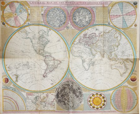
Una mappa assolutamente straordinaria e monumentale del mondo, rappresentato con la classica proiezione a doppio emisfero. Firmata da Samuel Dunn e datata 1794, la carta è basata sulla precedente ricerca cartografica di J. B. D'Anville. Pubblicata da Laurie e Whittle nell'edizione del Thomas Kitchin's General Atlas, describing the Whole Universe: being a complete collection of the most approved maps extant; corrected with the greatest care, and augmented from the last edition of D'Anville and Robert with many improvements by other eminent geographers, engraved on Sixty-Two plates, comprising Thirty Seven maps, stampato a Londra nel 1797.La mappa primaria è circondata in tutti i lati, da calcoli e descrizioni scientifiche dettagliate, nonché le tabelle degli stelle dell'emisfero settentrionale e meridionale, una mappa della Luna, un diagramma raffigurante latitudine e longitudine, una mappa del Sistema Solare e una proiezione mercatoriona del mondo. Tutto il testo è in inglese.Questa mappa segue poco dopo le esplorazioni del capitano Cook nell'Artico e nel Pacifico nordoccidentale, per cui è conosciuto il profilo generale del continente.L'Asia è particolarmente ben mappata, riflettendo le più recenti informazioni disponibili in Europa - soprattutto per quanto riguarda le esplorazioni di Vitus Bering e Tschirikow nell'Articolo siberiano. L'Australia appare completamente come “New Holland o Terra Australis”. Nomi numerosi punti lungo la costa con appunti associati alle attività di vari esploratori. La terra di Van Diemen o Tasmania è curiosamente attaccata alla terraferma - un errore che molte vecchie mappe avevano corretto molto tempo prima. La Nuova Zelanda orientale è eccezionalmente ben formata. La maggior parte della regione è stata completamente mappata da Cook, anche se molti degli errori cartografici perpetuati da Quiros sono presenti. Poca traccia dell'Antartide o del grande continente meridionale, anche se l'isola di Bouvet appare come "Sandwich Land". Samuel Dunn (1723-1794) fu un insegnante di matematica e navigazione che pubblicò, tra l'altro, mappe e carte nautiche. Sebbene manchino informazioni sulla sua formazione iniziale, all'età di diciannove anni dirigeva una propria scuola e insegnava scrittura, contabilità, navigazione e matematica nel Devonshire. Nel 1751 si trasferì a Londra, dove insegnò in diverse scuole e diede lezioni private. Negli anni Sessanta del Novecento, Dunn era conosciuto come un astronomo rispettato e aveva pubblicato una serie di libri di testo sulla matematica, la navigazione e l'astronomia. Dopo la pubblicazione del Nautical Almanac, Dunn agì come certificatore dei comandanti delle navi secondo il nuovo sistema, per conto del Board of Longitude. Svolse un lavoro simile per la Compagnia delle Indie Orientali e realizzò carte nautiche delle Indie Orientali. Nel 1776 pubblicò A New Variation Atlas e, nel 1777, A New Epitome of Practical Navigation, or, Guide to the Indian Seas. Nel 1780 fu nominato editore del New Directory for the East Indies, che includeva le sue carte nautiche. Progettò anche diversi strumenti per la navigazione. ' Incisione in rame, stampata su quattro gradi fogli di carta coeva uniti, finemente colorata a mano, in ottimo stato di conservazione. An absolutely stunning and monumental double hemisphere wall map of the world by Samuel Dunn dating to 1794. Drawn in London by Thomas Dunn based on earlier cartographic research by J. B. B. D'Anville. Published by Laurie and Whittle as plate nos. 1-2 in the 1797 edition of Thomas Kitchin's General Atlas, describing the Whole Universe: being a complete collection of the most approved maps extant; corrected with the greatest care, and augmented from the last edition of D'Anville and Robert with many improvements by other eminent geographers, engraved on Sixty-Two plates, comprising Thirty Seven maps., Laurie & Whittle, London, 1797. Covers the entire world in a double hemisphere projection. The primary map is surrounded on all sides but detailed scientific calculations and descriptions as well as northern and southern hemisphere star charts, a map of the Moon, a Latitude and Longitude Analemma chart, a map of the Solar System, a Mercator projection of the world, an Analemma projection, a seasonal chart, a universal scale chart, and numerous smaller diagrams depicting planets and mathematical systems. All text is in English.This map follows shortly after the explorations of Captain Cook in the Arctic and Pacific Northwest, so the general outline of the continent is known. Asia is exceptionally well mapped reflecting the most recent information available in Europe - especially regarding the explorations of Vitus Bering and Tschirikow in the Siberian Arctic. Notes Macau, Formosa (Tay-oan), numerous silk route cities, the straits of Sin Capura (Singapore), Beijing (Peking), Edo (Tokyo) and Bombay. Australia appears in full as New Holland or Terra Australis. Names numerous points along the coast with associated notes regarding the activities of various explorers. Van Diemen's Land or Tasmania is curiously attached to the mainland - an error that many earlier maps had long ago corrected. Further east New Zealand is exceptionally well formed. Most of the region has been thoroughly mapped by Cook, though several of the cartographic errors perpetuated by Quiros are present. There is little trace of either Antarctica or the Great Southern continent, though Bouvet's Island does appear as 'Sandwich Land.' Samuel Dunn (1723-1794) was a teacher of mathematics and navigation who published, among other things, maps and charts. Although information about his early education is lacking, by age nineteen he was leading his own school and teaching writing, accounting, navigation, and mathematics in Devon. In 1751, he moved to London, where he taught in several schools and tutored privately. By the 1760s, Dunn was known as a respected astronomer and had published a range of textbooks on math, navigation, and astronomy. After the publication of the ' Nautical Almanac, Dunn acted as a certifier of ships’ masters under the new system, on behalf of the Board of Longitude. He performed similar work for the East India Company, as well as made charts of the East Indies. In 1776 he published ' A New Variation Atlas ' and, in 1777, ' A New Epitome of Practical Navigation, or, Guide to the Indian Seas. By 1780, he was named editor of the ' New Directory for the East Indies, which included his own charts. In 1786, he released a pioneering study, ' Theory and Practice of Longitude at Sea. He also designed several instruments for navigation. Etching, printed on four joined sheets, with fine later hand colour, very good condition. Cfr.
