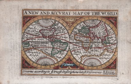
A New and Accurat Map of the World Drawne according to ye truest Descriptions latest Discoveries
A New and Accurat Map of the World Drawne according to ye truest Descriptions latest Discoveries
Formas de Pago
- PayPal
- Tarjeta de crédito
- Transferencia Bancaria
- Pubblica amministrazione
- Carta del Docente
Detalles
- Año de publicación
- 1646
- Lugar de impresión
- Londra
- Formato
- 130 X 85
- Grabadores
- SPEED John
Descripción
Bell'esemplare a colori della rara carta del mondo in miniatura di John Speed. Proiezione a doppio emisfero, tratta dall'Epitome di Speed, venne incisa da Peter Kaerius nel 1646. La mappa è degna di nota perché non mostra la California come un'isola, una delle prime dell'epoca a rifiutare questo mito. Un enorme continente meridionale sconosciuto e un ponte terrestre ipotizzato per collegare il Nord America all'Asia. La mappa indica il Golfo di Carpentaria come Mare Lanthidol. Il nome ebraico di Dio YHWH è scritto tra gli emisferi. Carta tratta da A prospect of the most famous parts of the world, viz. Asia, Africa, Europe, America. With these empires and kingdoms therein contained; viz. Grecia, Roman-empire, Germany, Bohemia, France, Belgia, Spain, Italy, Hungary, Denmark, Poland, Persia, Turkish-empire, kingdom of China, Tartaria, Summer-islands / by John Speed. London stampato da Roger Rea, Londra 1668. John Speed (1551 o '52 - 28 luglio 1629) è stato il più noto cartografo inglese del periodo degli Stuart. Speed si avvicinò tardi alla cartografia, producendo le sue prime mappe nell’ultimo decennio del XV secolo ed entrando seriamente nel commercio quando aveva quasi 60 anni. La fama di John Speed, che dura tuttora, è dovuta a due atlanti, The Theatre of the Empire of Great Britaine (pubblicato per la prima volta nel 1612) e Prospect of the Most Famous Parts of the World (1627). Le tavole dell'atlante passarono di mano in mano nel XVII secolo e il libro raggiunse la sua apoteosi nel 1676, quando fu pubblicato da Thomas Bassett e Richard Chiswell, con l'aggiunta per la prima volta di alcune importanti mappe. Bibliografia Shirley, R. The mapping of the world, 1472-1700, Entry 368. Nice full color example of Speed's rare scarce miniature Double Hemisphere of the World, from Speed's Epitome. Engraved by Peter Kaerius in 1646. The map is noteworthy for its not showing California as an Island, one of the of the period to reject the myth. Massive unknown southern continent and conjectural land bridge connecting North America and Asia. Strapwork decorations and symbols of the elements in the corners. A New and Accurat Map of the World, marking the Gulf of Carpentaria as the ' Mare Lanthidol. The Hebrew name of G-d YHWH is written between the hemispheres. Of possible interest are the displayed features of the Strait of Anian, Terra incognita and Terra Australis. Map taken from A prospect of the most famous parts of the world, viz. Asia, Africa, Europe, America. With these empires and kingdoms therein contained; viz. Grecia, Roman-empire, Germany, Bohemia, France, Belgia, Spain, Italy, Hungary, Denmark, Poland, Persia, Turkish-empire, kingdom of China, Tartaria, Summer-islands / by John Speed. London : Printed for Roger Rea, 1668. John Speed (1551 or '52 - 28 July 1629) was the best known English mapmaker of the Stuart period. Speed came to mapmaking late in life, producing his first maps in the 1590s and entering the trade in earnest when he was almost 60 years old. John Speed's fame, which continues to this day, lies with two atlases, ' The Theatre of the Empire of Great Britaine ' (first published 1612), and the ' Prospect of the Most Famous Parts of the World ' (1627). While ' The Theatre ' . started as solely a county atlas, it grew into an impressive world atlas with the inclusion of the ' Prospect ' in 1627. The plates for the atlas passed through many hands in the 17th century, and the book finally reached its apotheosis in 1676 when it was published by Thomas Bassett and Richard Chiswell, with a number of important maps added for the first time. Bibliografia Shirley, R. The mapping of the world, 1472-1700, Entry 368 Cfr.

