Aevi Veteris Typus Geographicus
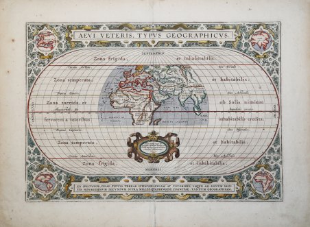
Aevi Veteris Typus Geographicus
Formas de Pago
- PayPal
- Tarjeta de crédito
- Transferencia Bancaria
- Pubblica amministrazione
- Carta del Docente
Detalles
- Año de publicación
- 1590
- Lugar de impresión
- Anversa
- Formato
- 450 X 320
- Grabadores
- ORTELIUS Abraham
- Materia
- Carte Storiche
- Descripción
- Shirley #176; Van den Broecke #186.
Descripción
Splendida carta del Mondo Antico pubblicata nel Parergon, l'atlante di Ortelius dedicato alla geografia antica.La mappa presenta i territori conosciuti fino al 1492, all'interno di una proiezione ovale in cui sono rappresentate le fasce climatiche canonizzate da Tolomeo. Ortelius, inoltre, nella realizzazione del planisfero tiene conto del passo di Strabone (II, 5,6) nel quale sostiene che la terra abitata occupi meno della metà dell'emisfero boreale. Pur con queste premesse, il disegno dell'ecumene è moderno, come mostrano i profili del golfo di Guinea, del Madagascar e della penisola indocinese.Il planisfero è circondato da una ricca cornice decorativa nei cui angoli sono contenute le mappe, di formato circolare, dei quattro continenti. Tratta dal ' Parergon, il primo atlante storico mai pubblicato. Fu inizialmente concepito da Ortelius come appendice del suo ' Theatrum Orbis Terrarum ' ma visto il notevole successo di queste carte storiche divenne in seguito un lavoro indipendente e rimase la fonte principale di tutti i lavori simili per tutto il XVII secolo. Come sottolinea Koeman “il ' Parergon ' deve essere considerato come lavoro personale di Ortelius. Per quest'opera, infatti, diversamente dal ' Theatrum, non copiò le mappe di altri cartografi, ma ne disegnò lui stesso di nuove ed originali…prese luoghi, regioni e territori delle civiltà classiche illustrandone e spiegandone la storia, una materia molto vicina al suo cuore. Le mappe e le lastre del ' Parergon ' devono essere valutate come le più importanti incisioni che rappresentano il diffuso interesse per la geografia classica nel XVI secolo”. Il ' Theatrum Orbis Terrarum ' e che è considerato il primo vero “atlante” moderno. L’opera fu pubblicata in 7 lingue e 36 edizioni, per il quale – nel 1570 - Ortelius ottenne il ' privilegio, ovvero una sorta di diritto d'autore che impediva ad altri cartografi di pubblicare i propri lavori. Il ' Theatrum ' rappresentava il lavoro più avanzato del lavoro della descrizione cartografica. L’Ortelius vi raccolse il sapere geografico e cartografico del suo tempo, proponendo in 147 spettacolari tavole incise l’immagine più fedele del mondo allora conosciuto e, in alcune straordinarie “carte storiche”, regioni e itinerari tratti dalla letteratura, dalla mitologia, dalla tradizione. Incisione su rame, finemente acquarellata, in ottimo stato di conservazione. Esemplare dall'edizione tedesca pubblicata nel 1602. Bibliografia ' Cfr. L. Bagrow, ' A. Ortelli Catalogus Cartographorum; cfr. C. Koeman, ' Atlantes Neerlandici; ' Peter H. Meurer, ' Fontes Cartographici Orteliani, ' n. 13p; M. Van den Broecke, ' Ortelius Atlas Maps, n. 186 II/II; Van der Krogt, ' Koeman’s Atantes Neerlandici: 0800H:31; Shirley map 176, plate 143, pp. 193-194. This interesting map presents the regions of the earth that were known in classic times within a large oval projection showing the relative size of the now-known world. The map extends into Asia as far east as Sumatra and south to Madagascar and the Mountains of the Moon in Africa. The climate zones are shown as Zona frigida, temperata, and torrida, with the Zona frigida noted as being uninhabitable. An ornate border surrounds the map and incorporates four small insets: Europe, Asia, Africa and America representing the "modern" world. Map taken from the ' Parergon, the first historical atlas ever published. It was initially conceived by Ortelius as an appendix to his ' Theatrum Orbis Terrarum, but given the considerable success of these historical maps it later became an independent work and remained the main source of all similar works throughout the seventeenth century. Koeman wrote: "This atlas of ancient geography must be regarded as a personal work of Ortelius. For this work he did not, as in the ' Theatrum, copy other people's maps but drew the originals himself. He took many places and regions from the lands of classical civilization to illustrate and clarify their history, a subject very close to his heart. The maps and plates of the ' Parergon ' have to be evaluated as the most outstanding engravings depicting the wide-spread interest in classical geography in the 16th century." The ' Theatrum Orbis Terrarum, which is considered the first true modern "Atlas". The work was published in 7 languages and 36 editions, for which - in 1570 - Ortelius obtained the privilege, a kind of copyright that prevented other cartographers from publishing his works. The ' Theatrum ' represented the most advanced work of cartographic description. Ortelius collected in it the geographical and cartographic knowledge of his time, proposing in 147 spectacular engraved plates the most faithful image of the world then known and, in some extraordinary "historical maps", regions and routes taken from literature, mythology, tradition. From the 1602 German edition of the Parergon. Copperplate, with fine colouring, good conditions. Bibliografia ' Cfr. L. Bagrow, ' A. Ortelli Catalogus Cartographorum; cfr. C. Koeman, ' Atlantes Neerlandici; ' Peter H. Meurer, ' Fontes Cartographici Orteliani, ' n. 13p; M. Van den Broecke, ' Ortelius Atlas Maps, n. 186 II/II; Van der Krogt, ' Koeman’s Atantes Neerlandici: 0800H:31; Shirley map 176, plate 143, pp. 193-194. Cfr.