America Septentrionalis
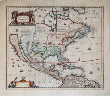
America Septentrionalis
Formas de Pago
- PayPal
- Tarjeta de crédito
- Transferencia Bancaria
- Pubblica amministrazione
- Carta del Docente
Detalles
- Año de publicación
- 1694
- Lugar de impresión
- Amsterdam
- Formato
- 540 X 460
- Grabadores
- Valck & Schenk Tipografia
- Descripción
- P. D. Burden "The mapping of America", 245
Descripción
La prima carta del solo Nord America mai pubblicata in un atlante olandese. Nel 1604, Jodocus Hondius (1563-1612) - probabilmente tramite Cornelis Claesz - acquistò le matrici in rame dell'Atlas sive cosmographicae meditationes de fabrica mundi ' di Gerard Mercator all’asta. Aggiunse circa 40 mappe, comprese nuove mappe dei continenti e importanti mappe regionali delle Americhe, prima di pubblicare una nuova edizione dell’opera, nel 1606, in concorrenza con il ' Theatrum Orbis Terrarum ' di Ortelius. Poiché molte delle mappe erano più aggiornate, la raccolta di Mercator & Hondius sostituì effettivamente il ' Theatrum ' di Ortelius. ' L’atlante del 1606 include tutte le 107 mappe dell’edizione del 1595, oltre a 37 nuove mappe, abilmente incise dallo stesso Hondius. La seconda edizione della raccolta seguì già nel 1607/08, mentre la prima edizione in un’altra lingua, il francese, fu messa sul mercato nel 1609. Apparentemente questa fu considerata come la terza edizione, perché nel 1611 apparve l'Editio Quarta, ' con un totale di 150 mappe. Dopo la morte di Jodocus Hondius (1612) la sua vedova e i suoi figli continuarono la stampa dell’atlante. Jodocus Junior ( o Jodocus II, 1594-1629) produsse diverse ristampe tra il 1613 e il 1619, sempre con le stesse 150 mappe; nel 1619 furono invece aggiunte sei nuove mappe. Dopo il 1620 la pubblicazione venne curata da Hendrick (Henricus) Hondius (1597-1651), il secondo figlio di Jodocus senior. Varie edizioni apparvero, nel 1623, 1628 e 1630. Hendrick fu il primo ad apportare dei veri cambiamenti: nell’edizione del 1628 firmò alcune mappe di Mercatore con il proprio nome. Nel 1630, quando probabilmente stava già collaborando con suo cognato Johannes Janssonius, aggiunse nove nuove carte. La prima edizione della mappa, firmata da Hendrick Hondius è databile al 1636/39; successivamente la lastra, senza alcuna modifica, venne ristampata da Janssonius, Visscher ed Allard. Nel 1694 Petrus Schenk si aggiudica in un'asta pubblica tutte le lastre dell'Atlas Major ' di Janssonius e comincia subito a pubblicare questa mappa con il suo indirizzo: ' Amstelodami, Penes Gerardum Valck et Petrus Schenk. Dopo il 1700, Schenk aggiorna la mappa sulla base della più avanzata geografia di Guillaume de L'Isle. Si tratta del terzo stato della carta di Hondius, con l'imprint di Valck e Schenk. “Henricus Hondius' beautifully engraved map of North America had greater influence than any other to date in perpetuating the theory of California as an island. This was because it was disseminated through the medium of his powerful Dutch publishing house. None of the earlier California as an island maps had reached such a wide audience. The 1630s were a decade of constant development in the houses of Blaeu and Hondius. It is interesting to note that Blaeu never produced a single sheet map of North America; both Willem and Joan relied upon that of the whole continent first produced in 1617, throughout their publishing history. During this decade Joannes Janssonius became an active partner of Hondius, and although this map bears no imprint it is assigned to the latter on the basis that at the same time a map of South America appeared displaying his name. Cartographically this map is a careful composition of many different sources and illustrates well the current state of knowledge. The depiction and nomenclature of the west, along with that of the insular California, derive directly from the Henry Briggs The North Part of AMERICA, 1625. A legend placed strategically over the north-west coastline offers the opportunity to discontinue a coastline least understood. An unnamed lake still feeds a Rio del Norto flowing incorrectly south-west into what should be the headwaters of the Gulf of California. On the east bank of this river is Real de Nueua Mexico, or Santa Fe. The Gulf of Mexico and the Florida peninsula originate from the Hessel Gerritsz chart of c.1631. The east coast, however, is harder to. Valck & Schenk edition of the earliest separate map of the North America to appare in any Dutch Atlas, first published by Hendrick Hondius in 1636/39, then by Janssonius and often included in the composite Visscher and Allard atlases. In 1604, Jodocus Hondius (1563-1612) – probably trought Cornelis Claesz - bought the copperplates of Mercator’s ' Atlas sive cosmographicae meditationes de fabrica mundi ' at the auction of Gerard Jr.’s effects. He added about 40 maps, including new maps of the Continents and important regional maps of the Americas, before publishing a new edition of the Atlas, in 1606, in competition with Ortelius’ ' Theatrum Orbis Terrarum. As many of the maps were more up-to-date, the Mercator-Hondius Atlas effectively superseded Ortelius’ ' Theatrum. ' This atlas from 1606 include all 107 maps from the 1595 edition, as well as 37 new maps, skillfully engraved by Hondius, of various authors. The second edition of the Mercator-Hondius atlas followed as soon as 1607/08. The first edition in another language, French, was put on the market in 1609. Apparently this one was regarded as the third edition, because in 1611 ' Editio Quarta ' appeared with a total of 150 maps. After the death of Jodocus Hondius in 1612 his widow and sons continued the publication of the ' Atlas. ' For instance Jodocus Junior (1594-1629) produced several new editions of the ' Editio Quarta ' between 1613 and 1619, each with the same 150 maps. Finally in 1619 the last edition of this atlas followed, to which six new maps were added. After 1620 the publication of the ' Atlas ' was continued by Henricus Hondius (ca. 1596/97-1651), the second son of Jodocus senior. Various editions appeared, in 1623, 1628 and 1630. Henricus Hondius was the first to make some real changes: in the 1628 edition he provided some Mercator maps with his own name. In 1630, when he was probably already cooperating with his brother-in- law Johannes Janssonius, Henricus added nine new maps. In 1694 Petrus Schenk acquired all of the ' Atlas Major ' maps at public auction, and began issuing the map with his own imprint. This last state is uncommon. Shortly, after 1700 he relaced the map with a new one based upon the more advanced geography of Guillaume de L'Isle. “Henricus Hondius' beautifully engraved map of North America had greater influence than any other to date in perpetuating the theory of California as an island. This was because it was disseminated through the medium of his powerful Dutch publishing house. None of the earlier California as an island maps had reached such a wide audience. The 1630s were a decade of constant development in the houses of Blaeu and Hondius. It is interesting to note that Blaeu never produced a single sheet map of North America; both Willem and Joan relied upon that of the whole continent first produced in 1617, throughout their publishing history. During this decade Joannes Janssonius became an active partner of Hondius, and although this map bears no imprint it is assigned to the latter on the basis that at the same time a map of South America appeared displaying his name. Cartographically this map is a careful composition of many different sources and illustrates well the current state of knowledge. The depiction and nomenclature of the west, along with that of the insular California, derive directly from the Henry Briggs The North Part of AMERICA, 1625. A legend placed strategically over the north-west coastline offers the opportunity to discontinue a coastline least understood. An unnamed lake still feeds a Rio del Norto flowing incorrectly south-west into what should be the headwaters of the Gulf of California. On the east bank of this river is Real de Nueua Mexico, or Santa Fe. The Gulf of Mexico and the Florida peninsula originate from the Hessel Gerritsz chart of c.1631. The east coast, however, is harder to define; the south-east appears to be quite generic in form. It is the area north of here that does not appear t. Cfr.