Detalles
Lugar de impresión
Norimberga
Grabadores
HOMANN Eredi Johannes Baptiste
Descripción
Lowery Collection #383; Wagner #1746.
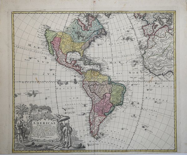
Descripción
Carta geografica raffigurante l'intero continente, tratta dal "Atlas…" edito dagli eredi della tipografia Homann. La mappa riporta diversi dettagli, risultato delle nuove conoscenze acquisite dagli esploratori e colonizzatori. La California è rappresentata come penisola. Molto decorativo il grande cartiglio allegorico con il titolo, arricchito con vulcani, flora e fauna dell'America. Johann Baptist Homann è stato un geografo e cartografo tedesco; nel 1702 fondò la sua casa editrice. Homann acquisì fama come uno dei principali cartografi tedeschi, e nel 1715 fu nominato geografo imperiale dall'imperatore Carlo VI. Nello stesso anno fu anche nominato membro dell'Accademia Prussiana delle Scienze a Berlino. Nel 1716 Homann pubblicò il suo capolavoro Grosser Atlas ueber die ganze Welt. Numerose mappe furono redatte in collaborazione con l'incisore Christoph Weigel. Homann morì a Norimberga nel 1724. Gli successe suo figlio Johann Christoph (1703-1730). L'azienda continuò dopo la sua morte come azienda degli eredi Homann, gestita da Johann Michael Franz e Johann Georg Ebersberger. Dopo successivi cambiamenti nella gestione, l'azienda si sciolse nel 1852. ' Incisione in rame, bella coloritura coeva, ottime condizioni. This attractive map of the Americas is filled with detail throughout. There is no coastline shown above the peninsular California, leaving out the usual conjectures about the Northwest Passage. South America shows very developed river systems, with the La Plata River terminating in a fictional Lacus Xarayes. The extravagant title cartouche includes two erupting volcanoes, Native Americans (one who appears to be holding a shrunken head), birds and a pot of gold or silver. A strong sheet with original color and some toning with a small hole on the centerfold. The margins have some light stains and a chip,a nd there is a soft crease on the left side of the map. Johann Baptist Homann was a German geographer and cartographer; in 1702 he founded his own publishing house. Homann acquired renown as a leading German cartographer, and in 1715 was appointed Imperial Geographer by Emperor Charles VI. In the same year he was also named a member of the Prussian Academy of Sciences in Berlin. In 1716 Homann published his masterpiece Grosser Atlas ueber die ganze Welt; numerous maps were drawn up in cooperation with the engraver Christoph Weigel the Elder. Homann died in Nuremberg in 1724 and was succeeded by his son Johann Christoph (1703-1730). The company carried on upon his death as Homann heirs company, managed by Johann Michael Franz and Johann Georg Ebersberger. After subsequent changes in management the company folded in 1852. Cfr. Lowery Collection #383; Wagner #1746.

 Descubre cómo utilizar
 Descubre cómo utilizar