Detalles
Lugar de impresión
Anversa
Grabadores
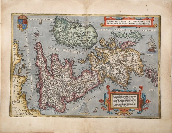
ORTELIUS Abraham
Descripción
Broecke, Ortelius 16, state 3. Shirley (1991), map 82, plate 42.
Descripción
Carta geografica delle Isole Britanniche tratta dall'edizione italiana del Theatrum Orbis Therrarum di Ortelius, 1606.Terzo stato della lastra di questa importante mappa basata sulla carta murale di Mercator del 1564. Il ' Theatrum Orbis Terrarum ' è considerato il primo vero “atlante” moderno. L’opera fu pubblicata in 7 lingue e 36 edizioni, per il quale – nel 1570 - Ortelius ottenne il ' privilegio, ovvero una sorta di diritto d'autore che impediva ad altri cartografi di pubblicare i propri lavori. Il ' Theatrum ' rappresentava il lavoro più avanzato del lavoro della descrizione cartografica. L’Ortelius vi raccolse il sapere geografico e cartografico del suo tempo, proponendo in 147 spettacolari tavole incise l’immagine più fedele del mondo allora conosciuto e, in alcune straordinarie “carte storiche”, regioni e itinerari tratti dalla letteratura, dalla mitologia, dalla tradizione. Ortelius fu anche il primo a citare le fonti, menzionando i nomi dei cartografi nel “catalogus auctorum”. Dal 1598 al 1612 le edizioni postume del ' Theatrum ' furono realizzate dal suo collaboratore Johannes Baptiste Vrients. Incisione in rame, eccellente coloritura coeva, in ottimo stato di conservazione. Attractive full color example of Ortelius' first map of the British Isles, from Ortelius' Theatrum Orbis Terrarum, the first modern atlas of the world.A state 3 of this classic, handsome and decorative map of ancient British Isles with north orientated to the east. Italian text on verso. From the Vrients edition of 1606.Based on Mercator's 1564 map of the British isles and improved by Saxton's 1579 map and the writings of the ancient classical writers. Embellishments include seven ships and three decorative strap work cartouches. Map taken from the ' Theatrum Orbis Terrarum, which is considered the first true modern "Atlas". The work was published in 7 languages and 36 editions, for which - in 1570 - Ortelius obtained the privilege, a kind of copyright that prevented other cartographers from publishing his works. The ' Theatrum ' represented the most advanced work of cartographic description. Ortelius collected in it the geographical and cartographic knowledge of his time, proposing in 147 spectacular engraved plates the most faithful image of the world then known and, in some extraordinary "historical maps", regions and routes taken from literature, mythology, tradition. Ortelius was also the first to cite sources, mentioning the names of cartographers in the "catalogus auctorum". From 1598 to 1612 the posthumous editions of the ' Theatrum ' were made by his collaborator Johannes Baptiste Vrients. Copper engraving, contemporary coloring, in good condition. Cfr. Broecke, Ortelius 16, state 3. Shirley (1991), map 82, plate 42.

 Descubre cómo utilizar
 Descubre cómo utilizar