Aquapendente / Tarvisi
Aquapendente / Tarvisi | Grabados | BRAUN & Franz HOGENBERG Georg
Aquapendente / Tarvisi
Aquapendente / Tarvisi | Grabados | BRAUN & Franz HOGENBERG Georg
Formas de Pago
- PayPal
- Tarjeta de crédito
- Transferencia Bancaria
- Pubblica amministrazione
- Carta del Docente
Detalles
- Año de publicación
- 1598
- Lugar de impresión
- Anversa e Colonia
- Formato
- 495 X 370
- Grabadores
- BRAUN & Franz HOGENBERG Georg
Descripción
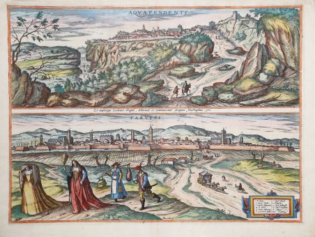
Foglio contenente le vedute prospettiche di Acquapendente e Treviso. L’opera è inserita nel ' Civitates Orbis Terrarum, il primo atlante devoto esclusivamente alle piante e vedute delle principali città del mondo. ' La veduta di Acquapendente di G. Hoefnagel, ripresa sa un soggetto Ludovico Toeput detto il Pozzoserrato. ' La veduta da ovest evidenzia la posizione della città su una terrazza rocciosa a strapiombo. A sinistra della città si trova la cattedrale di San Sepolcro e al centro la chiesa di San Francesco, il cui importante campanile risale al Rinascimento. In cima alla collina, all'estrema destra, si trova il Monastero di Santa Chiara, costruito nel 1333 su un sito precedentemente occupato da una fortezza imperiale. La veduta della città fortificata di Treviso è presa da Sud. Così Georg Braun descrive la città: “Treviso è una nobile città della Marca Trevigiana, molto famosa nella storia dei Goti, poiché il padre del re Totila, che regnò a Verona e a Treviso, si dilettava particolarmente in questa città e vi abitava lui stesso, e suo figlio Totila, che poi divenne re degli Ostrogoti, vi nacque e fu educato. La città di Treviso ha tutte le necessità della vita in abbondanza, poiché è molto ben fornita di grano, vino, altri frutti e bestiame. Nella città sul fiume Sile ci sono molte fontane e magnifici edifici e case”. Il primo volume delle ' Civitates Orbis Terrarum ' fu pubblicato a Colonia nel 1572. Il sesto e ultimo volume apparve nel 1617. Questo grande atlante di città – cartografia urbana - curato da Georg Braun e inciso in gran parte da Franz Hogenberg, conteneva 546 prospettive, vedute a volo d'uccello e vedute cartografiche di città di tutto il mondo. Franz Hogenberg realizzò le tavole dei primi quattro volumi e Simon van den Neuwel (Novellanus, attivo dal 1580) quelle dei volumi V e VI. Georg Braun (1541-1622), un ecclesiastico di Colonia, fu il principale redattore dell'opera e fu molto aiutato nel suo progetto dalla vicinanza e dal continuo interesse di Abraham Ortelius, il cui ' Theatrum Orbis Terrarum ' del 1570 fu, come raccolta sistematica e completa di mappe di stile uniforme, il primo vero atlante. Le ' Civitates, ' in effetti, erano destinate ad accompagnare il ' Theatrum, ' come indicato dalla somiglianza dei titoli e dai riferimenti contemporanei sulla natura complementare delle due opere. Tuttavia, le ' Civitates ' erano progettate per avere un approccio più popolare, senza dubbio perché la novità di una raccolta di piante e vedute di città rappresentava un'impresa commerciale più rischiosa di un atlante mondiale, per il quale c'erano stati diversi precedenti di successo. Franz Hogenberg (1535-1590) era figlio di un incisore di Monaco che si era stabilito a Malines. Incise la maggior parte delle tavole del ' Theatrum ' di Ortelius e la maggior parte di quelle delle ' Civitates, e potrebbe essere anche indicato come il responsabile dell'origine del progetto. Oltre un centinaio di artisti e cartografi diversi, il più importante dei quali fu l'artista di Anversa Georg Hoefnagel (1542-1600), fornirono i disegni per le tavole delle ' Civitates. Hoefnagel non solo contribuì alla maggior parte del materiale originale per le città spagnole e italiane, ma rielaborò e modificò anche quello di altri collaboratori. Dopo la morte di Hoefnagel, il figlio Jakob continuò il lavoro per le ' Civitates. Gli autori della raccolta si proponevano di raffigurare "non icones et typi urbium", cioè non immagini generiche e tipizzate, "sed urbes ipsae admirabili caelaturae artificio, spectantium oculis subiectae appareant": non intendeva alludere o idealizzare, ma rappresentare fedelmente sulla carta, riprodurre esattamente, e in tempo reale, ciò che l'occhio vede, come annunciato nella prefazione al primo volume delle ' Civitates Orbis Terrarum. Incisione in rame, finemente colorata a mano, in ottimo stato di conservazione. Sheet containing perspective views of Acquapendente and Treviso. The work is included in Civitates Orbis Terrarum, the first atlas devoted exclusively to plans and views of the world's major cities. View of Acquapendente by G. Hoefnagel after Ludovico Toeput. ' The view from the west highlights the town's dramatic location on a precipitous rock terrace. On the left of the town lies the cathedral of San Sepolcro and in the centre the church of San Francesco, whose prominent bell tower dates from the Renaissance. On top of the hill on the far right lies the Monastero di Santa Chiara, built in 1333 on a site formerly occupied by an imperial fortress. Acquapendente, which in 1499 became part of the Papal States, lies north of the Lake Bolsena on the road that leads from Siena to Rome via Viterbo. The fortified city of Treviso is seen from the south, in its picturesque setting on the banks of the Sile River with the Alps (11) in the background. The tallest tower in the city is the Torre del Comune (6) on the Piazza dei Signori, which is surrounded by palaces with open arcades. Further left is the cathedral of San Pietro (1). Further left again is the Dominican church of San Nicolò. Commentary by Braun: “Treviso is a noble town in the March of Treviso and very famous in the history of the Goths, since the father of King Totila, who ruled in Verona and Treviso, took particular delight in this town and lived there himself, and his son Totila, who later became king of the Ostrogoths, was born and educated there. The city of Treviso has all the necessities of life in abundance, for it is very well supplied with grain, wine, other fruits and cattle. In the city on the River Sile there are very many drinking fountains and magnificent buildings and houses.” The work is included in the ' Civitates Orbis Terrarum, the first atlas devoted exclusively to plans and views of the world's major cities. Printed in six volumes between 1572 and 1617 it was so successful and widespread that several editions translated into Latin, German and French were printed. The first volume of the ' Civitates Orbis Terrarum ' was published in Cologne in 1572. The sixth and the final volume appeared in 1617. This great city atlas, edited by Georg Braun and largely engraved by Franz Hogenberg, eventually contained 546 prospects, bird-eye views and map views of cities from all over the world. Fransz Hogenberg produced the plates for the first four books, and Simon van den Neuwel (Novellanus, active since 1580) those for volumes V and VI. Georg Braun (1541-1622), a cleric of Cologne, was the principal editor of the work, and was greatly assisted in his project by the close, and continued interest of Abraham Ortelius, whose ' Theatrum Orbis Terrarum ' of 1570 was, as a systematic and comprehensive collection of maps of uniform style, the first true atlas. The ' Civitates, ' indeed, was intended as a companion for the ' Theatrum, ' as indicated by the similarity in the titles and by contemporary references regarding the complementary nature of two works. Nevertheless, the ' Civitates ' was designs to be more popular in approach, no doubt because the novelty of a collection of city plans and views represented a more hazardous commercial undertaking than a world atlas, for which there had been a number of successful precedents. Franz Hogenberg (1535-1590) was the son of a Munich engraves who settled in Malines. He engraved most of the plates for Ortelius's ' Theatrum ' and the majority of those in the ' Civitates, and may have been responsible for originating the project. Over a hundred of different artists and cartographers, the most significant of whom was Antwerp artist Georg Hoefnagel (1542-1600), engraved the cooper-plates of the ' Civitates ' from drawings. He not only contributed most of the original material for the Spanish and Italian towns but also reworked and modified those of other contributors. After Hoefnagel's death his son Jakob continued the work f. Cfr.
