Detalles
Lugar de impresión
Londra
Descripción
Shirley T.SPE-2a-d; Sweet 30 mit Abb.; Tibbetts 76; Al Ankary 44.
Descripción
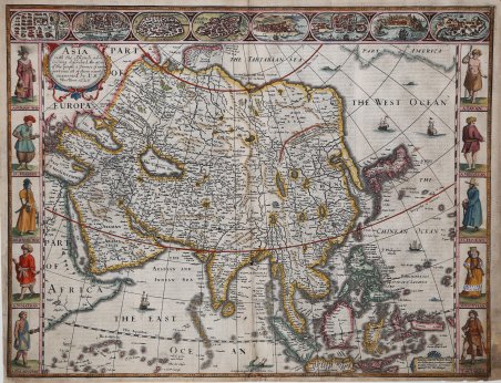
“Questa mappa è la prima carta inglese a stampa del continente asiatico” (Shirley). Secondo stato (di tre), dall’edizione del “Prospect” di Speed, edito da Reas nel 1662.Questa bella carta-a-figures è la prima mappa inglese stampata dell'Asia. Ai lati è arricchita da figure in costume tipico dei popoli asiatici, con una serie di otto vedute di città, che formano un fregio decorativo nella parte superior, tra cui Damasco, Gerusalemme, Aden, Hormus, Goa, Kandy, Banten e Macao. La mappa si basa in gran parte sulla carta di Jodocus Hondius del 1623 con raffigurazioni dettagliate delle Indie Orientali, le Filippine e la forma allungata penisola di Corea. Grandi laghi e fiumi dominano l’intero della Cina e il mitico lago di Ciamay genera cinque grandi fiumi nell'India senza il Gange. La Grande Muraglia cinese è posta troppo a nord. Il Mar Caspio è notevolmente ampliato. La mappa è ulteriormente impreziosita da un cartiglio per il titolo, numerose creature marine e navi a vela e un elefante che appare all'interno della Cina. Splendidamente incisa da Abraham Goos con l'imprint di Roger Rea, pubblicata nel 1662. Il testo inglese al verso offre un'affascinante punto di vista inglese sull'Asia. Lievemente brunita, con qualche sporadica macchia, una più grande a sinistra, piccolo strappi perfettamente restaurati che toccano appena l’inciso, e piccolo strappi in corrispondenza degli angoli e del margine sinistro, nel complesso in buone condizioni. This is the earliest English printed map of the continent of Asia (Shirley). Second state (of 3) from the edition publish by the Reas in 1662 of Speed's "Prospect". This beautiful carte-a-figures map is the first English printed map of Asia. It is flanked by costumed figures of Asian peoples with a series of eight city views forming a decorative frieze across the top including Damascus, Jerusalem, Aden, Hormus, Goa, Kandy, Banten and Macau. The map is based largely on Jodocus Hondius' map of 1623 with detailed depictions of the East Indies, the Philippines and the elongated peninsula form of Korea. Large lakes and rivers dominate the interior of China and the mythical Lake of Ciamay spawns five large rivers in India Without Ganges. The Great Wall of China is placed too far north. The Caspian Sea is greatly enlarged and oriented in an east-west direction. The map is further embellished with a title cartouche, numerous sea creatures and sailing ships and an elephant appears in the interior of China. Beautifully engraved by Abraham Goos with the imprint of Roger Rea, published in 1662. The English text on verso provides a fascinating Anglo-centric view of Asia. Copperplate, light browning and some spotting in places, large brownish spot at left; light shine-through of text. Repairs to few small tears at bottom just affecting engraved area, and to small split at each lower corner and at left margin, generally in good condition. Cfr. Shirley T.SPE-2a-d; Sweet 30 mit Abb.; Tibbetts 76; Al Ankary 44.

 Descubre cómo utilizar
 Descubre cómo utilizar