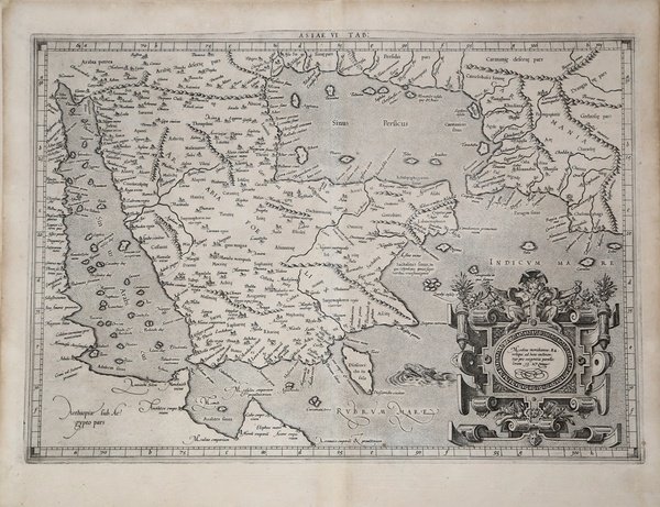
ASIAE VI TAB.
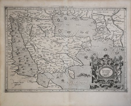
ASIAE VI TAB.
Formas de Pago
- PayPal
- Tarjeta de crédito
- Transferencia Bancaria
- Pubblica amministrazione
- Carta del Docente
Detalles
- Año de publicación
- 1578
- Lugar de impresión
- Colonia
- Formato
- 487 X 342
- Grabadores
- MERCATOR (Kremer) Gerard
- Descripción
- Van der Krogt, P. (Atlantes) 0926:1.2; Tibbetts, G.R. 39; Al Ankary 262. McMinn 15.
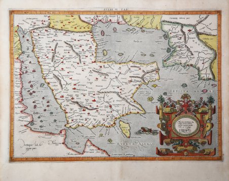
Descripción
Carta tolemaica del Medio Oriente di Gerard Mercator, basata sulle coordinate geografiche di Claudio Tolomeo. La carta di Mercator è considerata una pietra miliare nella mappatura della penisola arabica. In origine, Tolomeo si era basato sui resoconti di viaggiatori e marinai e, sebbene le informazioni fossero di seconda mano e spesso imprecise, rappresentavano il resoconto più avanzato della geografia dell'epoca. Nel caso dell'Arabia, Tolomeo sovrastimò sia l'ampiezza della parte meridionale dell'Arabia sia le dimensioni e la forma del Golfo Persico. L'Arabia Petrea e l'Arabia Deserta sono entrambe collocate a nord e l'Arabia Felix è il termine applicato all'intera penisola, piuttosto che alle sue porzioni meridionali. Mappa tolemaica della penisola arabica, detta Arabia Felix, tratta dal ' Cl. Ptolemaei Alexandrini, Geographiae Libri Octo, ' pubblicata prima a Colonia da Gottfried von Kempen (1578) e poi ristampata dallo stesso editore nel 1584 (Van der Krogt 1, 502) e poi da Isaac Elsevier per il ' Theatrum Geographiae veteris ' di Petrus Bertius (Leyden 1618). Di tutte le edizioni di Tolomeo, quella di Gerard Kremer (Mercatore), pubblicata nel 1578, e forse tecnicamente la più bella. A questo punto la ' Geografia ' di Tolomeo perdeva pero ogni pretesa di “attualità”, laddove lo scopo di Mercatore era quello di produrre un atlante del mondo classico che servisse da complemento al suo atlante moderno (per tale ragione egli aveva tentato di recuperare la forma originale dell’atlante tolemaico, scartandone le moderne accrezioni). L'interpretazione di Mercatore del testo tolemaico, per le 28 carte che illustrano la sua ' Geographia ' è stata, quindi, una delle più veritiere. Egli aveva passato 13 anni a ricercare, disegnare e incidere le carte, rinunciando anche alla pubblicazione delle sue carte “moderne”. Questo esemplare proviene dal ' Theatrum Geographia Veteris ' di Petrus Bertius edita a Leida nel 1618, che combina il Tolomeo di Mercator, le 8 tavole del Moretus per rappresentare la ' Tabula Peutingeriana ' e 14 mappe storiche delle regioni d'Europa derivate dal ' Parergon ' di Ortelius. Acquaforte, finemente colorata a mano, in ottime condizioni. ' Eearly and scarce map of present day Saudi Arabia, Qatar, United Arab Emirates, Yemen, and Oman. ' Mercator's Ptolemaic map of the Middle East, based upon the works of Claudius Ptolemy. Mercator's map was a landmark in the mapping of the Arabian Peninsula, being the last published edition of Ptolemy and without question the most heavily researched and studied of all editions by its maker. Ptolemy had originally drawn on the accounts of travelers and sailors and though the information was secondhand and often inaccurate it represented the most advanced account of the world's geography at that time. In the case of Arabia, Ptolemy overestimated both the width of the southern part of Arabia and the size and shape of the Persian Gulf. Arabia Petrea and Arabia Deserta are both placed in the north and Arabia Felix is the term applied to the whole peninsula, rather than to the southern portions of it. ' Map taken from the ' Cl. Ptolemaei Alexandrini, Geographiae Libri Octo, ' first published in Cologne by Gottfried von Kempen (1578) and then reprinted by the same publisher in 1584 (Van der Krogt 1, 502) and then by Isaac Elsevier for the Petrus Bertius’ ' Theatrum Geographiae veteris ' (Leyden 1618). Mercator's interpretation of the 28 Ptolemaic text was possibly one of the truest undertaken up until that time. He had spent 13 years researching, drawing and engraving the maps at much commercial sacrifice to himself, having seen Ortelius's ' Theatrum ' and De Jodes ' Speculum ' published, to become both technical and commercial successes. In later life he devoted himself to his edition of the maps in Ptolemy's ' Geographia, reproduced in his own engraving as nearly as possible in their original form. This example comes from the ' Theatrum Geographia Veteris ' of Petrus Bertius published in Leiden in 1618, which combines Mercator's Ptolemy, the 8 plates of Moretus to represent the ' Tabula Peutingeriana ' and 14 historical maps of the regions of Europe derived from the ' Parergon ' of Ortelius. Copperplate, fine later hand colour, in good condition. Cfr. Van der Krogt, P. (Atlantes) 0926:1.2; Tibbetts, G.R. 39; Al Ankary 262. McMinn 15.