Carte de l'Océanie
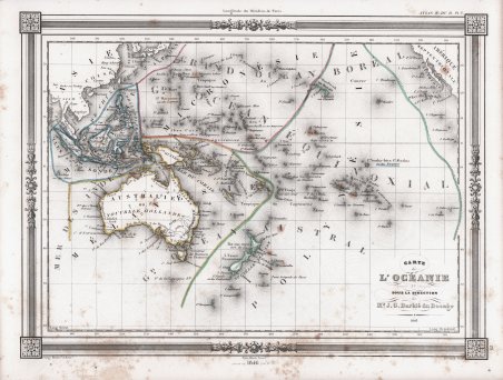
Carte de l'Océanie
Formas de Pago
- PayPal
- Tarjeta de crédito
- Transferencia Bancaria
- Pubblica amministrazione
- Carta del Docente
Detalles
- Año de publicación
- 1846
- Lugar de impresión
- Parigi
- Formato
- 335 X 255
- Grabadores
- Barbié du Bocage Jean-Denis
- Materia
- Pacifico e Oceania
Descripción
Carta dell'Oceania di J. G. Barbie du Bocage. Include Australia, Nuova Zelanda, Polinesia, Micronesia, Melanesia e Malesia. L'Australia è descritta come “pays inconnu” e alternativamente denominata come “Nuova Olanda”. Le Hawaii sono indicate come “Isole Sandwich”. Preparata da Barbie du Bocage per essere pubblicata nell'edizione del 1848 dell'Atlas Illustre pubblicato dalla casa editrice Maison Basset. La Maison Basset (1819 - 1865) è stata un'azienda editoriale francese attiva nella metà e nella fine del XIX secolo, fondata da André Basset (o Bassett), che iniziò a pubblicare mappe, stampe e libri intorno al 1768. La Maison Basset, o Chez Basset, è il marchio con cui gli eredi di Paul-André Basset (1785-1819) pubblicarono le opere di importanti cartografi e incisori francesi come Barbie du Bocage, A. Vuillemin, J. B. Charle, V. Levasseur, Tu. Duvotenay, H. Dufor, F. E. George e altri. La loro biblioteca di pubblicazioni è varia e vasta, ma fortemente incentrata su testi medici e scientifici, tra cui alcuni importanti atlanti. Jean Denis Barbie du Bocage (1760 - 1825) e suo figlio Jean-Guillaume Barbie du Bocage (1795 - 1848) furono cartografi e cosmografi francesi attivi a Parigi tra la fine del XVIII e l'inizio del XIX secolo. Il più anziano dei Barbie du Bocage, Jean Denis, si formò come cartografo e incisore nei laboratori di J. B. B. d'Anville. Jean Denis ricoprì la carica di Bibliotecario Reale di Francia, mentre Jean-Guillaume divenne Geographe du Ministere des Affaires Etrangeres. Incisione in rame con contorno originale a colori, alcune ossidazioni, per il resto buono stato di conservazione. Map of Oceania by J. G. Barbie du Bocage. Includes Australia, New Zealand, Polynesia, Micronesia, Melanesia and Malaysia. Australia is described as 'pays inconnu' and alternately labeled 'New Holland.' Hawaii shown as the 'Sandwich Islands.' Prepared by J. G. Barbie du Bocage for publication as plate no. 33 in Maison Basset's 1852 edition of ' Atlas Illustre Destine a l'enseignement de la Geographie elementaire. Maison Basset (1819 - 1865) was a French publishing concern active through the mid to late 19th century. The firm can trace their roots to André Basset (or Bassett) (fl. 1768 - 1784), who starting publishing maps, prints, and books around 1768. Maison Basset, also Chez Basset, is the imprint under which the heirs of Paul-André Basset (1785 - 1819) published the works of such prominent French cartographers and engravers as Barbie du Bocage, A. Vuillemin, J. B. Charle, V. Levasseur, Tu. Duvotenay, H. Dufor, F. E. George, and others. Their library of publications is diverse and vast, but heavily focused on medical and scientific texts, including several important atlases. Jean Denis Barbie du Bocage (1760 - 1825) and his son Jean-Guillaume Barbie du Bocage (1795 - 1848) were French cartographers and cosmographers active in Paris in the late 18th and early 19th centuries. The oldest of the Barbie du Bocage, Jean Denis, trained as a cartographer and engraver in the workshops of J. B. B. d'Anville. Jean Denis held the position of Royal Librarian of France while Jean-Guillaume became Geographe du Ministere des Affaires Etrangeres. Copper engraving with original outline colour, some foxing, otherwise good condition. Cfr.