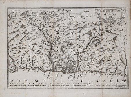
Carte des Environs de Genes
Carte des Environs de Genes | Grabados | Anonimo


Carte des Environs de Genes
Carte des Environs de Genes | Grabados | Anonimo
Formas de Pago
- PayPal
- Tarjeta de crédito
- Transferencia Bancaria
- Pubblica amministrazione
- Carta del Docente
Detalles
- Año de publicación
- 1780
- Formato
- 420 X 300
- Grabadores
- Anonimo
Descripción
Opera anonima, prima di indicazioni editoriali. In basso a destra la firma dell’incisore della lastra “W. fecit”. Carta della parte centrale della Liguria, raffigurante i dintorni di Genova; si estende ad Est fino a Recco, mentre ad Ovest include Voltri. Acquaforte, circa 1780/90, impressa su carta vergata coeva, più volte ripiegata e quindi con pieghe di carta, in ottimo stato di conservazione. Non siamo riusciti a trovare ulteriori informazioni su questa carta della Liguria, probabilmente tratta da un libro. Un alto esemplare della mappa è conservato alla BNF (dove non è indicato l’autore): https://catalogue.bnf.fr/ark:/12148/cb445009998 ' Rara. Anonymous work, without printing details. Bottom right is the signature of the plate engraver "W. fecit". Map of the central part of Liguria, depicting the environs of Genoa; extending east to Recco, and west to include Voltri. Etching, circa 1780/90, impressed on contemporary laid paper, folded several times and thus with paper creases, in excellent condition. We have not been able to find any further information on this map of Liguria, probably taken from a book. An example of the map is preserved at the BNF (where the author is not indicated): https://catalogue.bnf.fr/ark:/12148/cb445009998 Rare. Cfr.
