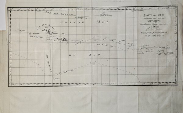
Carte des Isles D'Otahiti
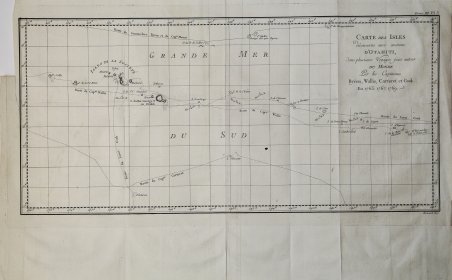
Carte des Isles D'Otahiti
Formas de Pago
- PayPal
- Tarjeta de crédito
- Transferencia Bancaria
- Pubblica amministrazione
- Carta del Docente
Detalles
- Año de publicación
- 1774
- Lugar de impresión
- Venezia
- Formato
- 510 X 240
- Grabadores
- COOK James
- Materia
- Pacifico e Oceania
Descripción
Carta geografica tratta dall'atlante della relazione di James Hawkesworth "Cartes et figures des voyages entrepris par ordre de sa Majesté Britannique pou fair des découvertes dans l'hémisphère méridional; exécutes par Byron, Carteret, Wallis & Cook dans les vaisseaux le Dauphin, Le Swallow & l'Endeavour" pubblicata in più edizioni di lingua francese, inglese, olandese ed italiano. Incisione in rame, in ottimo stato di conservazione. Map taken from the atlas by James Hawkesworth "Cartes et figures des voyages entrepris par ordre de sa Majesté Britannique pou fair des découvertes dans l'hémisphère méridional; exécutes par Byron, Carteret, Wallis & Cook dans les vaisseaux le Dauphin, Le Swallow & l'Endeavour" published in more edition in french, english, duth and italian. Fine map shows the explorations of Captain Cook, Captain Byron, Captain Wallis and Captain Carteret in the vicinity of Tahiti and the Society Islands from 1765 to 1769. Extends from Is. Scilly [i.e. the Scilly Islands] in the west and to I. Whitsunday de la Pentecote [i.e. the Whitsunday Island] in the east, from Is. du Disappointment [i.e. Disappointment Island] in the north to Ohetiroa in the south. Features the routes taken by these important explorers as the zig-zagged in and around the Society Islands. Depicts the island of Tahiti (Otaheite) as well as Bora Bora (Bolabola), Otaha, Marma, Ulietea, and others. Title in decorative script in the upper right quadrant. Copper engraving, in excellent condition. Cfr.