Carte des Pavillons Accompagnée d'Observations Pour en Faire Comprendre le Blazon et les Differentes Devises Aussy Bien Que
Carte des Pavillons Accompagnée d'Observations Pour en Faire Comprendre le Blazon et les Differentes Devises Aussy Bien Que | Grabados | CHATELAIN Henri Abraham

Carte des Pavillons Accompagnée d'Observations Pour en Faire Comprendre le Blazon et les Differentes Devises Aussy Bien Que
Carte des Pavillons Accompagnée d'Observations Pour en Faire Comprendre le Blazon et les Differentes Devises Aussy Bien Que | Grabados | CHATELAIN Henri Abraham
Formas de Pago
- PayPal
- Tarjeta de crédito
- Transferencia Bancaria
- Pubblica amministrazione
- Carta del Docente
Detalles
- Año de publicación
- 1720
- Lugar de impresión
- Amsterdam
- Formato
- 595 X 500
- Grabadores
- CHATELAIN Henri Abraham
- Materia
- Marine
Descripción
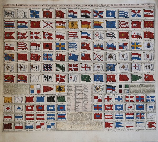
Interessante e decorativa tavola con le bandiere nautiche di 88 Paesi. Tratta dal monumentale Atlas Historique, pubblicato ad Amsterdam tra il 1705 e il 1720. La tavola è la n. 43 del settimo volume. Incisione in rame, finemente colorata a mano, in ottimo stato di conservazione. ' Molto decorativa. Henri Abraham Chatelain (1684 - 1743) era un pastore ugonotto di origini parigine. È meglio conosciuto come cartografo olandese e più specificamente per il suo contributo cartografico nell’Atlas Historique ' in sette volumi, pubblicato ad Amsterdam tra il 1705 e il 1720. Innovativo per il suo tempo, l'Atlas Historique ' combinava incisioni e opere d'arte con studi di geografia, storia, etnologia, araldica e cosmografia. Alcuni studiosi suggeriscono che l'Atlas Historique ' non fu compilato esclusivamente da Henri Chatelain, come si crede comunemente, ma piuttosto fu un'impresa familiare che coinvolse Henri, suo padre Zacharie e suo fratello, sempre Zacharie. Plate with 88 marine flags, including Malta, Turkey, Middelburg, Amsterdam, Portugal, Monaco, Tuscany, China, Nanking, the French Royal flag, French admiralty flag and merchant flags. ' In bottom part an explanation how to understand the coat of arms and divisions as well as an alphabetic table to easily find them. From the Chatelain's monumental Atlas Historique. The atlas was published in seven volumes between 1705 and 1720, with a second edition appearing in 1732. The maps were accompanied by information pertaining to cosmography, geography, history, chronology, genealogy, topography, heraldry, and costumes of the world. The maps in the Atlas Historique were mainly based on those of the French cartographer, Guillaume De L'Isle, but were presented by the Chatelain in an encyclopaedic form. Henri Abraham Chatelain (1684 - 1743) was a Huguenot pastor of Parisian origins. He is best known as a Dutch cartographer and more specifically for his cartographic contribution in the seminal seven volume ' Atlas Historique, published in Amsterdam between 1705 and 1720. Innovative for its time, the ' Atlas Historique ' combined fine engraving and artwork with scholarly studies of geography, history, ethnology, heraldry, and cosmography. Some scholarship suggests that the ' Atlas Historique ' was not exclusively compiled by Henri Chatelain, as is commonly believed, but rather was a family enterprise involving Henri, his father Zacharie and his brother, also Zacharie. Cfr.
