Carte Marine de l'Afrique Meridionale
Carte Marine de l'Afrique Meridionale
Formas de Pago
- PayPal
- Tarjeta de crédito
- Transferencia Bancaria
- Pubblica amministrazione
- Carta del Docente
Detalles
- Año de publicación
- 1749
- Lugar de impresión
- Berlino
- Formato
- 530 X 445
- Grabadores
- Brouckner (Bruckner) Isaac
- Descripción
- Tooley 83; Shirley BL, M.BROU-1a
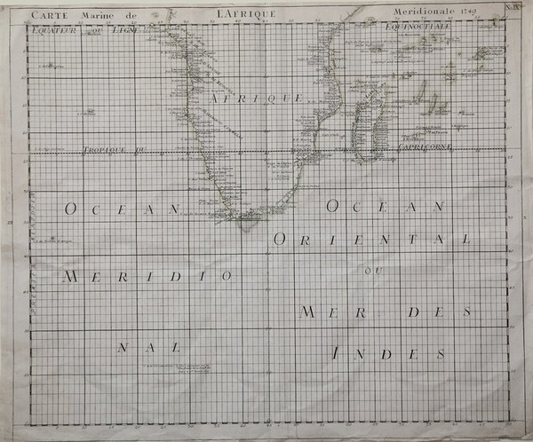
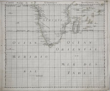
Descripción
Carta nautica pubblicata nel'atlante "Nouvel Atlas de Marine. Composé d’une Carte Generale, et de XII Cartes Particulieres, qui Representent Le Globe Terrestre…" di Isaac Brouckner (Bruckner) che rappresenta il primo atlante nautico prussiano, edito per la prima volta nel 1749.La carta generale e le 12 particolari dell'atlante, tutte in proiezione mercatoriana, delineate dal Brouckner, furono incise su rame da Nicolaus Frdr. Sauerbrey, attivo a Berlino. L'atlante è preceduto da un testo con la spiegazione per l'uso delle carte fornita in 4 lingue: tedesco, inglese, francese e olandese.Il progetto dell'atlante nautico fu concepito dall'Accademia delle Scienze di Berlino, e infatti l'opera reca la dedica alll'allora direttore Samuel Count von Schmettau.Per la realizzazione delle carte, Brouckner si servì delle più recenti fonti disponibili presso l'Accademia berlinese, con il risultato di un'opera assolutamente accurata e aggiornata.Si ha notizia di un'edizione olandese dell'atlante, pubblicata 10 anni dopo la prima, nel 1759. Mentre il testo introduttivo reca la data aggiornata al 1759, le carte recano invece la data 1749, come nella prima edizione.Questa carta dell'Africa meridionale costituisce la tavola 9 dell'opera.Incisione su rame, aggiunto l'angolo inferiore destro, in ottimo stato di conservazione. Map published in" Nouvel Atlas de Marine. Composé d’une Carte Generale, et de XII Cartes Particulieres, qui Representent Le Globe Terrestre…" by Isaac Brouckner (Bruckner), the first Prussian Maritime Atlas, published first time in 1749. Drawn up by order of the Academy of Sciences in Berlin and dedicated to its director, Samuel Count von Schmettau . 1 world map & 12 charts – all in Mercator projection – engraved by Nicolaus Frdr. Sauerbrey (map engraver and engraver of arms in Berlin, d. about 1771), with explanation & exercise for the use of the charts in all four languages : German , English , French, and Dutch.For the preparation of the atlas Brouckner could fall back upon all recent sources available at the Berlin Academy of Sciences and used these indeed – so Phillips – to the greatest benefit of the atlas:“ … prepared … by order of field-marshall count Samuel von Schmettau, who did so much in Prussia to raise the level of the scientific undertakings, not only theoretical but practical, of the Berlin Royal academy of sciences during the eighteenth century. In order that this atlas might be as complete as possible, Count von Schmettau placed at Brouckner’s disposal all the sheets and memoirs that were available, which were dealt with in a masterly way by the geographer, with the result that a most creditable marine atlas for the time was prepared, which certainly deserves to be designated as the first Prussian marine atlas . ”“A little-known Dutch edition of Isaac Brouckner’s Nouvel atlas de marine, first published in 1749, Berlin, was also added by purchase” (Imago Mundi IX [1952], 116) – , its charts still carry, irrespective of the typographical Dutch text dated 1759, the unchanged year 1749 of present first edition.This Africa's map is the plate 9 of the atlas.Copper engraving, added the lower right corner, otherwise in perfect condition. Cfr. Tooley 83; Shirley BL, M.BROU-1a