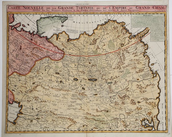
Carte Nouvelle de la Grande Tartarie ou de L'Empire du Grand Cham
Carte Nouvelle de la Grande Tartarie ou de L'Empire du Grand Cham | Grabados | CHATELAIN Henri Abraham


Carte Nouvelle de la Grande Tartarie ou de L'Empire du Grand Cham
Carte Nouvelle de la Grande Tartarie ou de L'Empire du Grand Cham | Grabados | CHATELAIN Henri Abraham
Formas de Pago
- PayPal
- Tarjeta de crédito
- Transferencia Bancaria
- Pubblica amministrazione
- Carta del Docente
Detalles
- Año de publicación
- 1708
- Lugar de impresión
- Amsterdam
- Formato
- 510 X 405
- Grabadores
- CHATELAIN Henri Abraham
Descripción
Carta geografica tratta dall'Atlas Historique, pubblicato ad Amsterdam tra il 1705 e il 1720. ' Incisione in rame, finemente colorata a mano, in perfette condizioni. Henri Abraham Chatelain (1684 - 1743) era un pastore ugonotto di origini parigine. È meglio conosciuto come cartografo olandese e più specificamente per il suo contributo cartografico nell’Atlas Historique ' in sette volumi, pubblicato ad Amsterdam tra il 1705 e il 1720. Innovativo per il suo tempo, l'Atlas Historique ' combinava incisioni e opere d'arte con studi di geografia, storia, etnologia, araldica e cosmografia. Alcuni studiosi suggeriscono che l'Atlas Historique ' non fu compilato esclusivamente da Henri Chatelain, come si crede comunemente, ma piuttosto fu un'impresa familiare che coinvolse Henri, suo padre Zacharie e suo fratello, sempre Zacharie. Map pf northern east Asia taken from "Atlas Historique". Henri Abraham Chatelain (1684 - 1743) was a Huguenot pastor of Parisian origins. He is best known as a Dutch cartographer and more specifically for his cartographic contribution in the seminal seven volume ' Atlas Historique, published in Amsterdam between 1705 and 1720. Innovative for its time, the ' Atlas Historique ' combined fine engraving and artwork with scholarly studies of geography, history, ethnology, heraldry, and cosmography. Some scholarship suggests that the ' Atlas Historique ' was not exclusively compiled by Henri Chatelain, as is commonly believed, but rather was a family enterprise involving Henri, his father Zacharie and his brother, also Zacharie. Copper engraving, in excellent condition. Cfr.
