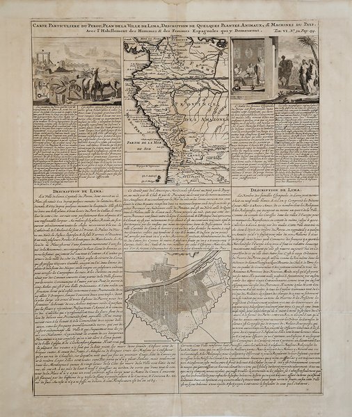
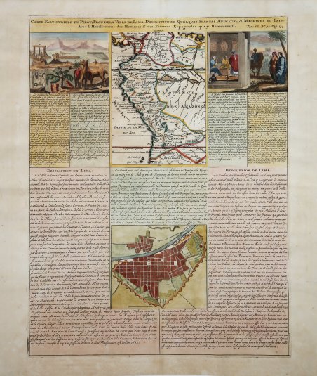
Carte Particuliere du Perou, Plan de la Ville de Lima, Description de Quelques Plantes, Animaux, & Machines du Pays
Carte Particuliere du Perou, Plan de la Ville de Lima, Description de Quelques Plantes, Animaux, & Machines du Pays
Formas de Pago
- PayPal
- Tarjeta de crédito
- Transferencia Bancaria
- Pubblica amministrazione
- Carta del Docente
Detalles
- Año de publicación
- 1708
- Lugar de impresión
- Amsterdam
- Formato
- 385 X 500
- Grabadores
- CHATELAIN Henri Abraham
- Idiomas
- Italiano
Descripción
Carte Particuliere du Perou, Plan de la Ville de Lima, Description de quelques Plantes,Animaux, & Machines du Pays. Avec l'Habillement des Hommes & des Femmes Espagnoles qui y Demeurent. Pianta dettagliata di Lima e carta regionale del Perù, pubblicata nei 7 volumi dell'Atlas Historique di Henri Chatelain. Questo foglio in folio contiene due mappe e due incisioni relative al Perù, accompagnate da un testo francese che le descrive. La carta superiore è un'immagine della costa nord-occidentale del Sud America, che si estende da Panama al Cile, e comprende varie città, fiumi, catene montuose e laghi. La mappa inferiore offre una vista a volo d'uccello della città di Lima, in Perù. Sono affiancate da due incisioni che mostrano le piante, gli animali, le macchine e le persone della regione. Henri Abraham Chatelain (1684 - 1743) era un pastore ugonotto di origini parigine. È meglio conosciuto come cartografo olandese e più specificamente per il suo contributo cartografico nell’Atlas Historique ' in sette volumi, pubblicato ad Amsterdam tra il 1705 e il 1720. Innovativo per il suo tempo, l'Atlas Historique ' combinava incisioni e opere d'arte con studi di geografia, storia, etnologia, araldica e cosmografia. Alcuni studiosi suggeriscono che l'Atlas Historique ' non fu compilato esclusivamente da Henri Chatelain, come si crede comunemente, ma piuttosto fu un'impresa familiare che coinvolse Henri, suo padre Zacharie e suo fratello, sempre Zacharie. Acquaforte, finemente colorata a mano, in ottimo stato di conservazione. Carte Particuliere du Perou, Plan de la Ville de Lima, Description de quelques Plantes,Animaux, & Machines du Pays. Avec l'Habillement des Hommes & des Femmes Espagnoles qui y Demeurent. Detailed plan of Lima and regional map of Peru, published in Henri Chatelain's 7 volume Atlas Historique. This folio sheet contains two maps and two engravings concerning Peru with accompanying French text that describes them. The top map is an image of the northwest coast of South America, which stretches from Panama to Chile, and includes various cities, rivers, mountain ranges, and lakes. The bottom map offers a bird’s eye view of the city of Lima, Peru. They are flanked by two engravings, which show the plants, animals, machines, and people of the region. Henri Abraham Chatelain (1684 - 1743) was a Huguenot pastor of Parisian origins. He is best known as a Dutch cartographer and more specifically for his cartographic contribution in the seminal seven volume ' Atlas Historique, published in Amsterdam between 1705 and 1720. Innovative for its time, the ' Atlas Historique ' combined fine engraving and artwork with scholarly studies of geography, history, ethnology, heraldry, and cosmography. Some scholarship suggests that the ' Atlas Historique ' was not exclusively compiled by Henri Chatelain, as is commonly believed, but rather was a family enterprise involving Henri, his father Zacharie and his brother, also Zacharie. Copper engraving, fine later hand colour, in good condition. Cfr.