Die sichbare Seite der Mond-Oberfläche bei voller Beleuchtung
Die sichbare Seite der Mond-Oberfläche bei voller Beleuchtung | Grabados | Perthes Justus
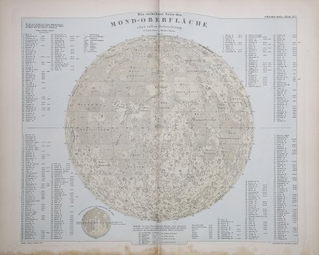
Die sichbare Seite der Mond-Oberfläche bei voller Beleuchtung
Die sichbare Seite der Mond-Oberfläche bei voller Beleuchtung | Grabados | Perthes Justus
Formas de Pago
- PayPal
- Tarjeta de crédito
- Transferencia Bancaria
- Pubblica amministrazione
- Carta del Docente
Detalles
- Año de publicación
- 1852
- Lugar de impresión
- Gotha
- Formato
- 435 X 350
- Grabadores
- Perthes Justus
- Materia
- Carte Celesti
Descripción
Dettagliata carta topografica della superficie lunare, circondata da un vasto indice descrittivo. Carta lunare disegnata da Joh. Carl Ausfeld dal modello di Beer e Mädler, qui proiettata verso nord e quindi opposta alle proiezioni originali di Beer e Mädler. Scala circa 1:13.000.000. I valori di altezza e profondità di 198 elementi topografici sono indicati in piedi di Parigi. In basso è presente una piccola illustrazione che mostra i cambiamenti giornalieri della fase lunare. Come detto, deriva dal rilievo di Wilhelm Beer, (1797-1850) e Johann Heinrich Mädler, (1794-1874), [Mappa selenographica, Berlin, Apud Simon Schropp & Soc., 1834]. La carta di Beer e Mädler ha l'onore di essere la prima mappa della Luna in grande scala ad essere basata su precise misurazioni micrometriche. Beer era un banchiere e un osservatore amatoriale della Luna e possedeva un bel rifrattore Fraunhofer. Mädler, invece, era un astronomo che fece coppia con Beer al fine di misurare la posizione di ogni formazione lunare sulla base di un gran numero di punti di controllo. La mappa, risultato di quattro anni di lavoro, è divisa in quattro sezioni ed ha un diametro pari a quasi un metro. Nel 1837 fu seguita da un volume di testo accompagnatorio. Questa mappa fu senza dubbio la più autorevole pubblicazione lunare del secolo e costituì la base di partenza per le successive carte di T.W. Webb and Edmund Neison. La carta è parte dell “Hand-Atlas di Adolf Stieler (Gotha 1775 - †1836), edito dalla casa editrice Justus Perthes di Gotha, che fu pubblicato in dieci edizioni dal 1817 al 1944. Viene considerato il primo atlante moderno in considerazione della precisione geografica e per la qualità grafica: la bozza di ogni singola tavola richiedeva un anno e mezzo di lavoro. Cromolitografia, leggera macchia di umidità in basso, per il resto in ottimo stato di conservazione. Detailed topographic map of the lunar surface, surrounded by an extensive descriptive index. Moon map drawn by Joh. Carl Ausfeld from Beer and Mädler's model, here projected northward and thus opposite to Beer and Mädler's original projections. Scale approximately 1:13,000,000. Height and depth values of 198 topographic features are given in feet of Paris. At the bottom is a small illustration showing daily changes in lunar phase. As mentioned, it is derived from the survey of Wilhelm Beer, (1797-1850) and Johann Heinrich Mädler, (1794-1874), [Mappa selenographica, Berlin, Apud Simon Schropp & Soc., 1834]. Beer and Mädler's map has the honor of being the first large-scale map of the Moon to be based on precise micrometer measurements. Beer was a banker and amateur observer of the Moon and owned a fine Fraunhofer refractor. Mädler, on the other hand, was an astronomer who partnered with Beer in order to measure the position of each lunar formation based on a large number of control points. The map, the result of four years of work, is divided into four sections and is nearly a meter in diameter. In 1837 it was followed by a volume of accompanying text. This map was undoubtedly the most authoritative lunar publication of the century and formed the basis for later maps by T.W. Webb and Edmund Neison. The map is part of Adolf Stieler "s (Gotha 1775 - †1836) Hand-Atlas, published by the Justus Perthes publishing house in Gotha, which was published in ten editions from 1817 to 1944. It is considered the first modern atlas because of its geographical accuracy and graphic quality: the draft of each individual plate took a year and a half to complete. Chromolithography, slight moisture stain at bottom, otherwise in very good condition. Cfr.
