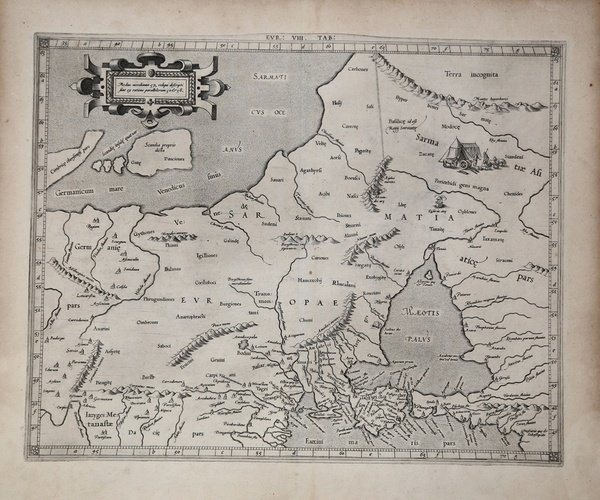
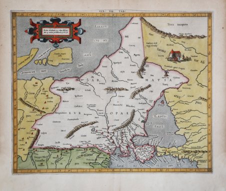
EUR: VIII TAB: (Europae Tabula Octava)
EUR: VIII TAB: (Europae Tabula Octava)
Formas de Pago
- PayPal
- Tarjeta de crédito
- Transferencia Bancaria
- Pubblica amministrazione
- Carta del Docente
Detalles
- Año de publicación
- 1578
- Lugar de impresión
- Colonia
- Formato
- 436 X 347
- Grabadores
- MERCATOR (Kremer) Gerard
- Idiomas
- Italiano
Descripción
Carta tolemaica dell'antica regione della Sarmazia corrispondente all'attuale territorio di Ucraina e Russia. Questa regione era conosciuta in epoca romana come Sarmatia Europae e rappresentava il limite della conoscenza accurata della geografia del mondo romano verso nord-est. La mappa è particolarmente dettagliata nelle aree lungo la costa del Mar Nero, comprese l'Ucraina e la Crimea. Tuttavia, il Mare d'Azov (allora noto come Lago Maeotiano) è fortemente distorto e tutti i punti a est sembrano essere dovuti più a voci che a contatti reali. Mappa tratta dal ' Cl. Ptolemaei Alexandrini, Geographiae Libri Octo, ' pubblicata prima a Colonia da Gottfried von Kempen (1578) e poi ristampata dallo stesso editore nel 1584 (Van der Krogt 1, 502) e poi da Isaac Elsevier per il ' Theatrum Geographiae veteris ' di Petrus Bertius (Leyden 1618). Di tutte le edizioni di Tolomeo, quella di Gerard Kremer (Mercatore), pubblicata nel 1578, e forse tecnicamente la più bella. A questo punto la ' Geografia ' di Tolomeo perdeva però ogni pretesa di “attualità”, laddove lo scopo di Mercatore era quello di produrre un atlante del mondo classico che servisse da complemento al suo atlante moderno (per tale ragione egli aveva tentato di recuperare la forma originale dell’atlante tolemaico, scartandone le moderne accrezioni). L'interpretazione di Mercatore del testo tolemaico, per le 28 carte che illustrano la sua ' Geographia ' è stata, quindi, una delle più veritiere. Egli aveva passato 13 anni a ricercare, disegnare e incidere le carte, rinunciando anche alla pubblicazione delle sue carte “moderne”. Questo esemplare proviene dal ' Theatrum Geographia Veteris ' di Petrus Bertius edita a Leida nel 1618, che combina il Tolomeo di Mercator, le 8 tavole del Moretus per rappresentare la ' Tabula Peutingeriana ' e 14 mappe storiche delle regioni d'Europa derivate dal ' Parergon ' di Ortelius. Acquaforte su rame finemente colorata a mano, in ottime condizioni. ' Ptolemaic map of ancient Sarmatia the region between the Baltic, Adriatic and Black Seas. ' This region was known in the Roman period as Sarmatia Europae, and it represented the limit of the Roman world’s accurate knowledge of geography to the northeast. The map is particularly detailed in those areas along the Black Sea coast, including the Ukraine and the Crimea. However, the Sea of Azov (then known as the Maeotian Lake) is greatly distorted, and all points east appear to owe more to rumor than to actual contact. Map taken from the ' Cl. Ptolemaei Alexandrini, Geographiae Libri Octo, ' first published in Cologne by Gottfried von Kempen (1578) and then reprinted by the same publisher in 1584 (Van der Krogt 1, 502) and then by Isaac Elsevier for the Petrus Bertius’ ' Theatrum Geographiae veteris ' (Leyden 1618). Mercator's interpretation of the 28 Ptolemaic text was possibly one of the truest undertaken up until that time. He had spent 13 years researching, drawing and engraving the maps at much commercial sacrifice to himself, having seen Ortelius's ' Theatrum ' and De Jodes ' Speculum ' published, to become both technical and commercial successes. In later life he devoted himself to his edition of the maps in Ptolemy's ' Geographia, reproduced in his own engraving as nearly as possible in their original form. This example comes from the ' Theatrum Geographia Veteris ' of Petrus Bertius published in Leiden in 1618, which combines Mercator's Ptolemy, the 8 plates of Moretus to represent the ' Tabula Peutingeriana ' and 14 historical maps of the regions of Europe derived from the ' Parergon ' of Ortelius. Copperplate with fine later hand colour, in good condition. Cfr.