Europae
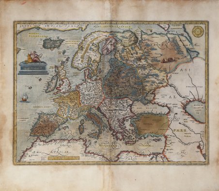
Europae
Formas de Pago
- PayPal
- Tarjeta de crédito
- Transferencia Bancaria
- Pubblica amministrazione
- Carta del Docente
Detalles
- Año de publicación
- 1584
- Lugar de impresión
- Anversa
- Formato
- 470 X 345
- Grabadores
- ORTELIUS Abraham
Descripción
Bella carta generale dell’Europa di Abraham Ortelius, basata su molteplici fonti cartografiche: “Gerard Mercator's 1554 map of Europe. Greenland from Mercator's 1569 world map. Both these maps for Iceland. Great Britain after Mercator's 1564 Great Britain map. Scandinavia from Olaus Magnus' 1539 Scandinavia map. Russia is based on Jenkinson's 1562 Russia map. South-East part of this map based on Gastaldi's first map of Asia of 1559. Parts of the North African coast are based on Gastaldi's Africa map of 1664. (Meurer p. 36, Karrow 56/13, and 53/1 p. 386, 363). Ortelius himself mentions in his Catalogus Auctorum also the Europa maps of Apianus, Cornelius Antonii of Frankfurt, Aurigarius Lucas printed in Amsterdam, Ioannes Bucius Ænicola of Paris, Jacob Homem Lusitanus printed in Venice, Jodocus Hondius, Ioannes Dominicus Methoneus of Venice, Nicolaus Nicolay printed in Antwerp by Ioannes Stelsium, Vopelius, Waldseemüller, Christoph Zell and Heinrich Zell of Nurnberg” (cfr. Van den Broecke, Ortelius, n. 5). Esemplare della seconda lastra che compare nell'edizione successiva al 1584 del Theatrum Orbis Terrarum. Dalla rara edizione italiana del Theatrum Orbis Terrarum stampata ad Anversa da Jean Baptiste Vrients nel 1608 e poi nel 1612. Il Theatrum Orbis Terrarum ' è considerato il primo vero “atlante” moderno. L’opera fu pubblicata in 7 lingue e 36 edizioni, per il quale – nel 1570 - Ortelius ottenne il ' privilegio, ovvero una sorta di diritto d'autore che impediva ad altri cartografi di pubblicare i propri lavori. Il ' Theatrum ' rappresentava il lavoro più avanzato del lavoro della descrizione cartografica. L’Ortelius vi raccolse il sapere geografico e cartografico del suo tempo, proponendo in 147 spettacolari tavole incise l’immagine più fedele del mondo allora conosciuto e, in alcune straordinarie “carte storiche”, regioni e itinerari tratti dalla letteratura, dalla mitologia, dalla tradizione. Ortelius fu anche il primo a citare le fonti, menzionando i nomi dei cartografi nel “catalogus auctorum”. Dal 1598 al 1612 le edizioni postume del ' Theatrum ' furono realizzate dal suo collaboratore Johannes Baptiste Vrients. Acquaforte, finemente colorata in epoca, restauri lungo la piega centrale e al testo al verso, per il resto in buono stato di conservazione. Bibliografia Van den Broecke, Ort, 5; Koeman/Meurer: 110, Karrow: 1/10a, van der Krogt AN: 1000:31B. Fine general map of Europe based on multiple cartographic sources: “Gerard Mercator's 1554 map of Europe. Greenland from Mercator's 1569 world map. Both these maps for Iceland. Great Britain after Mercator's 1564 Great Britain map. Scandinavia from Olaus Magnus' 1539 Scandinavia map. Russia is based on Jenkinson's 1562 Russia map. South-East part of this map based on Gastaldi's first map of Asia of 1559. Parts of the North African coast are based on Gastaldi's Africa map of 1664. (Meurer p. 36, Karrow 56/13, and 53/1 p. 386, 363). Ortelius himself mentions in his Catalogus Auctorum also the Europa maps of Apianus, Cornelius Antonii of Frankfurt, Aurigarius Lucas printed in Amsterdam, Ioannes Bucius Ænicola of Paris, Jacob Homem Lusitanus printed in Venice, Jodocus Hondius, Ioannes Dominicus Methoneus of Venice, Nicolaus Nicolay printed in Antwerp by Ioannes Stelsium, Vopelius, Waldseemüller, Christoph Zell and Heinrich Zell of Nurnberg” (cfr. Van den Broecke, Ortelius, n. 5). Second plate of the Europe map by Ortelius, published in the Theatrum Orbis Terrarum ' printed after 1584. From the rare Italian edition of ' Theatrum Orbis Terrarum ' printed in Antwerp by Jean Baptiste Vrients in 1608 and then in 1612. The ' Theatrum Orbis Terrarum is considered the first true modern "Atlas". The work was published in 7 languages and 36 editions, for which - in 1570 - Ortelius obtained the privilege, a kind of copyright that prevented other cartographers from publishing his works. The ' Theatrum ' represented the most advanced work of cartographic description. Ortelius collected in it the geographical and cartographic knowledge of his time, proposing in 147 spectacular engraved plates the most faithful image of the world then known and, in some extraordinary "historical maps", regions and routes taken from literature, mythology, tradition. Ortelius was also the first to cite sources, mentioning the names of cartographers in the "catalogus auctorum". From 1598 to 1612 the posthumous editions of the ' Theatrum ' were made by his collaborator Johannes Baptiste Vrients. Etching, finely colored at the time, restorations along the central fold and on the text on the reverse, otherwise in good condition. Bibliografia Van den Broecke, Ort, 5; Koeman/Meurer: 110, Karrow: 1/10a, van der Krogt AN: 1000:31B. Cfr.