Detalles
Lugar de impresión
Norimberga
Grabadores
HOMANN Johann Baptist
Descripción
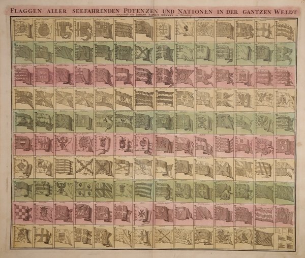
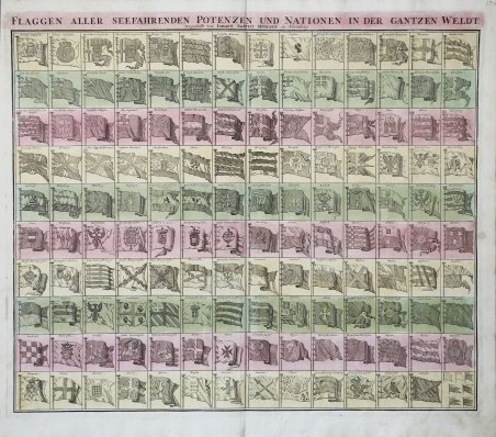
La tavola presenta 139 bandiere di varie nazioni, fazioni e compagnie commerciali. Tra le bandiere più interessanti ci sono quelle della Compagnia Olandese delle Indie Occidentali (G.W.C. /Geoctroyeerde Westindische Compagnie) e della Compagnia Olandese delle Indie Orientali (V.O.C. / Vereenigde Oostindische Compagnie). Il primo posizionamento delle bandiere inglesi nel quadrante superiore sinistro suggerisce che questa carta potrebbe essere stata copiata da una fonte inglese, anche se probabilmente derivata da una carta delle bandiere olandesi pubblicata da Cornelis Danckerts intorno al 1700. Johann Baptist Homann è stato un geografo e cartografo tedesco; nel 1702 fondò la sua casa editrice. Homann acquisì fama come uno dei principali cartografi tedeschi, e nel 1715 fu nominato geografo imperiale dall'imperatore Carlo VI. Nello stesso anno fu anche nominato membro dell'Accademia Prussiana delle Scienze a Berlino. Nel 1716 Homann pubblicò il suo capolavoro Grosser Atlas ueber die ganze Welt. Numerose mappe furono redatte in collaborazione con l'incisore Christoph Weigel. Homann morì a Norimberga nel 1724. Gli successe suo figlio Johann Christoph (1703-1730). L'azienda continuò dopo la sua morte come azienda degli eredi Homann, gestita da Johann Michael Franz e Johann Georg Ebersberger. Dopo successivi cambiamenti nella gestione, l'azienda si sciolse nel 1852. Acquaforte, con bella coloritura editoriale, un piccolo strappo nel margine bianco inferiore, per il resto in ottime condizioni. A very attractive flag chart issued by Johann Baprist Homann. The plate features 139 flags of various nations, factions, and trading companies. Among the more interesting flags are those of the Dutch West India Company (G.W.C. /Geoctroyeerde Westindische Compagnie) and the Dutch East India Company (V.O.C. / Vereenigde Oostindische Compagnie). The premier placement of English flags in the upper left quadrant suggest that this chart may have been copied from an English source. This map is probably derived from a Dutch flag chart issued by Cornelis Danckerts c. 1700. Johann Baptist Homann was a German geographer and cartographer; in 1702 he founded his own publishing house. Homann acquired renown as a leading German cartographer, and in 1715 was appointed Imperial Geographer by Emperor Charles VI. In the same year he was also named a member of the Prussian Academy of Sciences in Berlin. In 1716 Homann published his masterpiece Grosser Atlas ueber die ganze Welt; numerous maps were drawn up in cooperation with the engraver Christoph Weigel the Elder. Homann died in Nuremberg in 1724 and was succeeded by his son Johann Christoph (1703-1730). The company carried on upon his death as Homann heirs company, managed by Johann Michael Franz and Johann Georg Ebersberger. After subsequent changes in management the company folded in 1852. ' Etching with fine original colour, a small tear in the white bottom margin, otherwise in good condition. Cfr.

 Descubre cómo utilizar
 Descubre cómo utilizar