Florentini Dominii, Fidelissima et Nova Descriptio
Florentini Dominii, Fidelissima et Nova Descriptio | Grabados | ORTELIUS Abraham


Florentini Dominii, Fidelissima et Nova Descriptio
Florentini Dominii, Fidelissima et Nova Descriptio | Grabados | ORTELIUS Abraham
Formas de Pago
- PayPal
- Tarjeta de crédito
- Transferencia Bancaria
- Pubblica amministrazione
- Carta del Docente
Detalles
- Año de publicación
- 1595
- Lugar de impresión
- Anversa
- Formato
- 470 X 345
- Grabadores
- ORTELIUS Abraham
- Descripción
- Van den Broecke 131.
Descripción
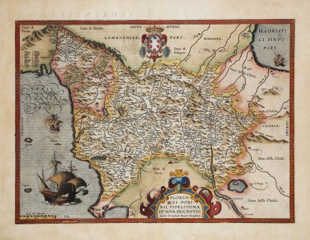
Prima derivazione della rarissima carta di Stefano Buonsignori del 1584, inserita nel Theatrum Orbis Terrarum di Ortelius a partire solo dal 1595. Il ' Theatrum Orbis Terrarum ' è considerato il primo vero “atlante” moderno. L’opera fu pubblicata in 7 lingue e 36 edizioni, per il quale – nel 1570 - Ortelius ottenne il ' privilegio, ovvero una sorta di diritto d'autore che impediva ad altri cartografi di pubblicare i propri lavori. Il ' Theatrum ' rappresentava il lavoro più avanzato del lavoro della descrizione cartografica. L’Ortelius vi raccolse il sapere geografico e cartografico del suo tempo, proponendo in 147 spettacolari tavole incise l’immagine più fedele del mondo allora conosciuto e, in alcune straordinarie “carte storiche”, regioni e itinerari tratti dalla letteratura, dalla mitologia, dalla tradizione. Ortelius fu anche il primo a citare le fonti, menzionando i nomi dei cartografi nel “catalogus auctorum”. Dal 1598 al 1612 le edizioni postume del ' Theatrum ' furono realizzate dal suo collaboratore Johannes Baptiste Vrients. Magnifica prova, in perfetto stato di conservazione. Scarce map of the Province of Florence in Tuscany, first issued in in the Vrients edition of Ortelius' Theatrum Orbis Terrarum in 1595.The map is centered on the city of Florence and extends to Liguria, the Apennine Mountains, the Adriatic Coast, Siena and Lago di Perugia. The map is based upon Stefano Buonsignori's map of Florence and surroundings, engraved in 1584 by Domenico Vito. The map was sent to Ortelius by Marcarius in late 1594 or early 1595, as there exists a letter from Marcarius to Ortelius dated March 1595 which inquires whether Ortelius had received the map. The map identifies Stephanus Monachus of Orivieti as the maker. The ' Theatrum Orbis Terrarum ' is considered the first true modern "Atlas". The work was published in 7 languages and 36 editions, for which - in 1570 - Ortelius obtained the privilege, a kind of copyright that prevented other cartographers from publishing his works. The ' Theatrum ' represented the most advanced work of cartographic description. Ortelius collected in it the geographical and cartographic knowledge of his time, proposing in 147 spectacular engraved plates the most faithful image of the world then known and, in some extraordinary "historical maps", regions and routes taken from literature, mythology, tradition. Ortelius was also the first to cite sources, mentioning the names of cartographers in the "catalogus auctorum". From 1598 to 1612 the posthumous editions of the ' Theatrum ' were made by his collaborator Johannes Baptiste Vrients. Copper engraving, contemporary coloring, in good condition. Cfr. Van den Broecke 131.
