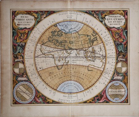
Hemisphaerium Orbis Antiqui cum Zonis, Circulis et situ popolorum diverso(rum)
Hemisphaerium Orbis Antiqui cum Zonis, Circulis et situ popolorum diverso(rum)
Formas de Pago
- PayPal
- Tarjeta de crédito
- Transferencia Bancaria
- Pubblica amministrazione
- Carta del Docente
Detalles
- Año de publicación
- 1660
- Lugar de impresión
- Amsterdam
- Formato
- 520 X 422
- Grabadores
- CELLARIUS Andreas
- Materia
- Carte Celesti
- Descripción
- Gent, R.H. van, De hemelatlas van Andreas Cellarius: Het meesterwerk van een vergeten Hollandse kosmograaf, Caert-Thresoor, 19 (2000), 9-25; Krogt, P.C.J. van der, Koeman, Atlantes Neerlandici: New Edition pp. 270, 278 & 513-518.
Descripción
Emisfero terrestre orientale di Andreas Cellarius, nel quale vengono mostrate le zone climatiche e le zone popolate del Vecchio Mondo. La carta è tratta dalla celebre ' Atlas Coelestis Seu Harmonia Macrocosmica ' del Cellarius, il più importante atlante celeste mai pubblicato. ' L' ' Harmonia Macrocosmica ' venne pubblicata nel 1660 (una ristampa venne eseguita nel 1661) da Johannes Janssonius, il noto editore di Amsterdam, quale supplemento al suo ' Atlas Novus. Cellarius aveva già iniziato a lavorare a questo atlante prima del 1647, e nelle sue intenzioni doveva essere un’introduzione ad un trattato in due volumi sulla cosmografia, ma la seconda parte non venne mai pubblicata. Incisione in rame, piccoli margini, magnifica coloritura coeva con ritocchi, in ottime condizioni. Prima edizione. Andreas Cellarius's Western Hemisphaer showing the climate zones and population. From ' Atlas Coelestis Seu Harmonia Macrocosmica ' del Cellarius, first published by Janssonius in 1660. His connection with the Janssonius publishing firm dates from around 1645. In this year Jodocus Janssonius, Johannes’s son, published Cellarius’s ' Architectura Militaris, a work on fortifications. In 1652 the Amsterdam publisher Gillis Jansz. Valckenier published Cellarius's ' Regni Poloniae … ' with 21 maps. In 1660, Joannes Janssonius added a celestial atlas to his Atlas Major, the beautiful ' Harmonia Macrocosmica ' by Andreas Cellarius. In 1661 the atlas was republished as a separate publication. The plates of the Harmonia Macrocosmica were reprinted (without the Latin commentary) in 1708 by the Amsterdam publishers Valk and Schenk. The ' Harmonia Macrocosmica ' is the most beautiful celestial atlas ever published and is one of the notable masterworks from the Golden Age of Dutch cartography. The first part of the atlas contains engravings depicting the world systems of Claudius Ptolemy, Nicolaus Copernicus, and Tycho Brahe. At the end are star maps of the classical and further constellations. Copperplate with original hand colour, touched, in good condition. Cfr. Gent, R.H. van, De hemelatlas van Andreas Cellarius: Het meesterwerk van een vergeten Hollandse kosmograaf, Caert-Thresoor, 19 (2000), 9-25; Krogt, P.C.J. van der, Koeman, Atlantes Neerlandici: New Edition pp. 270, 278 & 513-518.