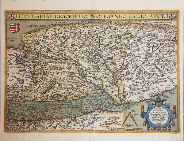
Hungariae Descriptio, Wolfgango Lazio Auct.
Hungariae Descriptio, Wolfgango Lazio Auct.
Formas de Pago
- PayPal
- Tarjeta de crédito
- Transferencia Bancaria
- Pubblica amministrazione
- Carta del Docente
Detalles
- Año de publicación
- 1570
- Lugar de impresión
- Anversa
- Formato
- 500 X 360
- Grabadores
- ORTELIUS Abraham
- Descripción
- M. Van den Broecke "Ortelius Atlas Maps" (2011), n. 150.
Descripción
Carta dell'Ungheria tratta ' dal Theatrum Orbis Terrarum, edizione spagnola del 1612. La mappa, come accreditato nel cartiglio, deriva dall'opera di Wolfgang Latius, una carta murale in 5 fogli del 1556 (Karrow 49/7, p. 338, Meurer p. 182-183). Tuttavia, nel "Catalogus Auctorum", Ortelius cita vari altri autori che hanno realizzato una carta dell'Ungheria, come Georgius Tanesterus Collimitus o Georg Tanstetter nel 1522, dopo Lazarus. Ioannes Cuspinianus aggiunse varie caratteristiche e Apianus la pubblicò nel 1528. Lazius revisionò questa mappa nel 1552. Nel "Catalogus Auctorum" Ortelius cita anche le mappe dell'Ungheria di Matthias Cinthius o Zyndt di Norimberga del 1567, Jacobus Gastaldi e Ioannes Sambucus. Il ' Theatrum Orbis Terrarum ' è considerato il primo vero “atlante” moderno. L’opera fu pubblicata in 7 lingue e 36 edizioni, per il quale – nel 1570 - Ortelius ottenne il ' privilegio, ovvero una sorta di diritto d'autore che impediva ad altri cartografi di pubblicare i propri lavori. Il ' Theatrum ' rappresentava il lavoro più avanzato del lavoro della descrizione cartografica. L’Ortelius vi raccolse il sapere geografico e cartografico del suo tempo, proponendo in 147 spettacolari tavole incise l’immagine più fedele del mondo allora conosciuto e, in alcune straordinarie “carte storiche”, regioni e itinerari tratti dalla letteratura, dalla mitologia, dalla tradizione. Ortelius fu anche il primo a citare le fonti, menzionando i nomi dei cartografi nel “catalogus auctorum”. Dal 1598 al 1612 le edizioni postume del ' Theatrum ' furono realizzate dal suo collaboratore Johannes Baptiste Vrients. Incisione in rame, eccellente coloritura coeva, in ottimo stato di conservazione. Bibliografia Van den Broecke, Ortelius Maps, n. 150, IV/V; Gròf (1979) "The Map Collector" 6:2-11; (1992) "Cart. Hung". 1:26-36 Map of Hungary taken from Theatrum Orbis Terrarum, Spanish edition of 1612. A map of the northern Balkans, from Vienna in the west to Transylvania in the east, and from Bosnia in the south to Slovakia in the north. Hungary and the surrounding territory were fragmented in the sixteenth century, fought over by the Austrian Hapsburgs and the Ottoman Turks. Buda (Budapest) was taken by the Turks in 1541.Compiled after the map of Wolfgang Lazius (1556) 5-sheet wall map (Karrow 49/7, p. 338, Meurer p. 182-183). In the "Catalogus Auctorum" Ortelius mentions various other authors who made a Hungary map, viz. Georgius Tanesterus Collimitus or Georg Tanstetter in 1522, after Lazarus. Ioannes Cuspinianus added various features, and Apianus published it in 1528. Lazius revised this map in 1552. Ortelius also mentions in the "Catalogus Auctorum" Hungary maps by Matthias Cinthius or Zyndt of Nurnberg 1567, Jacobus Gastaldi and Ioannes Sambucus. Map taken from the ' Theatrum Orbis Terrarum, which is considered the first true modern "Atlas". The work was published in 7 languages and 36 editions, for which - in 1570 - Ortelius obtained the privilege, a kind of copyright that prevented other cartographers from publishing his works. The ' Theatrum ' represented the most advanced work of cartographic description. Ortelius collected in it the geographical and cartographic knowledge of his time, proposing in 147 spectacular engraved plates the most faithful image of the world then known and, in some extraordinary "historical maps", regions and routes taken from literature, mythology, tradition. Ortelius was also the first to cite sources, mentioning the names of cartographers in the "catalogus auctorum". From 1598 to 1612 the posthumous editions of the ' Theatrum ' were made by his collaborator Johannes Baptiste Vrients. Copper engraving, fine contemporary coloring, very good condition. Bibliografia Van den Broecke, Ortelius Maps, n. 150, IV/V; Gròf (1979) "The Map Collector" 6:2-11; (1992) "Cart. Hung". 1:26-36 Cfr.