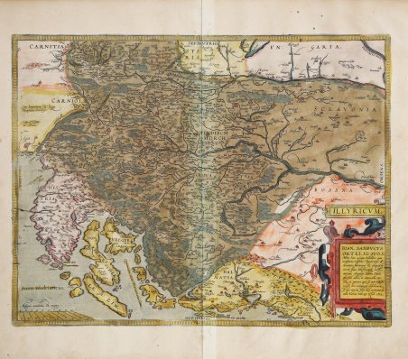
' ILLYRICUM. IOAN. SAMBVCVS | ORTELIO SVO S. | "Mitto hanc quoque tabellam qua | neceßaria confinia Pannoniæ de:|clarantur, fluuiorum & aliquot lo:|corum situs, Hirschvogelij recte | mutaui, Angelini autem studio | plurima adieci, et interualla cor:|rexi, vt parum quis si cum Hirsch:|vogelij hæc coniungat desiderarit, | si qui errores sint, dies certiora do:|cebit, Viennæ, Vale, 25 October 1572". In alto a sinistra "Cum Imperatoriæ et Regiæ | Maiestatis Priuilegio". Come indicato nel cartiglio con il titolo, le fonti cartografiche sono la carta di Johann Sambucus del 1572, basata su quella di Hirschvogel del 1565 (Karrow 40/9.1 p. 299-300, 461, Meurer p. 227). Come indicato nel titolo, Ioannes Sambucus invia una carta accompagnata da una lettera all'amico Ortelius: “invio anche una modesta rappresentazione in cui vengono descritti i confini necessari della Pannonia, nonché la posizione dei fiumi e di alcune località. Quelli forniti da Hirschvogel li ho modificati e a quelli di Angelino ne ho aggiunti alcuni, e ho corretto alcune distanze in modo che, confrontandoli con quelli di Hirschvogel, che contengono alcuni errori, possa conoscere la verità con maggiore certezza. Vienna, addio, 25 ottobre 1572”. Mappa tratta dal Theatrum Orbis Terrarum di Abraham Ortelius, edizione italiana del 1608 stampata da Johann Baptiste Vrients. Il ' Theatrum Orbis Terrarum ' è considerato il primo vero “atlante” moderno. L’opera fu pubblicata in 7 lingue e 36 edizioni, per il quale – nel 1570 - Ortelius ottenne il ' privilegio, ovvero una sorta di diritto d'autore che impediva ad altri cartografi di pubblicare i propri lavori. Il ' Theatrum ' rappresentava il lavoro più avanzato del lavoro della descrizione cartografica. L’Ortelius vi raccolse il sapere geografico e cartografico del suo tempo, proponendo in 147 spettacolari tavole incise l’immagine più fedele del mondo allora conosciuto e, in alcune straordinarie “carte storiche”, regioni e itinerari tratti dalla letteratura, dalla mitologia, dalla tradizione. Ortelius fu anche il primo a citare le fonti, menzionando i nomi dei cartografi nel “catalogus auctorum”. Dal 1598 al 1612 le edizioni postume del ' Theatrum ' furono realizzate dal suo collaboratore Johannes Baptiste Vrients. Incisione in rame, finemente colorata a mano in epoca, in buono stato di conservazione. Bibliografia Van den Broecke, Ortelius 144; Gròf (1979) "The Map Collector" 6 p. 2-11, (1992) Cartographica Hungarica 1: pp. 26-36. Finely colored map of of Istria, Slovenia and Croatia by Abraham Ortelius. As noted in the lower right cartouche, this map was by Johann Sambucus in 1572. Map of the region from Triest and Villach in the west to Brod in the east, along the course of the Sava, centered on Zagreb and Novograd.Includes nice detail along the Dalmatian Coast, including Zara, Alt Zara and Spalato, among othe coastal towns. ILLYRICUM. IOAN. SAMBVCVS | ORTELIO SVO S. | "Mitto hanc quoque tabellam qua | neceßaria confinia Pannoniæ de:|clarantur, fluuiorum & aliquot lo:|corum situs, Hirschvogelij recte | mutaui, Angelini autem studio | plurima adieci, et interualla cor:|rexi, vt parum quis si cum Hirsch:|vogelij hæc coniungat desiderarit, | si qui errores sint, dies certiora do:|cebit, Viennæ, Vale, 25 October 1572". Upper left: "Cum Imperatoriæ et Regiæ | Maiestatis Priuilegio". The Cartographic sources is the map by Johann Sambucus 1572, based on Hirschvogel 1565 (Karrow 40/9.1 p. 299-300, 461, Meurer p. 227). As indicated in the title, Ioannes Sambucus greets his friend Ortelius. I also send a modest representation in which the necessary boundaries of Pannonia are being described, as well as the location of rivers and some places. Those provided by Hirschvogel I have changed and to those of Angelinus I have added some, and I have corrected some distances so that, when they are compared to those of Hirschvogel, which contain some mistakes, he can get to know the truth with greater certainty. Vienna, farewell, October 25, 1572. From the rare Italian edition of Abraham Ortelius' Theatrum Orbis Terrarum, 1608, published by Vrients. The ' Theatrum Orbis Terrarum ' is considered the first true modern "Atlas". The work was published in 7 languages and 36 editions, for which - in 1570 - Ortelius obtained the privilege, a kind of copyright that prevented other cartographers from publishing his works. The ' Theatrum ' represented the most advanced work of cartographic description. Ortelius collected in it the geographical and cartographic knowledge of his time, proposing in 147 spectacular engraved plates the most faithful image of the world then known and, in some extraordinary "historical maps", regions and routes taken from literature, mythology, tradition. Ortelius was also the first to cite sources, mentioning the names of cartographers in the "catalogus auctorum". From 1598 to 1612 the posthumous editions of the ' Theatrum ' were made by his collaborator Johannes Baptiste Vrients. Copperplate with fine original hand colouring, in good condition. Bibliografia Van den Broecke, Ortelius 144; Gròf (1979) "The Map Collector" 6 p. 2-11, (1992) Cartographica Hungarica 1: pp. 26-36. Cfr.

 Descubre cómo utilizar
 Descubre cómo utilizar