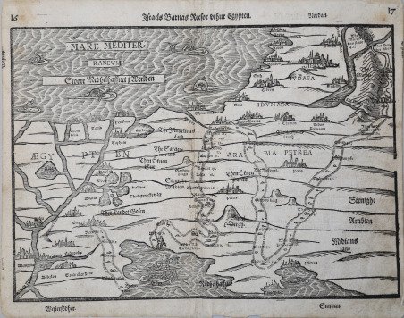
Israels Barnas Reefor sthur Egypten
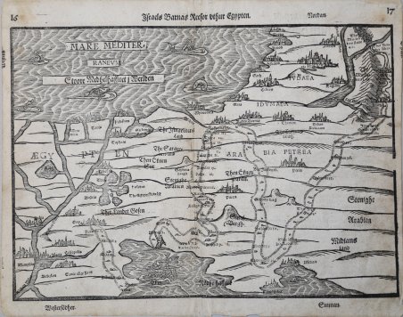
Israels Barnas Reefor sthur Egypten
Formas de Pago
- PayPal
- Tarjeta de crédito
- Transferencia Bancaria
- Pubblica amministrazione
- Carta del Docente
Detalles
- Año de publicación
- 1581
- Lugar de impresión
- Magdeburg
- Formato
- 360 X 260
- Grabadores
- BUNTING Heinrich
Descripción
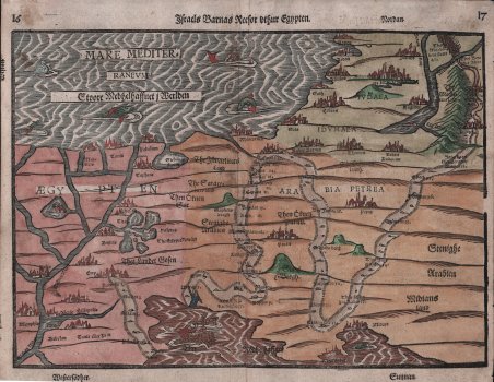
Mappa della Palestina di Heinrich Bunting; viene mostrata la via del popolo di Israele dall'Esodo dall'Egitto al passaggio attraverso il Mar Rosso, attraverso il deserto fino alla Terra Promessa. I passaggi biblici corrispondenti sono indicati nella mappa. Proviene dall'Itinerarum Sacrae Scripturae ' di Heinrich Bunting. Si ritiene che più di 60 edizioni dell'Itinerarum ' di Bunting siano state pubblicate in varie lingue tra il 1581 e il 1757. L'opera di Bunting descrive i viaggi di figure religiose nella Bibbia ed è stata la sintesi più completa della geografia della Bibbia di questo periodo. ' Itinerarum Sacrae Scripturae ' fu stampato per la prima volta a Helmstadt nel 1581 e prodotto in numerose edizioni in Germania. Il libro fu così popolare da essere pubblicato anche con testo in danese, svedese, olandese, ceco e inglese. Henrich Bunting era un teologo e insegnante protestante nato ad Hannover. Frequentò l'Università di Wittenberg e si laureò nel 1569. Iniziò quindi a lavorare come predicatore ma provocò alcune polemiche con i suoi insegnamenti. È meglio conosciuto oggi per il suo libro ' Itinerarium Sacrae Scripturae ' una raccolta di viaggi e un commento alla geografia della Bibbia. Il libro forniva il riassunto più completo della geografia biblica allora disponibile e descriveva la Terra Santa seguendo i viaggi di vari personaggi illustri dell'Antico e del Nuovo Testamento. Caratteristica particolarmente notevole dell’opera erano le sue numerose mappe xilografiche, molte delle quali mostravano rappresentazioni uniche di caratteristiche geografiche e continenti. Oltre alle mappe convenzionali, il libro conteneva anche tre mappe figurative; il mondo raffigurato utilizzando un disegno a quadrifoglio (che si pensa possa rappresentare la Trinità con Gerusalemme al centro), l'Europa sotto forma di una donna incoronata e vestita e l'Asia dipinta nella forma del cavallo alato Pegaso. Xilografia, finemente colorata a mano, testo tedesco al verso, in ottimo stato di conservazione. Map of the Holy Land from Bunting's "Itinerarium Sacrae Scriptura".Shown the way of the people of Israel from the Exodus from Egypt to the passage through the Red Sea, through the desert to the Promised Land. (2nd book of Moses, Exodus). The corresponding biblical passages are noted in the map. This scarce map is from Heinrich Bunting's ' Itinerarum Sacrae Scripturae. It is believed that more than 60 editions of Bunting's ' Itinerarum ' were published in various languages between 1581 and 1757. Bunting's work describes the travels of religious figures in the Bible and was the most complete summary of geography of the Bible of this period. ' Itinerarum Sacrae Scripturae ' was first printed in Helmstadt in 1581 and was produced in numerous editions in Germany. The book was so popular, it was also issued with text in Danish, Swedish, Dutch, Czech, and English. Henrich Bunting was a Protestant theologian and teacher born in Hanover, in what is now Germany. He attended the University of Wittenberg and graduated in 1569. He then began work as a preacher but caused some controversy with his teachings; he was dismissed from appointments in both Lemgo and Goslar. He is best known today for his book, ' Itinerarium Sacrae Scripturae ' (Travel book through Holy Scripture), a travel collection and commentary of the geography of the Bible. The book provided the most complete summary of biblical geography then available and described the Holy Land by following the travels of various notable people from the Old and New Testaments. First published in Madgeburg in 1581, ' Itinerarium Sacrae Scripturae ' was a very popular book for the time. Over 60 editions were published between 1581 and 1757. ' ' A particularly notable feature of the book were its many woodcut maps, many of them showing unique depictions of geographic features and continents. In addition to the conventional maps, the book also contained three figurative maps; the world depicted using a cloverleaf design (thought to possibly represent the Trinity with Jerusalem in the center), Europe in the form of a crowned and robed woman, and Asia as the winged horse Pegasus. Woodcut with fine later hand colour, German text on verso, in good condition. ' Cfr. Laor, E. Mapping of the Holy Land 142.