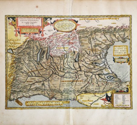
Carta della Gallia Cisalpina [antica regione della penisola italica a settentrione della linea Ariminum-Pisae (Rimini-Pisa), di cui il fiume Rubicone segnava il confine con il resto l'Italia], ' tratta dal Parergon Theatri Orbis Terrarum, il primo atlante storico del mondo antico. Secondo stato della carta, con alcune aggiunte, realizzato dopo il 1601. Vengono tracciate alcune strade cosolari romane e tra Lucca e Pisa compare la strada Aurelia via Antonino, nel lago di Garda il toponimo Vobernum. Esemplare tratto dalla rara edizione italiana del Theatrum Orbis Terrarum stampata ad Anversa da Jean Baptiste Vrients nel 1608 e quindi nel 1612. Nel cartiglio in alto a destra, oltre al titolo, è riportato il privilegio decennale e la dedica: ITALIA GALLICA, SIVE | GALLIA CISALPINA. | "Ex conatibus Geographicis | Abrah. Ortelij. | Cum priuilegio decennali, Imp. Belgicæ, et Brabantiæ. | Venerando Dño D. Francisco Superantio | Veneto, pietate ac sanguine nobili, auctor | lubens merito donabat, dedicabatque Francesco Soranzo (1557-1607) era un nobile veneziano che dal 1598 al 1600 servì come ambasciatore ordinario presso il re di Spagna Filippo II Nel 1597, in una lettera al nipote, Ortelius descrisse l'amico Soranzo: "A Venezia, dubito di avere, tra i tanti amici che ci sono, qualcuno più grande di Francisus Superantius (il suo nome venancario è 'de la Soranzo'), perché molto spesso ho ricevuto favori da lui." [Hessels, Epistulae Ortelianae (1887), 303] In alto, al centro, un cartiglio con 6 righe di toponimi di incerta localizzazione; in basso a destra un cartiglio con due colonne di nomi popoli di dubbia provenienza. Nel cartiglio al centro del margine destro l'iscrizione in latino "Electrides insulas ante Padum, a | priscis descriptas. fabulosas facit Strabo" (Strabone considera immaginarie le isole Elettridi davanti a Padova, descritte dagli antichi) dimostra la profonda conoscenza e anche il rispetto di Ortelius per le fonti consultate. Riguardo, quindi, alla presunta esistenza e localizzazione delle isole Elettridi, Ortelius si limita a ricordare la posizione di Strabone che considerava queste isole - il cui nome significa "isole dell'ambra" e che erano una sorta di "Eldorado" occidentale, sul quale favoleggiavano i navigatori greci - immaginarie. La mappa è realizzata da Ortelius basandosi su fonti classiche quali Livio Ausonio, Tacito, Catone, Plinio, Polibio e Cassiodoro. Circa una decade dopo la pubblicazione del “moderno” Theatrum Orbis Terrarum, Ortelius rispose alle “preghiere di amici e studiosi di storia antica, sacra e profana” e compilò una serie di mappe di soggetto biblico e classico, quasi tutte disegnate da lui. Intitolò l’opera “Parergon theatri”, ovvero “aggiunta, appendice, del Theatrum”, ma al tempo stesso anche complementare al Theatrum: il Paregon theatri forniva per il mondo antico lo stesso materiale che Ortelius aveva fornito per il mondo moderno con il Theatrum: carte geografiche. Lo spirito del Parergon è tutto riassunto nel motto historiae oculus geographia riportato sul frontespizio: la geografia è l’occhio della storia. Le mappe del mondo antico avevano lo scopo di “rendere più chiari gli storici antichi e i poeti”. Le mappe del Paregon sono di tre tipologie: antiche regioni; carte letterarie e carte bibliche. Come sottolinea Koeman “il Parergon deve essere considerato come lavoro personale di Ortelius. Per quest'opera, infatti, diversamente dal Theatrum, non copiò le mappe di altri cartografi, ma ne disegnò lui stesso di nuove ed originali. Riprese luoghi, regioni e territori delle civiltà classiche illustrandone e spiegandone la storia, una materia molto vicina al suo cuore. Le mappe e le lastre del Parergon devono essere valutate come le più importanti incisioni che rappresentano il diffuso interesse per la geografia classica nel XVI secolo”. “Carta dell'Italia Settentrionale ovvero Gallia Cisalpina che dopo la battaglia di Clastidium de. Nice map of the ancient Gallia Cisalpina - the area of North Italy surrounded by the Alps in the north and west, the Adria in the east, and Luca in the south - made by Ortelius on the basis of ancient knowledge from Livius, Ausonius, Tacitus, Cato, Plinius, Polybius and Cassiodorus. From the Parergon Theatri Orbis Terrarum, the first historical atlas of the ancient world. Example taken from the rare Italian edition of Theatrum Orbis Terrarum printed in Antwerp by Jean Baptiste Vrients in 1608 and again in 1612. ' Second state of the map, with some additions, made after 1601. Some Roman consular roads are traced, and between Lucca and Pisa Aurelia via Antonio appears, in Lake of Garda the toponym Vobernum. Title: ITALIA GALLICA, SIVE | GALLIA CISALPINA. | "Ex conatibus Geographicis | Abrah. Ortelij. | Cum priuilegio decennali, Imp. Belgicæ, et Brabantiæ. | Venerando Dño D. Francisco Superantio | Veneto, pietate ac sanguine nobili, auctor | lubens merito donabat, dedicabatque". Under the title cartouche, the dedication to the Venetian Lord Francesco Soranzo (1557-1607) Francesco Soranzo (1557-1607) was a Venetian noble who served as ambassador to Spain from 1598 to 1600. • In 1597 in a letter to his nephew, Ortelius described his friend Soranzo: “At Venice, I doubt if I have, among the many friends there, any greater than Francisus Superantius (his venancular name is ‘de la Soranzo’), for I have felt myself to have had his benefits very often.” [Hessels, Epistulae Ortelianae (1887), 303] Cartouche middle right: "Electrides insulas ante Padum, a | priscis descriptas. fabulosas facit Strabo". One cartouche in middle top with 6 lines of placenames of uncertain location, one cartouche in bottom right corner with two columns of 12 and 11 peoples of uncertain location. The Parergon is the first historical atlas ever published. It was initially conceived by Ortelius as an appendix to his Theatrum Orbis Terrarum but given the considerable success of these historical maps it later became an independent work and remained the main source of all similar works throughout the seventeenth century. Koeman wrote: “This atlas of ancient geography must be regarded as a personal work of Ortelius. For this work he did not, as in the Theatrum, copy other people's maps but drew the originals himself. He took many places and regions from the lands of classical civilization to illustrate and clarify their history, a subject very close to his heart. The maps and plates of the Parergon have to be evaluated as the most outstanding engravings depicting the wide-spread interest in classical geography in the 16th century." The Theatrum Orbis Terrarum, which is considered the first true modern "Atlas". The work was published in 7 languages and 36 editions, for which - in 1570 - Ortelius obtained the privilege, a kind of copyright that prevented other cartographers from publishing his works. The Theatrum represented the most advanced work of cartographic description. Ortelius collected in it the geographical and cartographic knowledge of his time, proposing in 147 spectacular engraved plates the most faithful image of the world then known and, in some extraordinary "historical maps", regions and routes taken from literature, mythology, tradition. Example with magnificent contemporary coloring, paper slightly browned, otherwise in excellent condition. Bibliografia Cfr. L. Bagrow, A. Ortelli Catalogus Cartographorum; cfr. C. Koeman, Atlantes Neerlandici; Peter H. Meurer, Fontes Cartographici Orteliani, n. 21p; M. Van den Broecke, Ortelius Atlas Maps, n. 206 II/II; Van der Krogt, Koeman’s Atantes Neerlandici: 7010H:31. Cfr.

 Descubre cómo utilizar
 Descubre cómo utilizar